|
|
Post by Jake on Feb 3, 2012 12:09:21 GMT -5
Herb, you think the strange thing at the site of the Fairmont Hotel, north edge of La Villita, was associated with the Potosi camp in that area?
|
|
|
|
Post by Jake on Feb 3, 2012 12:04:29 GMT -5
What I mean about the lack of a firing step (I left out a couple of my steps as well, I think) is this:
If Mahan's representation of how to build a stockade is the basic military idea the Mexican army was following along the PW (palisade wall, accepting the traditional name for the area), then the ditch in front they had begun was to supply both the dirt for the embankment against the PW and the earthen firing step within it.
The onset of active campaigning around the Alamo in October or November, I forget when, brought a stop to Ugartechea's progress in digging the trench and building the PW berm. To put it briefly, the conditions of engagement put a stop to any work outside the defensive walls -- that is, the Texans shot anyone they could see.
The failure to dig the trench meant no earth to cover the PW, and no earth to build a firing step. I assume the PW itself was built in its full length and then the earthwork construction began.
Without the firing step, the PW was useless for defensive purposes, because it couldn't be fired over.
So the Anglo-Celts, when pushed into the place and required to defend it, did a quick and dirty trench on the inside to supply the dirt for the firing step, producing Eaton's north trench. It was possible to complete this because it was inside the PW.
Herb, look at my sketch of my "Ivey speculation" drawing of the cross section of the trench that we found, and the probable heights. A little lower than a Mahan or Wheeler stockade, but still pretty solid, with posts about 9.5 feet long and averaging 6 inches thick set into a 2.5 foot deep, 9 inch wide trench, leaving about 7.5 feet of post above ground, with loopholes, the bases of which were intended to be about 4.5 feet above the intended firing step, itself about 2 feet high. Without the firing step, no can use loopholes.
|
|
|
|
Post by Jake on Feb 3, 2012 0:06:32 GMT -5
Yeah, the worst thing about a fixed defense is trying to get the enemy to stand in the right place.
I should switch out the drawing section I put in up there for a new one that includes the back of the church as well, so we could see the whole defensive concept for the south-east corner.
|
|
|
|
Post by Jake on Feb 2, 2012 23:52:12 GMT -5
Another thing we tend to forget is that Maverick while a prisoner in San Antonio during the 1835 fight mentioned that the 18-pounder was placed on the platform in the church -- but the Texans moved it to the southwest corner. Illustrates their different focuses ... foci?
I for some reason can't get myself to use "Texian."
Rich, I don't think anyone has done a full fire analysis for the known Mexican positions outside the Alamo, and the probable ones we have documentary info on, much less the apparent fields and ranges of fire for the Alamo guns, or an effort to take the ground contours into account. Too bad.
Was that second location you mentioned the one down almost at the Little Rhein Steakhouse, the Farimont Hotel site that sort of seems to be a gun position?
|
|
|
|
Mr Rose
Feb 2, 2012 23:43:05 GMT -5
Post by Jake on Feb 2, 2012 23:43:05 GMT -5
What about those other two guys that got out? The ones mentioned by Walter Lord in A Time To Stand, p. 208, and that Gary, bless him, found the actual article and gave it to us on p. 203 in Altar; they came into Nacogdoches and reported the Alamo had fallen, and this story was brought to the Little Rock Arkansas Gazette and published on March 29, a week before any other newspaper put out the word. One was badly wounded, the story says, but apparently not the other one.
Why didn't these guys write down their story, darn it!?!?
|
|
|
|
Post by Jake on Feb 2, 2012 23:23:25 GMT -5
The interesting thing about these cross-sections of the structure of the stockade is this: Mahan, in his sketched cross-section of such a defensive work, shows a very similar construction, but with the ditch on the outside of the defenses, an embankment of earth from the ditch piled against the face of the stockade, and a firing step on the inside of the stockade also made from the earth from the outside ditch. This leads me to offer you what Mark Lemon calls “one of Ivey’s speculations” – I like that phrase. We know from archaeology that the ditch outside was not finished, and in fact ended near the southeast corner of the low barracks with an abrupt tapering off: 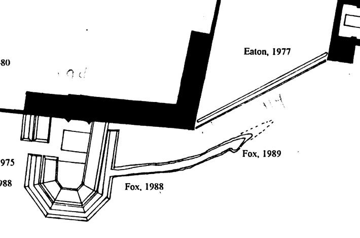 I can’t give you an image of Mahan’s drawing because that’s apparently still in copyright – I could do a tracing of it if we needed it, though. Oddly, the CAR 1992 report by Anne Fox on the 1988 and 1989 excavations that found the taping-off of the outside ditch didn’t mention this detail, but it is in the field drawings: “Anne A. Fox, 1989 Field School, profile drawings, units E1004N1991, E1004N1992, E1004N1993, on file at the Center for Archaeological Research, University of Texas at San Antonio, San Antonio, Texas.” The drawing I show a piece of above was published in James Ivey, “Archaeological Evidence for the Defenses of the Alamo,” Alamo Journal 117(June, 2000)1-8. Earlier I gave you Wheeler’s description of a stockade, and his remark about how you didn’t want to do this where it was exposed to cannon fire – but if you put an earthen embankment against the outside, you’re considerably increasing the stockade’s resistance to cannon fire, and thereby considerably increasing its defensive capabilities, and making this front stronger. It looks like that was what the Mexican army intended, and they had started the ditch that would supply the dirt to do just such an earthen-faced stockade, where in fact the stockade is a revetment for a defensive berm – but the work abruptly stopped before they got much of the ditch dug along this face. A little problem with Texan sharpshooters. This means that the stockade not only did not get its earthen covering or ditch out front – it also didn’t get its firing step. It was a wall of seven-foot high posts with firing loopholes at intervals but above the average man's head, with no way to actually fire from it, defend it or have any sort of defense for the cannon position when the cannon (that I don't show on the plan above) wasn’t firing. I think TRK is right, and the ditch to the north wanders somewhat, because it was ripped fast and furious out of the ground by the Texans after they entered the Alamo, as the only way to finish the firing step and make the stockade defensible. I call this my “unified trench theory.” What I like about it is that it makes Eaton’s find at the corner of the church more significant, because it suggests, at least, that we’re getting a glimpse of the actual dynamics of that desperate fortification effort immediately after February 23, 1836. So imagine that narrow, neat little trench north of the palisade wall as wider and a fair amount more irregular in alignment and outline. |
|
|
|
Post by Jake on Feb 2, 2012 22:27:22 GMT -5
Let me put in a few diagrams here to illustrate what I think was going on along the stockade wall (call it the palisade wall if you like, we have for so long it’s probably a permanent habit). In the discussion on the palisade wall in: alamostudies.proboards.com/index.cgi?board=alamohistory&action=display&thread=44&page=2it became clear that most of the people involved did not follow the description of this defensive structure that I had put together in “Archaeological Evidence for the Defenses of the Alamo,” in The Alamo Journal 117(June, 2000):1-8. Partly this was because I left out the page reference to the cross section diagram of a palisade wall (actually, a stockade wall, according to Wheeler) in The Elements of Field Fortification by J. B. Wheeler (New York: Van Nostrand, 1882), pp. 161 and164. The book is available as a public domain online ebook at: books.google.com/ebooks/reader?id=R7VEAAAAIAAJ&printsec=frontcover&output=reader&pg=GBS.PP1I included a revised sketch of Jack Eaton’s plan of the stockade wall given in an earlier post – let me add one of his cross-section drawing of the northern trench: 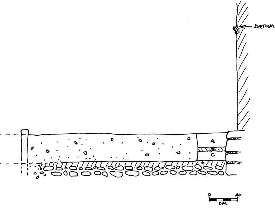 Given this, combined with my information about the stockade trench to the south, I came up with a sketch of the cross section of the apparent structure of the stockade, near the church. 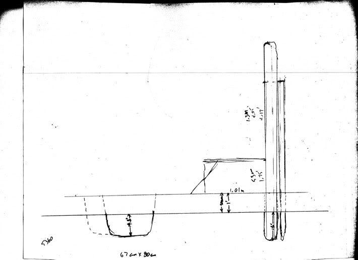 Just a rough pencil sketch, more or less to scale, but it shows the problem here (the wider trench to the left is Jack’s northern trench, in solid, and the apparent true width of this trench in dotted). Normally, according to Wheeler, such a construction has the stockades set something like three feet into the ground, and the tops of the posts about 7 feet above ground. Wheeler shows a typical stockade looking like this: 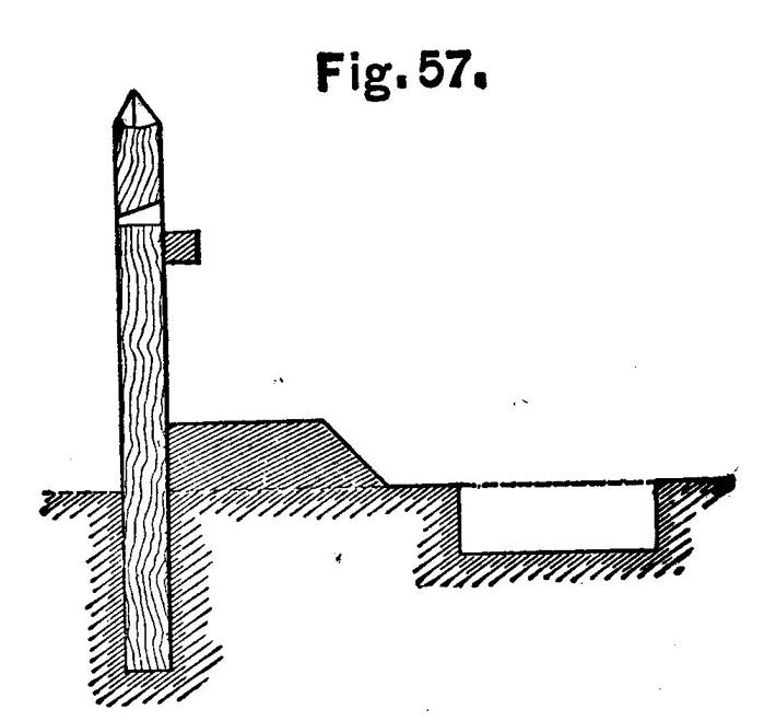 This is his cross-section of one version of a stockade, on his page 161. This is his plan of one way of building a stockade with loopholes, on his page 164: 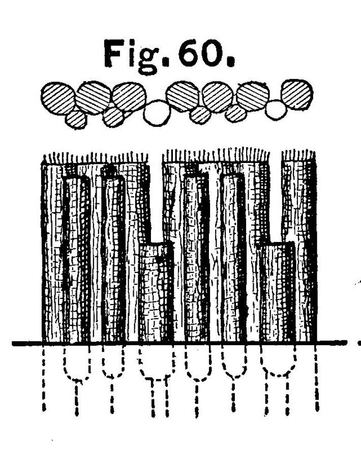 What we found was the bottom-most part of the ditch they were set into, and what survived was 18 inches deep. So one would expect up to 18 inches more depth – that is, the ground surface could have been up to 18 inches higher than the top surface Jack found. On this sketch, I’ve given it 1 foot, for a total depth of 2.5 feet, which would put the surface at the time of the battle 30 cm higher, or at a little above the midpoint of the square-edged base plate of the lowest-most carved pieces of the pilaster shown in Eaton’s cross-section drawing, slightly (ca. 3 cm, about an inch) higher than the surface he shows with a dotted line labeled “Pre-excavation paved level,” and that looks like the level of the surface in some of the 1840s drawings, more or less. 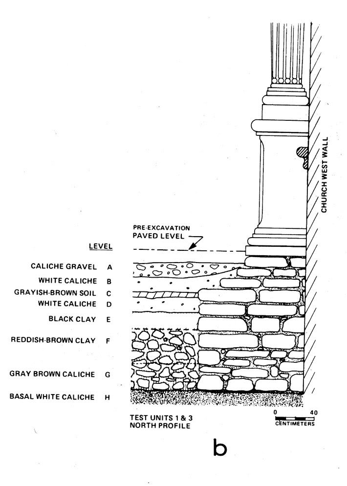 We know that the Army raked off a lot of fill from various places around the church and convento – the north wall excavations in the courtyard east of the long barracks (James E. Ivey and Anne A. Fox. Archaeological and Historical Investigations at the Alamo North Wall, San Antonio, Bexar County, Texas. Archaeological Survey Report no. 224, Center for Archaeological Research, University of Texas at San Antonio, 1997 – you can download a copy from the CAR reports site) and Anne’s work around the tambour at the south gate found this over pretty much everywhere we’ve looked, although we don’t know how far down they took the surface in any of these areas. It appears from the photos of the front of the church in the 1860s that the tops of the foundation stones are showing all along the front, so that’s a removal of at least 45 cm, or 18 inches, in this area. So as a result of looking at Jack’s excavations, in spite of the other questions raised about them, it appears that the level of the ground at the front door of the church at the time of the battle in 1836 was at the level Jack indicated as his “Pre-excavation paved level,” which is pretty much the same level as the surface today, instead of the lower level I was willing to accept in an earlier post, based on looking at the 1860s photos. |
|
|
|
Post by Jake on Feb 2, 2012 22:10:36 GMT -5
Sorry, Rich, I just got carried away with thinking about a cannon up there. But pursuing your thinking about defensive capability in this area, look what we do have, assuming that the stockade ran the way the maps show. We have the single cannon and however many musket guys you can afford to place along the stockade wall; one of the three cannon on the church firing south, and one or both of the cannon in the lunette firing along any line from east to south, if they were in barbette, and however many men you could afford along the top of the wall of the low barracks firing south, plus a few firing east to southeast off the end of it. That's actually a strongly defended face. If you assume barbette cannon in the lunette, instead of embrasured cannon locked into two lines of fire from an embrasured tambour.
Wheeler says "A line of stout posts or trunks of trees firmly set in the ground, in contact with each other, and arranged for defence, is called a stockade. A stockade is used principally when there is plenty of timber and little or no danger of exposure to artillery fire. It is frequently used to close the gorge [the unentrenched back side] of a field work, and to guard against the work being carried by a surprise, by bodies of infantry attacking the work in rear."
The fact that this stretch of open area, which would count as a gorge, received only this defense, suggests that a) the Mexican army didn't have enough time to do more, and/or b) they thought this was enough of a defense.
|
|
|
|
Post by Jake on Feb 1, 2012 20:04:17 GMT -5
Oh, man, I hate it when the voice of reason wanders into the party.
The angle Jack found for the big north ditch carries it to a point 36.6 feet north of the southeast corner of the low barracks. That's as good a distance as any for the north end of the structures that Labastida shows on his plan of the Alamo. So from the viewpoint of having a place to go, that's a pretty good one.
And the point about using the low barracks for flanking fire along the stockade (I've started calling it that because Wheeler, 1882, is quite specific about what you call which -- but the force of tradition is against me on that, so take it as an idiosyncracy) is a good one. But ...
OK, take the discussion about having to trust primary documents as givens until you have reason to doubt one or another part of it, and then start being careful with it, as already said. We can treat this as a theoretical discussion, to see if we develop doubts about all the maps we've trusted to one extent or another so far.
So: But ... if you were building those defenses, and you wanted to take advantage of flanking fire down the face of the stockade, then a gun position on the roof of the low barracks would be a great place, supported by rifle/musket fire. But it was something like 15 feet or more, probably closer to 20 feet, high, and the stockade was at most about eight feet high, so would you need to offset the west end of the stockade? Well, maybe so, because otherwise firing a cannon down the face of the stockade from the roof of the low barracks would pretty much take out all the defenders along the stockade wall. In fact, that would seem to me to be a problem no matter how you arranged the defenses here, which may be why we don't hear of a cannon on the top of the low barracks.
|
|
|
|
Post by Jake on Jan 31, 2012 15:48:34 GMT -5
Yes, I suggested that in the fourth paragraph from the bottom in my big post above: maybe "the southern trench (which apparently contained the palisade wall itself) ran as the historical maps showed it doing, and the northern trench may have curved somewhat and acquired the same angle farther to the west than we were able to follow it." I'm imagining a very shallow crescent-shape to the wider ditch, with symmetrical slight curves towards the stockade wall itself at either end (and we've only seen the angled part of the northeast end), and the rest of it running pretty much parallel with the stockade wall.
|
|
|
|
Post by Jake on Jan 30, 2012 17:12:23 GMT -5
In the process of thinking about the question of ground level at the front of the church as raised by Zaboly in Altars For Their Sons, I realized that the photographs and drawings take us back only to about 1848, and that the archaeological evidence for the ground level might allow information about ground level in 1836. I looked again at Eaton’s report, Excavations at the Alamo Shrine, and his record of the excavation of the palisade trench at the southwest corner of the church. This does give us some information about ground level, although it does not allow us a simple and direct statement of what that was. In the process, I find I have raised more questions than I have answered – and I think the members of the Forum will enjoy getting involved in this. Based on Eaton’s report, the published information about the Palisade Trench has it as fairly simple. “The trench began about 65 cm out from the building wall [of the Alamo Church] and extended southwest (250° magnetic) ... three meters from the wall.... The trench averaged ca. 70 cm in width and ca. 45 cm in depth.... Also during excavation, traces of what appears to have been the edge of a second palisade trench were uncovered in Units 7 and 12. The remnants of this second probable trench is located 1.90 m (6 ft.) south of the first trench, extending parallel with it, and is of the same orientation.” (pp. 24-25) The thing is, this information is apparently wrong in a number of ways. First, Jack all but ignored the southern trench line, and focused his attention on the north trench, full of bullets, shell fragments, and other material from the battle itself. From the description quoted above, it is clear he considered what we found to have been the northern edge of a second trench of the same general size as the first one to the north, rather than the narrow ditch that I describe. He did not include any plan of this trench other than a single line showing its location (probably intended to indicate its northern edge), on his figure 3, although its existence is part of the evidence to support his interpretation of the palisade as “consisting of two rows of cedar piles six feet apart, with the space between filled with earth from a ditch dug in front” (Eaton, 1980, p. 25 – see also his discussions on pp. 8 and 47). 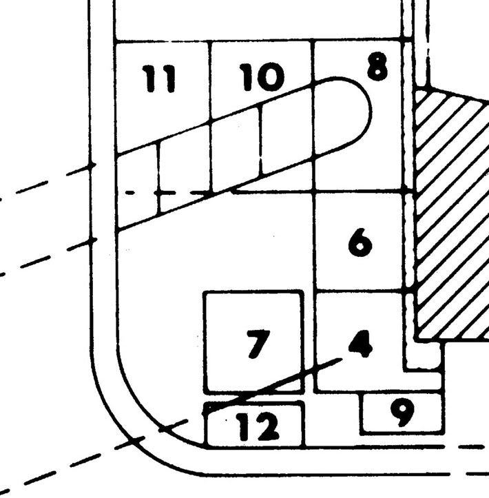 Second, Jack gave the angle of the trench as 110° west of magnetic north, which at the time of the excavation was 9½° west of true north. This happens to be the same bearing as the front of the church, so the angle between the front of the church and the ditch is also 110 degrees. (On p. 24 Jack says the angle was 250°, but this is the same direction measured the other way around.) Jack says on p. 8 that the palisade ran “between the southwest corner of the old church and the southeast corner of the quadrangle,” that is, the southeast corner of the Low Barracks – but as Rich Curilla and Tom Kailbourn pointed out in their discussion of this in 2007on the Forum in “Alamo History:: Paging Mark Lemon: palisade question,” located at: alamostudies.proboards.com/index.cgi?board=alamohistory&action=display&thread=44&page=2this angle would take the ditch and the trench to its south to a point on the low wall running north from the Low Barracks, about 36.6 feet north of the corner that virtually every map indicates it went to. Third, there are discrepancies between what Jack shows in his diagrams and what is visible in the photographs, in the size and angle of both trenches as shown by the (very sparse) available information. How do we reconcile the difference between the results of Eaton’s excavation and interpretation with what apparently was the actual plan here on the southeast front of the Alamo? I came up with a supposition that Jack made an erroneous calculation of the actual direction that the ditch should run in that would have been fairly close to his 110° angle, implying that he did not realize there was a problem with the angle. That may well have happened, but when you examine the photograph of the excavation looking straight down from the roof of the Alamo (figure 10a), however, you can see that its angle appears to be about the same as Jack’s plotted angle on the plans shown in figures 3 and 11. In other words, the northern trench doesn’t appear to run towards the corner of the Low Barracks. How could this be? Furthermore, the southern, narrow trench does not seem to be visible in the photograph in figure 10b, even though Jack’s diagram shows that it should show up in the south face of unit 7 at the top of the picture. But there is a strange dark blotch on this south face, in the southeast corner of the unit. Since we don’t have the field notes and unit plans and sections, nor any of the photographs other than the ones Jack included in the report and the three others (personal ones, I think, possibly by Anne Fox) that Bruce was able to find and include in his summary of this excavation, this is all we have to go on as actual evidence, other than my memory of what we saw. It is interesting to note that if the south palisade trench ran directly towards the southeast corner of the Low Barracks (and this is the way I remember its orientation running), as the maps show it, then it would have to have run across unit 7 at its southeast corner, as shown below in the plan, and the dark blotch visible in the photograph would be our only available view of a cross-section of this trench. But this raises the question: in figure 3, did Jack draw the line of the southern trench intentionally to parallel the northern one, as he described it doing, even though it didn’t, but ran about 17° more southerly? If we assume that Jack changed the angle, then the southern trench (which apparently contained the palisade wall itself) ran as the historical maps showed it doing, and the northern trench may have curved somewhat and acquired the same angle farther to the west than we were able to follow it. If Jack made this change, presumably it was because he was sure the angle shown on the field drawings of the units was wrong (essentially what I’m saying here is that he thought I had drawn it wrong, since as far as I recall I did all the recording on the trench itself) and that the southern trench actually did parallel the northern trench. Looking at that photograph in figure 10a produces some other problems as well. For one thing, the trench as shown in the picture seems far wider than the trench as shown in the diagrams in figures 3 and 11. In fact, using the sizes of the visible units, I estimate that rather than the 70 cm wide that Jack says it was, it was actually more like 110 cm. Rather than 2.3 feet wide, the trench appears to be something like 3.6 feet wide. TRK, you have some expertise in photo interpretation – what would be your judgement on this? Any of the rest of you who have abilities in this area, give it a look as well. These considerations give us the following rough diagram, showing what I believe the evidence suggests. In this plan, the southwest corner of the church is visible on the right, and Jack’s sketch of the northern trench is shown as a dotted outline. I have shown the southern trench in its approximate true size in dotted outline where Jack’s diagram has it. In solid line I have shown the apparent true angle of the southern trench, and the apparent true size of the northern trench. The double line on the left that curves at the lower left corner was a curbing that marked the edge of the “street,” and our excavations stopped there. Whether traces of the trenches might be found farther to the west is unknown. 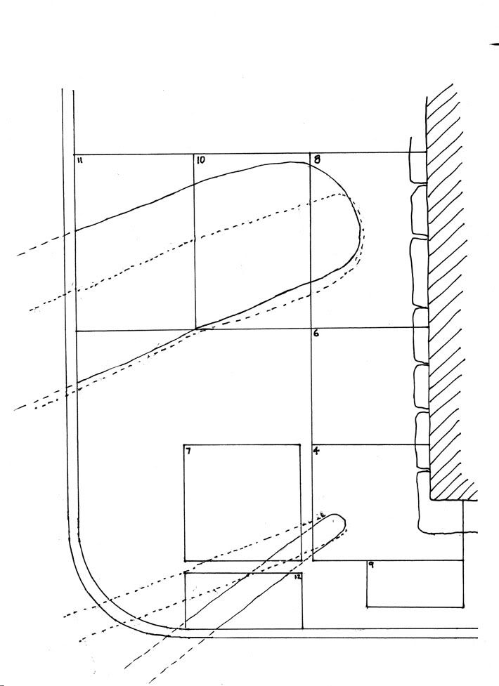 |
|
|
|
Post by Jake on Jan 27, 2012 18:43:14 GMT -5
Thanks, Joy, for that link. I was regretting that I didn't take a picture of the sign that I saw, but I was assuming, wrongly it appears, that the report would have been published and we'd be able to see what they had actually found. So you connected me, and everyone else who hasn't found this site by chance, with the images I saw at the site.
The drawing of the fortification is what I remember best, and it still offends me. Notice what the caption says: "In this location, they dug a trench in which they would have placed wooden posts to form a palisade." "Would have placed" suggests to me that they didn't actually find the traces or post-molds of a line of palisades at the bottom of the trench -- that this is, for some reason, assumed to have been built there.
I've been trying to track down Cary Jeffrey Hanson, so I could ask him about the 41BX1752 site and its report. Anybody else know where he might be?
|
|
|
|
Post by Jake on Jan 23, 2012 11:09:01 GMT -5
So far, I've found (according to a remark in Hanson's thesis, location given above), that someone named Anderson of PBS&J had written a draft version of the report on the trench, 41BX1752, but that as of late 2010 it was not yet published. Whether PBS&J (I tend to read that as Peanut Butter Sandwich and Jelly, but it's actually the consulting firm of Post, Buckley, Schuh and Jernigan) was going to publish it or the Texas Historical Commission, I can't tell, since I can't yet find a publications access point for either organization. THC site is bizarre -- doesn't seem to have a professional component, only public and teachers access points.
So anyway, I can't give you a link to the 41BX1752 report on the 1835 entrenchments at the southeast corner of Main Plaza.
|
|
|
|
Post by Jake on Jan 22, 2012 13:56:53 GMT -5
C. J. Hanson wrote up the report on an excavation at the southwest corner of Main Plaza as his thesis in 2010, and it's available online at: repositories1.lib.utexas.edu/bitstream/handle/2152/ETD-UT-2010-12-2473/HANSON-THESIS.pdf?sequence=1This excavation did not find any military construction in this area. [Let me add to this too-cryptic posting that what Hanson found was apparently a couple of privy pits and ditches in the area of the southwest corner of the plaza, opposite the Plaza fortification site at the southeast corner. Hanson's site was 41BX1753, about 300 feet west of 41BX1752, the site I wanted to discuss here, but we don't have the final report.] |
|
|
|
Post by Jake on Jan 9, 2012 18:12:10 GMT -5
Just back from out of town.
Kevin, San Antonio missed the 200th of the Casas revolt as well, unless there was some commemoration on Jan. 22, 2011 that I missed hearing about. Too bad, if that one had worked Texas could well have been the kick-over to a successful Hidalgo revolt, and the battle of the Alamo would never have happened. Or would it?
|
|
