|
|
Post by bmoses on Oct 20, 2007 18:19:52 GMT -5
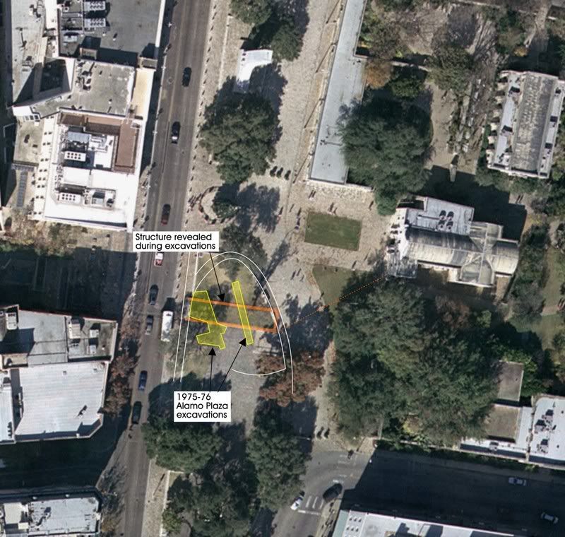 Map of the excavations in Alamo Plaza, 1975 Map of the excavations in Alamo Plaza, 1975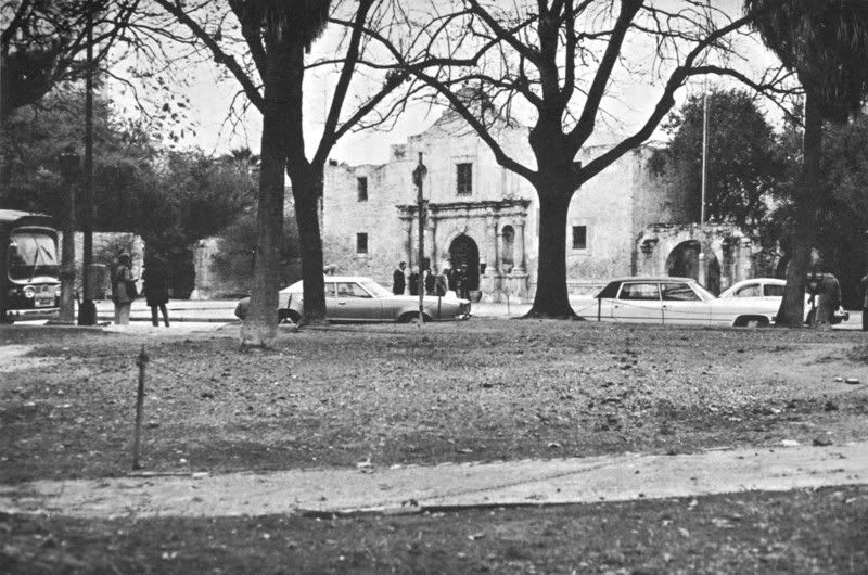 Photograph of the area taken just prior to the beginning of the project. Photograph of the area taken just prior to the beginning of the project.The first archaeological investigations undertaken in Alamo Plaza began in the early Summer of 1975 and were completed by the fall of that same year. The project, lead by Anne Fox under the direction of Project Investigator Dr. Thomas Hester of the Center for Archaeological Research-UTSA, was designed to target and relocate buried remains of the Low Barracks building. The excavations were soon successful and the precise location of the Low Barracks building was again known. This building, probably built around 1803 by troops of the Flying Company of San Carlos de Parras del Alamo, had served as both a barracks (east side of gate) and jail (west side of gate). It later served as a living quarters and hospital during the Mexican occupation. An unexpected find of the 1975 excavations (and very important for subsequent Alamo studies) was the discovery of the northeastern portion of the lunette just outside what would have been the south wall gate. The find was so important that another major excavation was organized in 1988 to continue to uncover the lunette in the same area. 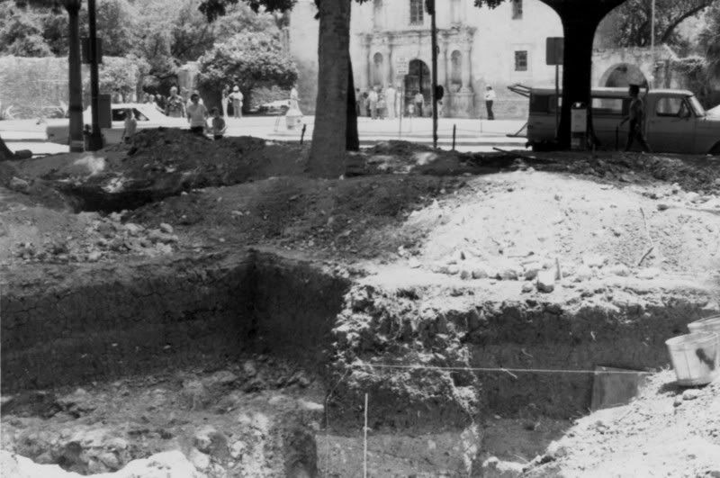 Excavations underway with the Alamo shrine in background. Excavations underway with the Alamo shrine in background.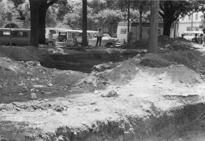 View to the southeast looking across Trenches B (foreground) and C (background). View to the southeast looking across Trenches B (foreground) and C (background).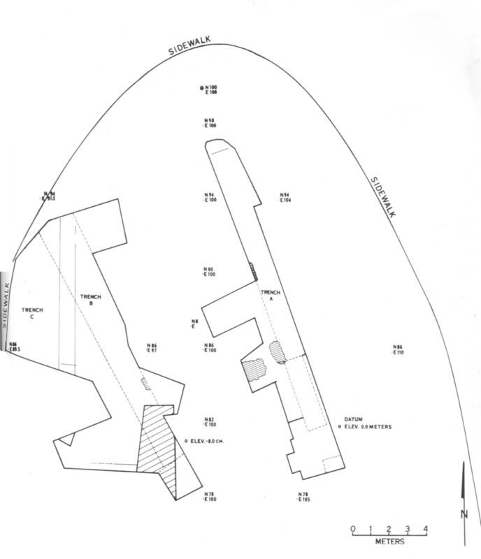 Plan map showing archaeological excavations in Alamo Plaza in 1975.Description of Excavations Plan map showing archaeological excavations in Alamo Plaza in 1975.Description of ExcavationsThe search for remains of the Low Barracks building began with a careful archival study of early Alamo compound maps. Soon, archaeologists focused on details included in two maps drawn by Theodore Gentilz and F. Giraud, respectively. From these maps, a general area some nine by thirty meters was staked out by project archaeologists. The actual trenches were then started with the aid of a backhoe and oriented so as to avoid the roots of several large trees. Careful monitoring of the trenching allowed archaeologists to remove the overburden down to what were thought to be archaeologically significant deposits. 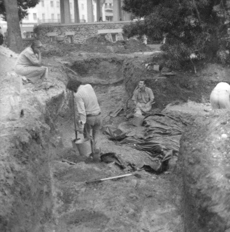 Project Director Anne Fox discusses the progress of excavations with Jack Eaton.Trench A Project Director Anne Fox discusses the progress of excavations with Jack Eaton.Trench AOpened to the east, Trench “A” was excavated by backhoe down to about 70 centimeters below the surface (cmbs). A soil change from black clay to a brownish clay containing dark gray lenses marked the transition to nineteenth century deposits. Soon after several test units were opened it was realized that archaeologists were still some distance above battle period levels. The backhoe was brought back in and an additional 50 centimeters of deposits were mechanically removed. Several pieces of limestone rock were encountered by the backhoe and hand excavations were resumed. After carefully cleaning off the areas of limestone it was determined that these chunks of consolidated stone were in fact the southern wall footings of the Low Barracks. Soils below the top of the footing were found to be sterile of artifacts while a brown soil containing nineteenth century materials extended across an unbroken level just above. Trenches B and CAnother backhoe trench, Trench “B”, was opened parallel to and about 5 meters west of Trench A. The initial backhoe trenching was taken to approximately 80 cmbs. Below this, a zone of late-eighteenth to mid-nineteenth century artifacts were encountered in a rather dense grayish matrix. Immediately below this zone and scattered across this entire portion of the site was a compact layer containing medium sized stones embedded in a friable tan soil. This layer was soon identified as a natural part of the substrata. A feature (which turned out to be a late nineteenth or early twentieth century trench) was observed in the northern end of Trench B and so Trench C was opened as an extension of the western side of Trench B. The intrusive historical trench, thought likely to be connected with turn of the century park construction, was the only feature observed in the northern portion of the Trench C. However, another possible wall footing containing large rocks had been observed in the southeastern wall of Trench B and a light gray midden soil was uncovered a short distance south of it and extending into the western wall of the trench. The new feature, subsequently identified as remains of the Lunette, had a sharp line of demarcation along it’s north and west sides indicating that it had been excavated through the overlying rubble-filled matrix. Soils within this feature contained almost exclusively mission period artifacts. As archaeologists began cleaning up and mapping this new feature, it became clear that the Lunette Trench had been filled in by numerous deposits that formed discrete lenses of varying thicknesses. The bottom of the trench was ultimately encountered at a depth of 205 cmbs. 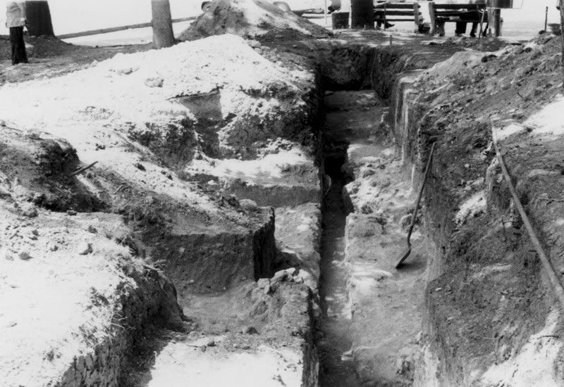 View looking north in Trench A. View looking north in Trench A.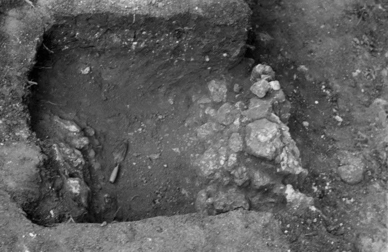 The wall footing of the Low Barracks building exposed in the west side of Trench A. The wall footing of the Low Barracks building exposed in the west side of Trench A.  This photo shows the layered soils encountered during excavations in the Lunette Trench. This photo shows the layered soils encountered during excavations in the Lunette Trench.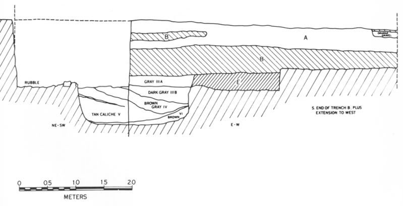 West wall profile of Trench B showing stratigraphy and features including the Lunette Trench. West wall profile of Trench B showing stratigraphy and features including the Lunette Trench. |
|
|
|
Post by Allen Wiener on Oct 20, 2007 18:51:00 GMT -5
Many thanks Bruce! This is terrific stuff. I have never seen these photos before, nor was I aware of these excavations. I especially like the aerial photos and overlays, which give us real perspective. Like Mark's model, this is adding enormously to our understanding of the Alamo's actual appearance in 1836.
In March I noticed that there is a marker where the main gate would have stood; do you regard that as an accurate location? In line with Gary's plan to restore the Alamo, it would be nice if the most could be made of these findings in reconstructing the compound.
I look forward to seeing more on this.
AW
|
|
|
|
Post by bmoses on Oct 20, 2007 20:43:52 GMT -5
I'm glad you liked the post Allen, I’m hoping that there will be a good bit that I can contribute to the topic “Alamo Archaeology.” There have been numerous excavations in and around the compound since the 1960s and relatively little is known publically about many of them. I don’t think there will be any shortage of potential threads in this sub-board. Most (but not all . . . some have still never been written up!) of the previous work has been summarized in technical reports that are often not readily available to the public and/or seldomly read due to their technical nature. "In March I noticed that there is a marker where the main gate would have stood; do you regard that as an accurate location? In line with Gary's plan to restore the Alamo, it would be nice if the most could be made of these findings in reconstructing the compound." Allen, I believe that marker was placed as a result of the 1975 and the 1988 excavations that defined the south gate area, although I am not positive as to how they determined where to place it after the units were backfilled. Oh, and sorry about the size of the first post Jim . . . I'm just not sure of how else to show these projects without including a fair number of images. |
|
|
|
Post by Jim Boylston on Oct 20, 2007 23:28:06 GMT -5
No worries. I think we're all grateful for all this info. Keep it up!
I just posted the warning so the dial up members would know they have a wait. But it's sure worth it!
Jim
|
|
|
|
Post by bmoses on Oct 20, 2007 23:39:01 GMT -5
The principal discoveries of the 1975 excavations in Alamo Plaza were the limestone wall foundations of the Low Barracks and the defensive Lunette Trench built to guard the entrance to the Alamo through the South Gate. From the bottom of the Lunette, a scattering of lead musket and rifle balls as well as a cannon shell fragment were recovered.
Comparing the excavated wall foundations uncovered in 1975 to the Giraud (1849) and Gentilz (1849 or 1850) maps proved useful to project archaeologists since, in many ways, the two maps agree rather closely on important details. Portions of foundations were exposed in two separate areas of the west wall of Trench A and appeared to represent interior and exterior wall footings of the Low Barracks. The distance between the exterior portions of these foundations was approximately 6.15 meters (17 feet). A third intrusion of limestone in the southeastern portion of Trench B appeared to be a continuation of the south wall footing toward the west and closer to the gate.
The location of these three foundation features was then compared to the relative position of other buildings in the compound and their relationship to the Giraud and Gentilz maps. The general location of the features was very close but the angle of the archaeological elements of the Low Barracks wall appeared to be different from the two maps. It was not clear at the time of this project whether the angular difference reflected an error in both the Giraud and the Gentilz maps or whether instead there may have been some kind of displacement of the remnants of the foundation in Trench B.
The discovery of a portion of the fortification trench, or Lunette Trench, to the southeast of the South Gate was a gratifying surprise to the archaeologists. The feature had been illustrated on numerous historic maps including ones by Potter and Berlandier as well as a composite map created by Mexican officers. No two observers agreed on the size, shape and/or location of the ditch and parapet arrangement within which were mounted two or three cannon for protection of the southern gateway. It has been mentioned that the Lunette appeared to protrude an excessive amount out and away from the mission wall. The reason for this protrusion becomes clear when one realizes that there must be room behind it for a parapet behind which the cannon required at least double their length to allow for the recoil upon firing. Behind that, there must be room for personnel and equipment to pass through the gate.
It was noted that the walls of the Lunette Trench were straight and uniformed, indicating that the trench was carefully dug. Fill materials recovered from inside the trench suggest that the feature was likely filled by U.S. troops when the Army restored the south wall structure in 1848-1849.
One of the problems of reconstructing the lay of the land at the time of the battle didn’t become clear until excavations resumed in the area of the South Gate in 1988 and 1989. At that time, a larger area was opened up and the plan of the Lunette was revealed. It was then fully realized that landscaping and massive modifications to the plaza after the time of the battle and prior to 1975 had stripped away the actual 1836 ground surface leaving only the subsurface portions of the Lunette Trench to mark the feature. All remains of the above ground portion of the defensive parapet were in fact completely gone.
|
|
|
|
Post by TRK on Oct 22, 2007 15:42:06 GMT -5
I've had the report of the 1975 excavation Bruce so well describes here, The Archaeology and History of Alamo Plaza, by Fox, Bass, and Hester, since it was published in 1976. However, not until I saw in close juxtaposition the last photo and last line drawing in Bruce's first post, did I realize that the diagram is equivalent to the view shown in the photo. This makes much clearer the orientation of the bottom of the 1835-36 lunette trench and how it related to trenches B and C of the 1975 excavation. The photo also gives a good idea of the more than 2-meter depth (below current surface) of the lunette trench.
Regarding the lunette trench, it's interesting that Fox et al noted (p. 52) that "Apparently the ditch was dug carefully (the walls are straight and uniform) and may have been refilled not too long after the battle, since pick marks are still visible in the west wall." However, later in the same paragraph, the authors seem to contradict themselves when they observe that the fill of the lunette trench contained, among other artifacts, a metal button then thought to have dated to somewhere between 1837 and 1865, and a percussion cap "which probably would not have arrived in Texas until after 1840." I don't know if a more precise date has been attributed to the button, but I believe that percussion caps would not have been unknown in Texas by 1835-36.
|
|
|
|
Post by Allen Wiener on Oct 22, 2007 15:49:29 GMT -5
I seem to recall reading that Crockett had a percussion rifle, which he had had converted from a flintlock. I'm not sure if he took that to Texas or not.
AW
|
|
|
|
Post by stuart on Oct 23, 2007 0:33:45 GMT -5
In one of Reuben Brown's narratives of the fight at Agua Dulce he describes trying to use a pistol; "I had loaded while running, the cap exploded but did not fire."
|
|
|
|
Post by Herb on Oct 23, 2007 9:13:59 GMT -5
There's other comments about percussion cap weapons during the Revolution, though mostly related to San Jacinto. Clearly the vast majority of men had flintlocks, but apparently percussion cap weapons weren't too rare.
|
|
|
|
Post by bmoses on Oct 25, 2007 21:58:18 GMT -5
Regarding the lunette trench, it's interesting that Fox et al noted (p. 52) that ". . . the ditch . . . may have been refilled not too long after the battle"; However, later in the same paragraph, the authors seem to contradict themselves when they observe that the fill of the lunette trench contained, among other artifacts, a metal button then thought to have dated to somewhere between 1837 and 1865, and a percussion cap "which probably would not have arrived in Texas until after 1840."... I spoke with the author, Anne Fox, about this apparent contradiction yesterday but, unfortunately, she didn't have much that she was able to add to the discussion all of these years later. I would think that only two or three late (1837-1865) artifacts in the fill might readily be explained by bioturbation, especially items as small as a button and a percussion cap. It's amazing what burrowing animals and insects (Harvester ants, for example) can do to move artifacts up and down within a deposit, especially in loose and silty fill materials. There are two main reasons I would go along with the theory of a relatively rapid infilling of the Lunette Trench soon after the battle as Mrs. Fox suggested. First, in looking at the profile and the photograph in the original post above, there appears to be an apparent lack of stratified natural lenses near the bottom of the trench. You can contrast this with the much more numerous and thinner lenses created in the trench at La Villita Earthworks ( see profile and photos on that thread) which is thought to have remained open for several years. Also, if the Lunette had remained open for years (long enough to be open when the later period artifacts would have been deposited), one would expect to see many more of these later period artifacts. Low places on the landscape have a tendency to collect debris. It will be good to go back through the report on the 1988 and 1989 UTSA fieldschools in Alamo Plaza since that work targeted much of the remaining portions of the Lunette Trench as well as the South Gate. I'll review that report and pull together a summary and photos in a new thread. |
|


