|
|
Post by Kevin Young on Jan 9, 2010 9:29:24 GMT -5
Thanks Bruce for more than refreshing my mind on this aspect of the 1812-1813 events.
|
|
|
|
Post by bmoses on Jan 9, 2010 17:35:03 GMT -5
This really fascinating stuff. I sort of overlooked this one for too long. Now I'm hooked. Thanks Paul, Kevin and everyone for the feedback - this period is truly fascinating! The other day, Kevin and I briefly discussed how the Texas Revolution hadn’t occurred in a vacuum. Instead, it was a chain of events of a much broader progression which had started with the transfer of the Louisiana Territory by Napoleon Bonaparte to the United States in 1803 and the subsequent militarization of Texas by Spain. The resultant changes across the region forever altered the future of the sleepy frontier outpost of San Antonio de Bejar. Considering its place within this larger context, the Battle of the Medina could be considered an initial, although unsuccessful, climax to an opening salvo in the struggle for Texas independence. Of the more than fourteen-hundred souls that made up the Republican Army of the North, nearly 600 were Americans. Amongst their ranks were men from almost every one of the seventeen states, including veterans of the American Revolutionary War. The engagement below the Medina was a brutal end for most of these men. Historic accounts have stated that only ninety Americans returned to the United States after the battle. The first Texas revolution included a rich cast of characters and was packed full of high drama that included coups and counter coups, invasions, a siege, several large and violent Napoleonic battles, revenge killings, mass murder, betrayals, love, intrigue, etc. The death of Captain Juan Bautista de las Casas serves as an interesting example. Six months after leading a military uprising at Bexar in January, 1811, Casas was captured and the revolt put down. Casas was hauled away to Monclova where he was court-martialed as a traitor and shot in the back. His Spanish captors then severed his head, buried the body at Monclova, and shipped the head back to San Antonio where it was displayed for months on a tall pole in Military Plaza. In my opinion, this period has been largely overlooked by historians to the determent of us all. I suppose it could be because the American-backed Tejano revolution ultimately resulted in failure. Or perhaps it was because the events of 1835-36 soon overshadowed the earlier uprising. The lack of American survivors remaining to tell the story of this tragic epoch may also have contributed to its deflated status. Whatever the reasons, I do hope that one day historians will see to it that the events of this tumultuous period are elevated to their proper place in the story of Texas. With any luck, the site of the Battle of the Medina will soon be identified. Perhaps then, this important epoch in Texas history will begin to regain its proper standing with in the story of Texas and the history of the United States. |
|
|
|
Post by Kevin Young on Jan 9, 2010 23:05:13 GMT -5
What is also interesting is how some of the 1813 survivors end up back in Texas for what can be considered round two: the Texas part of the Mina Expedition of 1817. Henry Perry, who was in the 1813 mess and survived ended up in New Orleans for the events at Chalmette and then on the Mina Expedition. When he broke off and attacked La Bahia only to end in defeat at the Perdido.
George Nelson and I were talking the other week about how the fear of Anglo invasion during this period is one of the reasons both La Bahia and the Alamo are fortified. It does start the chain of events for 1836.
Bruce-I am trying to find my translation of Arrendondo's account of the Medina to check on something that kind of jumped at me: 950 artillery rounds fired by the Spanish (?)-how many cannon did he use at the Medina? That is a lot of ball and canister flying through the air.
|
|
|
|
Post by bmoses on Jan 11, 2010 12:00:34 GMT -5
|
|
|
|
Post by Kevin Young on Jan 11, 2010 12:22:48 GMT -5
Thanks-as always the commenst are much more interesting than the articles! |
|
|
|
Post by Kevin Young on Jan 11, 2010 20:53:07 GMT -5
I got my cannon answer: seven it is according to Arrendondo. Now consider that he says they fired 950 rounds of artillery in a four hour battle....
Bruce-if you would for a moment jump up to the Alazan. I was looking over my notes on this: Elizondo was coming up from Laredo-was he taking the lower Presidio Rd or the Laredo Rd, or did he jump over from the Laredo Rd to the Lower Presidio Rd.
The present marker is on Commerce Street, while the traditional spot is where Smith Park (Smith and Buena Vista). The period references are to Paraje del Arroyo del Charco Alazan and talk of a deep ravine and pond of water. Is it possible that Elizondo made his camp closer to where the Laredo Road crossed the Alazan (above where it joins the San Pedro)?
|
|
|
|
Post by bmoses on Jan 12, 2010 9:37:49 GMT -5
Bruce-if you would for a moment jump up to the Alazan. I was looking over my notes on this: Elizondo was coming up from Laredo-was he taking the lower Presidio Rd or the Laredo Rd, or did he jump over from the Laredo Rd to the Lower Presidio Rd. The present marker is on Commerce Street, while the traditional spot is where Smith Park (Smith and Buena Vista). The period references are to Paraje del Arroyo del Charco Alazan and talk of a deep ravine and pond of water. Is it possible that Elizondo made his camp closer to where the Laredo Road crossed the Alazan (above where it joins the San Pedro)? The accounts I have seen only describe Elizondo as suddenly arriving at Béxar on June 11 and moving into position along Alazán Creek by the morning of June 12. I’m not aware of any accounts describing how he executed this maneuver. Antonio Menchaca wrote “On the morning of the 12th June they were within 1 1/2 miles from City on the Alazán Hill.” In fact, I’m pretty sure that it was their position on top of the hill that allowed for such a successful surprise attack from the creek bottom. To me, this implies that Smith Park, located at the base of the hill and on the east side of the creek, couldn’t have been at the center of the battle. I would expect Elizondo’s camp to have been a little further west – perhaps closer to Zarzamora Street. Of course, that’s the very top of the hill. The Royalists could also have encamped “on the Alazán Hill” without being on the top – so maybe a few blocks west of Smith Park, perhaps in the vicinity of South Trinity or South Nueces Streets. Regarding Elizondo’s movements along the Laredo Road during his approach to Béxar, I’ve never been a fan of the idea that he jumped from one road to another. Of course, Arredondo made this move, but it occurred only at the last minute (morning of August 13) and was done so with the guidance of Ignacio Perez who was very familiar with the area. I believe Arredondo’s camino que cortaba described this shift, a cut-off to move onto the old Lower Presidio road. However, Arredondo’s move was also made with the knowledge that the Republican army was waiting near the Medina and might be planning an ambush along the Laredo Road. Because the Laredo and Lower Presidio Roads diverge further south, such a maneuver wouldn’t make sense below the Atascosa. Also, an often overlooked fact is that the Lower Presidio road stopped being used around 1806 after the new Pita Road was created. Considering how fast brush and undergrowth take over in South Texas, I’m sure that route would have been quite overgrown by 1813. |
|
|
|
Post by Kevin Young on Jan 12, 2010 10:15:13 GMT -5
Thanks-I have talked with locals who knew locals in that area who claim that before the Alazan was channeled, artifacts were found in the Smith Park Area, but no one could ever give any details. Your appraisal makes sense.
|
|
|
|
Post by bmoses on Jan 17, 2010 0:56:28 GMT -5
There are a number of primary and secondary historic accounts which are commonly referenced by researchers of the 1813 military engagement known as the Battle of Medina. From a number of these, two plausible arguments emerge as the most realistic descriptions of the movement of the Republican Army of the North in the days prior to that engagement. One could say that the first argument has been accepted as the leading theory for the last quarter of a century. It was conceived of by the late Ted Schwarz who conceptualized that the Republican Army had first moved to the Medina River and then marched forward on the 16th and “… encamped for the night 4 or 5 miles South West of the Medina river, at a small stream of water, where they were joined by Col. Kemper, Judge Bullock, William Bullet, and six others.” Schwarz’s argument was brilliantly laid out by Editor Robert Thonhoff in the book “ Forgotten Battlefield of the First Texas Revolution: The Battle of Medina, August 18, 1813.” Schwarz and Thonhoff’s case for the Galvan Creek battle site in Atascosa County is based largely on a single narrative given by William McLean in 1860 and 1861. William McLane’s account, one of the more thorough of the surviving descriptions available, was initially printed in the Tri-Weekly Express, a short-lived San Antonio newspaper. The articles were ‘rediscovered’ and reedited in 1962 by Henry P. Walker who then published them in Southwestern Historical Quarterly (October 1962) www.tshaonline.org/shqonline/apager.php?vol=066&pag=465. The pivotal role of the McLean account in Schwarz and Thonhoff’s argument is noted by the authors. “…however, he (McLean) must be accorded credibility if but for two reasons: One, his purpose in writing was to correct Yoakum’s ‘multitude of misrepresentations and erroneous assertions’, and, two, he had lived in San Antonio since 1854...and had had ample opportunity and means to have revisited the battle site to refresh his memories of the terrain – and it can be assumed he did so.” So, let us take a moment to review William McLean's description of troop movements as recorded in the Tri-Weekly Express, some forty-six years after the battle. In the article, McLean begins “They were occupied the succeeding two days in making preparations; and on the morning of the 18th they marched out of town, cheered with martial music, and smiles and salutations of the ladies…They encamped for the night 4 or 5 miles South West of the Medina river, at a small stream of water, where they were joined by Col. Kemper, Judge Bullock, William Bullet, and six others. The spies came in after dark and reported and reported, that they had kept the enemy in full view, until they encamped for the night, about six miles from the Americans. The spies were sent out in the morning; and the troops formed at 8 o’clock on the south side of the stream with a post oak grove in rear and an opening in front – a most admirable position, with a company of Americans and one of Mexicans, alternately in the line, in single file, - sending forward an advance guard. The spies came in after dark and reported, that they had kept the enemy in view, until they encamped for the night, about six miles from the Americans. The spies were sent out in the morning; and the troops formed at 8 o’clock on the south side of the stream with a post oak grove in the rear and an opening in front-a most admirable position, with a company of Americans and one of Mexicans, alternating in the line, in single file, - sending forward the advance guard.”
Note that William McLean states that the army left Béxar on the morning of the 18th and camped 4 or 5 miles southwest of the Medina River. Fortunately, Schwarz and Thonhoff’s reconstruction also draws information from several additional historic accounts which all agree that the Republican Army left Béxar on the morning of August 15, 1813 and encamped the first night at a place called Piedras Creek. Schwarz and Thonhoff describe the location thus, “Arroyo de la Piedra, a creek no longer on the maps but which was between Espada mission and the Medina River. However, counter to the claim that Arroyo de la Piedra represents an unknown location, the stream is in fact modern Six Mile Creek. The name was changed from its original Spanish, Arroyo de la Piedra, to one perhaps a bit more palatable for the new Anglo speaking residents of the area. This east-west trending drainage enters the San Antonio River across from Mission San Juan and the Espada Aqueduct crosses above this stream not far from the intersections of East Ashley and Espada Drive. Toward the west, the arroyo forms the southern boundary of modern Stinson Airfield. The old Laredo Road crossing would have been near the southwest corner of the airport, close near the intersection of South Flores Street and Roosevelt. The Republican army’s first night would have been spent in this area, likely somewhere along the north bank of the stream. The next move Schwarz and Thonhoff describe is the Republican Army’s advance to Rodeo de la Espada, a corral they state would have once been located in the vicinity of the Gallinas Creek, some six miles below the Medina River. They argued: “…the next day the Medina was crossed and that night camp was made either on the Gallinas Creek or near it, at a place known as Rodeo de la Espada, where the Espada Ranch had once maintained watering holes and corrals to work its livestock.” The location of Rodeo de la Espada, the “Espada corrals”, was also mentioned in accounts by a second name, Lago de Espada. However, Lago de Espada is not a lost site. It is in fact modern Mitchell Lake, a large natural lake that once formed an ancient wetland and riparian zone just north of the Medina River. The Rodeo de Espada must have been located to the east of the lake on Mission Espada’s own ranch lands. So, it turns out that each of these locations noted by their Spanish names in the primary accounts were in fact situated north of the Medina River. Unfortunately, McLane’s description of the army’s movements also lacks corroboration with other first-hand accounts. Let us now review a few of these other descriptions to illuminate how different they are with McLean’s version of events. Of these primary sources, one article stands out above the rest in its degree of detail. The text, written by an unknown author and published at an unknown date, is believed to have first appeared in the Lexington Reporter. A copy of the passage was translated and forwarded to the Spanish Archives. Historians later rediscovered the text and translated it back into English. Below are those portions of the Lexington Reporter account which describe a different version of events leading up to the battle. On the 14th, the General …gave suitable orders for the army’s departure to take an advantageous position on the road to Laredo where they could securely await the expected enemy.
On the 15th, the whole army marched and encamped on Piedras Creek where it spent the night. On the 16th, the army arrived to the Rodeo de la Espada and there it stopped. From this day on, the Commander-in-Chief never ceased making military reconnaissance of all the land immediately around that was occupied by our army, and on the Laredo road where the enemy would direct his march. After examination, with the greatest attention, the General chose an extremely advantageous position four miles more advanced from the one that we occupied on the sixteenth. Our General had intended to not take the elected position to form battle line until only moments before the action, since the objective was to surprise and attack the enemy on their march. It is necessary to note that ever since General Toledo took control, there were constantly two parties of spies on the enemy that every day conveyed back to him the smallest detail that happened in that army. In this way all of our movements were calculated with the greatest precision as you will see.
On the evening of the 17th, the General received news that the enemy had camped that afternoon in the low lands nine miles from us…We spent the night without anything out of the ordinary, and at four in the morning of the l8th the Generala was played. We all put on our weapons and, with the Commander in Chief heading the column, we marched to the place indicated for the battle where we arrived between eight and nine in the morning. The army remained extremely satisfied with the selected position.
Immediately we formed the battle line leaving a clear forest to our backs. On our right was located a large hill, at whose back there was an impenetrable forest that entirely protected us from being flanked on that side. On our left there was another large hill, more considerable and difficult than the one on the right. In front, we had a plain extending for a mile which was then followed by a thick encinal [oak forest] in an extremely sandy soil through which passed the road to Laredo. Our vanguard was located forward in this dense encinal with orders to avoid all attack and to retire back to our formation without being seen when the enemy approached it. This because, as I have already said, the General's idea was to surprise the enemy on his march and upon his exit from the encinal. Our cavalry formed two divisions from behind the battle line and enveloped the flanks in amassed columns. A company of marksmen, under orders of Captain Taylor, was to be hidden in ambush, in front of our flanks, and the artillery addressed the road where the enemy was to present itself. This was the position and the plan of attack in which we awaited the enemy which, although very superior to us, could not use of all their forces because the terrain wouldn't allow them to, and the battle line that they possessed, which would be the same as ours, could not be formed up except under our fire.”
Other primary accounts, although typically brief, do seem to authenticate the anonymous Lexington Reporter article’s version of the army’s movements prior to the battle. One, likely given by James Wilkinson’s soon after the battle (he died only a few days after returning to Natchitoches). Wilkinson said, “Learning that Arredondo was near at hand, we marched on the 18th August to the ground pitched upon by General Toledo as the position, where we would await the enemy and give battle. We arrived there early in the morning, formed our line of battle and had reason to believe, we should see him (the enemy) in an hour or two.” Another account is given in Antonio Menchaca’s Memoirs www.tamu.edu/ccbn/dewitt/menchacamem.htm. As Schwarz and Thonhoff have noted, Antonio Menchaca would have only been 13 years old at the time of the battle. “Then Toledo prepared to meet them started from here (Béxar) in the direction in which Arredondo was coming, slept at Laguna de la Espada the first, on the second he crossed the Medina River and on a hill, (a short distance the other side) he thought a convenient place to take the enemy at a disadvantage.” Menchaca’s account appears to be an abbreviated version of the Lexington Reporter description. His reference to a move on the second day to a hill a short distance the other side of the Medina clearly refers to the early morning march made by the Republican Army on August 18. The army’s movements were also recounted by Carlos Beltran in his autobiography - portions of which were later submitted to Frontier Times by John Warren Hunter. Although Beltran’s accounts have often been criticized for being grandiose and using inflated numbers, his description of the army’s encampment at the Rodeo de la Espada appears to be rather straight forward; “The army reached the Medina on the evening of the 17th and bivouacked in a most advantageous position chosen by Colonel Kemper and Captain Bullard, The Medina lay in our front and in order to facilitate the passage of the cavalry, under Menchaca, in case of a charge, three fords were prepared at convenient distances. The low scrubby timber and the underbrush, quite dense in places, furnished an excellent cover for our infantry, but was rather unfavorable for cavalry maneuvers.” I will conclude this very long post for now (my apologies for the excessive length). The evidence presented above clearly demonstrates that the Republican Army of the North had encamped north of the Medina River for two days prior to the engagement – NOT six miles to the southwest on Gallinas Creek. McLean’s memories of events placed the Republican Army on the Medina River the first night and then five miles further ahead at a small stream the night before the battle. Is it just coincidence that the Lexington Reporter article places the army at a small stream on the first night ( Piedras Creek) and then five miles further ahead on the Medina River the night before the battle? |
|
|
|
Post by Kevin Young on Jan 17, 2010 11:42:19 GMT -5
This is really good stuff, and is making real clear sense of the RAN movements.
Ok-how did we miss the thought that Piedras Creek is lost-since it passes under one of the most famous Spanish Colonial structures in Texas?
|
|
|
|
Post by bmoses on Jan 17, 2010 20:33:20 GMT -5
Ok-how did we miss the thought that Piedras Creek is lost-since it passes under one of the most famous Spanish Colonial structures in Texas? Well I am certainly not sure how that one got overlooked! I had wanted to include a few maps so that the reader might be able to make better sense out of my lengthy post. I've created two maps today so that anyone can follow the discussion. The top map replicates the map drawn by the late Jack Jackson in the back of Forgotten Battlefield of the First Texas Revolution. I do not vouch for the roads of locations as they appear on this map - it only represents the Schwarz/Thonhoff theory as they presented in their book. The second map includes the new information and the theory as I have pulled the information together. For instance, the only Laredo Road in use at that time would have been the eastern version. I have found that the ones to the west would have come about after 1813. Of course, I haven't included my estimate of the main engagement yet - I'm trying to get boots on the ground ASAP so that we might make the entire story public. In the meanwhile, you'll have to study the maps and accounts and try to figure out that last morning for yourself. All the parts are there... 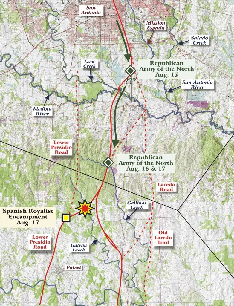 Ted Schwarz and Robert Thonhoff's Recreation of Military Maneuvers Preceding the Battle of Medina, August 18, 1813. Ted Schwarz and Robert Thonhoff's Recreation of Military Maneuvers Preceding the Battle of Medina, August 18, 1813.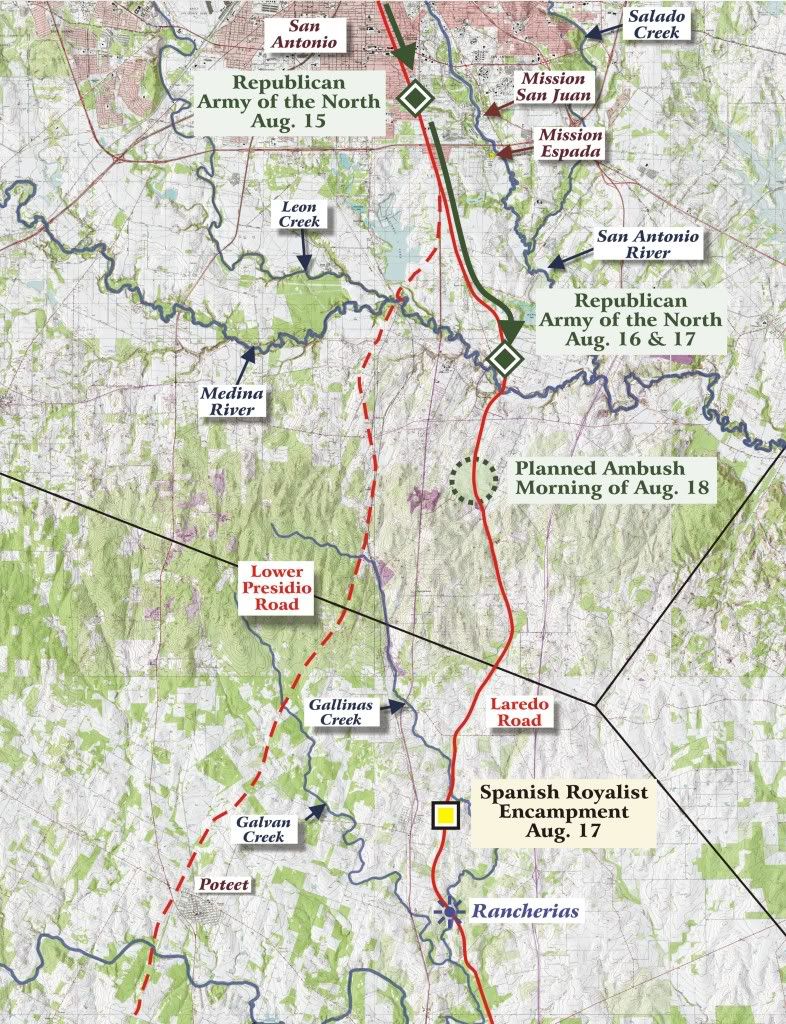 Bruce Moses' Recreation of Military Maneuvers Preceding the Battle of Medina, August 18, 1813. Bruce Moses' Recreation of Military Maneuvers Preceding the Battle of Medina, August 18, 1813. |
|
|
|
Post by Kevin Young on Jan 18, 2010 10:59:12 GMT -5
Very interesting and the map comparison is great! Looking forward to more. Thanks!
|
|
|
|
Post by savethealamo on Jan 28, 2010 23:50:24 GMT -5
While the artifacts in Steve Ash's possession are questionable, the location of his place in relation to Jose Antonio Navarro's and Agua Negra Road, and the location of the Gallinas Creek on a pre-1839 map of Bexar County, does make me wonder if they mistook the Gallinas for the Medina, at a location where it has long since dried up. And then there's that oak tree with the nails in it. And my dowsing rod that reacted near the tree. But I arrived on the scene with no real knowledge of the battle, no pre-conceived ideas of what the experts say, just me, my old maps, my dowsing rods, and my fascination with Centennial markers. I still can't figure out why the call came when I was sitting in the GLO, where I had no intention of being that day. Sure I may be proven dead wrong, it won't be the first time!
|
|


