|
|
Post by bmoses on Nov 9, 2007 16:21:24 GMT -5
I'm currently working on a project along Salado Creek in Bexar County and have identified a trace of the Old Gonzales Road within the project area. The road, linking San Antonio and Gonzales, would have crossed two separate channels of the Salado (the Dry or Barranca and Main Salado) and then crossed into the modern Covington and then Comanche Parks. I have written a very brief outline of the history of the road ( in progress- see below). I am wondering if anyone knows of additional details that you would be willing to share regarding this route or events that transpired along it? I plan to delve into specific details related to the actions/routes of Alamo couriers (Sequin, Smith, etc.), Santa Anna, armies, etc. I have also identified a number of Texas veterans lived nearby or owned property in the area following the war. Unfortunately, my deadline is fast approaching (I should have posted this sooner) so thanks in advance to anyone who may be able and willing to assist.
The Old Gonzales Road
Although having a relatively short history compared to the Goliad Road, the Gonzales Road saw a great deal of military activity during the Texas Revolution. The Gonzales Road was originally laid out in 1832 by Erastus “Deaf” Smith by permission of the Mexican authority in San Antonio. The road left San Antonio by way of Alameda Street (today Commerce Street) and forked with the later routes of the Goliad Road near (___). The route continued east to Salado Creek where it crossed into Covington Park and continued eastward crossing Cibolo Creek below its confluence with Martinez Creek.
Within the current project area and adjacent to the Gonzales Road in Covington Park, Stephen F. Austin’s Texian Army camped in preparation for the campaign known as the Siege of Bexar. The Gonzales Road carried Texan troops and couriers to and from the Anglo settlements at Gonzales and beyond prior to and during the Siege of the Alamo. The Gonzales Road also carried two battalions of Santa Anna’s troops, including five pieces of artillery and a month's rations, eastward at the outset of the Runaway Scrape. On March 31, 1836, just 25 days after the fall of the Alamo, Santa Anna and his staff, with General Filisola, departed on this same road.
[/i] |
|
|
|
Post by bmoses on Nov 9, 2007 19:02:38 GMT -5
I have seen a discussion indicating that the couriers may not have taken the main Gonzales Road straight out of Bexar for fear of encountering Mexican scouts. Does that sound valad?
|
|
|
|
Post by Jim Boylston on Nov 9, 2007 21:24:10 GMT -5
I have seen a discussion indicating that the couriers may not have taken the main Gonzales Road straight out of Bexar for fear of encountering Mexican scouts. Does that sound valad? I think it sounds reasonable, Bruce. The Mexicans were certainly aware of the route and were keeping it under observation. I would expect that couriers might have used the route once safely away from Bexar but might have approached it circuitously. Jim |
|
|
|
Post by Allen Wiener on Nov 9, 2007 23:40:34 GMT -5
We had a discussion some time ago about the most likely location at which Alamo couriers exited the fort. I can't find the thread now, but I believe they most likely used the ditches or acequia along the west wall, which may have been deep enough to conceal them, and then found a route out of the area where they were not as likely to be spotted as they would have been on the road. As Jim suggests, they would have picked up the main road later on, once safely away. I'm wondering if this would not, then, automatically become the route back into the Alamo for those couriers who returned and the 32 men from Gonzales as well.
AW
|
|
|
|
Post by TRK on Nov 10, 2007 10:10:00 GMT -5
Sounds like an interesting investigation, Bruce. Is there sound evidence for Deaf Smith as the person who laid out the Old Gonzales Road? In the book Texas by Teran (University of Texas Press, 2000), p. 210, note 6, the editor, John Weat, states that Byrd Lockhart surveyed the road, which stretched from San Antonio de Bexar to San Felipe, and it was completed in 1827. The note includes documentation; an online copy of note 6 is here: books.google.com/books?id=VE5F6dhZ-kEC&pg=PA210&dq=%22old+gonzales+road%22&sig=D7OUQzz4VeNLxPxl8zOXSytIuSgIncidentally, Wheat adds that the road was 65 leagues, or 169 miles, long and was wide enough for wide wagons. Lockhart billed the government 1,000 pesos fee + 400 pesos expenses for the survey; in lieu of his fee, he requested and was granted four leagues of land. |
|
|
|
Post by Herb on Nov 10, 2007 11:55:10 GMT -5
I can't add anything of significance, but obviously this was the route that S. Dickinson took to Gonzales after the fall of the Alamo. It seems that this was the also the route used by Nat Lewis and Dimmet on the first day - at least to to the fork to Goliad where Dimmet broke off.
From reading Sutherland's account on the intended reinforcement he accompanied after the fall of the Alamo - it seems they used the Gonzales Road to Cibolo where they stopped while J.W. Smith scouted toward the Alamo. While it's not mentioned I expect the 32 did something similar.
Also according to Sutherland, the Alamo garrison's horses were kept on the Salado and Travis borrowed a horse from him on the 23rd to send a messenger out to the horse herd. While a specific location is not given - it would seem probable to me that the herd was somewhere near the Gonzales Road crossing site.
Like I said - not much!
|
|
|
|
Post by bmoses on Nov 10, 2007 13:52:47 GMT -5
This is all really great information. Thanks to you all for the input! That is certainly a different take on the origin of the road Tom, I had used information written recently for a local newspaper, it goes to show that you really need to check your sources closely. When the army under Austin first established camp at the Salado in 1835, there was already a Mexican outpost near the fords. I’m sure that all of the main road crossings, especially this one, were watched closely by both armies in 1835 and 1836. Here was Austin’s first order from the Headquarters on the Salado. Head Quarters on the Salado 20th Octr. 1835 To all the Volunteers on the road,
The army took up this position early this morning. The enemies outposts retired before our spies and advance without loss on either side. This position is within less than five miles of Bejar. The enemies out posts are in sight on the top of the hill between this and Bejar. The reinforcements are specially ordered to push on by forced Marches—on this side of the Civolo they ought to march in companies of not less than ten or fifteen. It is particularly enjoined on all the Volunteers who arrive at Gonzales to furnish a guard for the beeves that Mr Kent or Mr. Fuqua are bringing on.
S F. Austin Comr in chief By order Warren D C Hall Adjt Genl. One other question that has been a real puzzle for me and wolfpack touched on above. One of the main resources I have is a detailed survey map created by a W. H. Owen in 1876. The map, entitled “Route of the New Goliad Road” describes this new route as being established in 1854. The map also shows a dotted line crossing the area and calls it the “Presently Traveled Route”. I am pretty sure that this was the route of the Goliad Road during the 1830s and 1840s and it is only a short distance south of the Gonzales Road in the vacinity of the Salado. Now, I am relatively certain that there was an older route of the Goliad Road in use during the Spanish period (and probably even later) that left San Antonio along a more southerly route and crossed the Salado south of the confluence of Salado and Rosillo Creeks. Does anyone know anything about these two different routes of the Goliad Road? |
|
|
|
Post by TRK on Nov 11, 2007 12:45:09 GMT -5
The map also shows a dotted line crossing the area and calls it the “Presently Traveled Route”. I am pretty sure that this was the route of the Goliad Road during the 1830s and 1840s and it is only a short distance south of the Gonzales Road in the vacinity of the Salado. Now, I am relatively certain that there was an older route of the Goliad Road in use during the Spanish period (and probably even later) that left San Antonio along a more southerly route and crossed the Salado south of the confluence of Salado and Rosillo Creeks. Does anyone know anything about these two different routes of the Goliad Road? I haven't seen any 1830s or 1840s maps, or descriptions of routes in the vicinity, that refer to a Goliad road just south of the Gonzales Road in the vicinity of the Salado. The William Grattan map of San Antonio de Bexar at the Newberry Library (See Jack Jackson, ed., Almonte's Texas, 368), which dates to 1835 or 1836, shows two routes labeled "Road to Labahia" (i.e., Goliad) branching off, respectively, to the southeast and to the south, at La Villita. The former route would have entered present S. Alamo Street a bit north of East Nueva Street, while the part of the latter route shown on the Grattan map coincided with South Alamo Street. I believe there was yet another "Goliad Road" that left Bexar and paralleled the west side of the San Antonio River. This is speculation, but perhaps there was in the 1830s a trace or road that paralleled the Gonzales Road almost as far as Salado Creek, then veered south along the creek before meeting up with the Goliad Road (i.e., the one on the east bank of the San Antonio River) some distance south. Such a road down Salado Creek, though it doesn't show up on maps I have access to, would make sense as a means of servicing the ranches in that valley. There were no doubt various traces and crude roads in the area. For example, the Grattan map shows a lesser road labelled "Road to Gonzales" running northeast from the "Road to Labahia," meeting a short branch from the main Gonzales Road, then running parallel to the main Gonzales Road. Unfortunately, the map doesn't show the subsequent route of that lesser road. Edited to add: Concerning the "older route of the Goliad Road in use during the Spanish period (and probably even later) that left San Antonio along a more southerly route and crossed the Salado south of the confluence of Salado and Rosillo Creeks," that route was still in common use as late as 1846. Captain Lorenzo Sitgreaves of the Corps of Topographical Engineers traveled and reported on that route in the summer of 1846, and it was the route that Gen. John E. Wool's army subsequently used in its march from Lavaca to Bexar. Sitgreaves noted the route's landmarks and mileages, and reported that after paralleling the San Antonio River and crossing Salado Creek, it was nine miles to San Antonio de Bexar. Checking a modern map of the area, it is just about nine miles, straight run, from Rosillo Creek to the center of San Antonio, while, for example, it is only about four miles from the city center to the Old Gonzales Road's crossing of the Salado. Thus, it sounds like the La Bahia road Wool's army took was the one that crossed the Salado at Rosillo Creek. [Source: John W. Hughes, Memoir Descriptive of the March of a Division of the United States Army Under Command of General John E. Wool, from San Antonio in Texas to Saltillo, in Mexico (Washington: 1846): 49.] The engraved, fold-out map showing the route of Wool's march accompanying Hughes' report, as well as the manuscript map upon which the engraved map was based (National Archives, RG 77, AMA-106), though both are small in scale, show this Goliad-Bexar road, and it appears to cross Salado Creek in the vicinity of its junction with Rosillo Creek. |
|
|
|
Post by Allen Wiener on Nov 11, 2007 19:27:01 GMT -5
Thanks Tom; that's really detailed. I do have the Jack Jackson Almonte book and I'm looking at the Grattan map on page 368. Even with my trusty magifying glass, I'm having trouble seeing exactly which road is which; all are indicated by dotted lines. The most directly southerly route is labeled "Road to Labahia" (as far as I can tell); the next one up, which is heading in a more southeasterly direction, also appears to be labeled "Road to Labahia"; the third, which is north of these two and heading in an east-northeast direction, appears to be labeled "Road to Gonzalez" and merges into another dotted line, heading pretty much due east, but which is not labeled.
There are two other roads leading out from the street just south of the Alamo, One heads east/northeast; another, which branches off from this, heads north. I can't make out the labels for either of these two roads.
AW
|
|
|
|
Post by TRK on Nov 11, 2007 19:39:11 GMT -5
Allen, I'm away from my books, but the one road heading north from the center of the town was labeled "Road to Mina." I'll see if I can decipher the other one(s) tomorrow.
|
|
|
|
Post by TRK on Nov 12, 2007 10:03:01 GMT -5
There are two other roads leading out from the street just south of the Alamo, One heads east/northeast; another, which branches off from this, heads north. I can't make out the labels for either of these two roads. OK, the one that branches north is labeled "Road to the head of the river] (i.e., San Antonio River), and the one heading east/northeast is "road to the [illegible]". The illegible word could possibly be "north," but it's unclear. In comparison, the Morgan W. Merrick map of the siege of Bexar, made in or around 1853 (DRT Library), shows two roads or trails branching out of the north and south sides of the Alamo compound, forming a junction just east of the Alamo, and then continuing as one route east. He labeled this "Nacogdoches Road." Also, the map captioned "1837 land ownership around San Antonio" in George Nelson, The Alamo: An Illustrated History, 1st ed., p. 26, shows a similar road branching off northeast from the Alamo, labeled "Camina [ sic] de Nacogdoches." So, the road in the Grattan map heading north by east from the Alamo probably was equivalent to the old route to Nacogdoches. |
|
|
|
Post by bmoses on Nov 13, 2007 11:55:25 GMT -5
Republic of Texas Army Headquarters on the Salado, Oct. 20-26, 1835On October 2, 1835, a detachment of the Mexican army engaged Anglo settlers in the Mexican Texas town of Gonzales in a skirmish known as the Battle of Gonzales. Although considered a minor military engagement, the event precipitated a break between the American colonists and the Mexican government and is considered the beginning of the Texas Revolution (Hardin 2001). A week and a half later, a small army made up of three hundred volunteers from the Anglo colonies was assembled at Gonzales. On October 13, under the direction of Stephen F. Austin, the Texans departed the town with the objective being the garrisoned town of San Antonio de Béxar. The army moved forward along the Gonzales Road as far as Cibolo Creek, where they encountered a small Mexican scouting party (Barr 1990). The Texans, suspecting an ambush, halted and made Camp near the Cibolo. Word soon arrived from scouts several miles ahead that a strong Mexican picket force had taken up a position along route in the vicinity of Salado Creek (Austin 1907). Austin, desiring to keep the army moving toward San Antonio, dispatched a squad of twenty-five men undercover of night to dislodge the Mexican contingent at the ford. The party entered the Salado drainage some distance below the fords (near modern Comanche Park), tethered their horses and crept forward under the darkness of night along the bank of the creek (Smithwick 1997). One member of the group, Noah Smithwick, later recalled the operation: Occasionally a dry twig would snap with a report seemingly as loud as a pistol shot, and we would pause and hold our breath to listen; but we heard no other sound save the rustling of the fallen leaves, with now and then the dismal hoot of an owl, or long, hungry howl of a wolf - uncanny sounds at any time, and certainly not calculated to cheer us in our critical situation. We knew not how many of the enemy there were, but we knew there were just twenty-five of us and no reinforcements at hand.
At length, when we were nearing the site of the supposed camp, one fellow began to weaken. "Boys," he said in a shaky whisper, "I don't like this. Ef thar's a big force of 'em they'll whop us." Thereupon Conrad Rohrer, a big Pennsylvania Dutchman who never realized the meaning of the word fear, hissed half under breath: "Shet up; don't say they'll weep us; you're weeped already!" The logical inference, so forcibly expressed, provoked a smothered laugh despite the peril in which we stood. A careful reconnaissance failed to discover any enemy, so with lighter hearts - if somewhat heavier steps – we returned to our horses, mounted and galloped back to camp (Smithwick 1997).” Over the next several days, the small Texan army received much needed reinforcements. Three additional companies and two pieces of artillery arrived at the Cibolo camp. The army’s strength was increased to around 450 men by the time Austin was prepared to continue on toward San Antonio (Barr 1990). Early on the morning of October 20, Austin sent out a small squad of hand picked men to lead an advance scouting operation in the direction of the Salado (McKeehan 2003a). Evidence of a Mexican presence along the Gonzales was abundant and soon a group of Mexican foragers was encountered at the Salado. Creed Taylor, a member of the advanced guard reported: …we came in sight of the foragers at the river and opened fire. The Mexicans were greatly surprised and after an exchange of shots fled in confusion. We gave hot pursuit for two or three miles, and in the running fight Henry Karnes killed one, and another was captured. The captive had his horse killed under him in the first fire at the Salado, and as his horse fell he sustained severe bruises at the knee and was unable to flee with his comrades. In the melee the Mexicans had left several horses, stampeded during the skirmish and it was while rounding up these animals that the wounded man was discovered (McKeehan 2003a). The scouts took control of the Salado crossings as Austin moved army forward and established camp on the east bank of the Salado in the vicinity of modern Covington Park (McKeehan 2003b). Jim Bowie had joined the army on the grassy plain between the Cibolo and the Salado and was immediately given a position on the staff. As the main body of the army approached the Gonzales Road crossing of Salado Creek on the morning of October 20, the advanced-guard encountered Mexican cavalry at the ford. Shots were exchanged by both sides but the Mexicans retired to a ridge on the west bank of the creek where they maintained a look out post for the remainder of the day (McKeehan 2003b). One of Austin’s first orders from the new camp was addressed to all volunteers continuing to make their way westward along the Gonzales road: Head Quarters on the Salado 20th Octr. 1835 To all the Volunteers on the road,
The army took up this position early this morning. The enemies outposts retired before our spies and advance without loss on either side. This position is within less than five miles of Bejar. The enemies out posts are in sight on the top of the hill between this and Bejar. The reinforcements are specially ordered to push on by forced Marches—on this side of the Civolo they ought to march in companies of not less than ten or fifteen. It is particularly enjoined on all the Volunteers who arrive at Gonzales to furnish a guard for the beeves that Mr. Kent or Mr. Fuqua are bringing on.
S F. Austin Comr in chief By order Warren D C Hall Adjt Genl. (Austin 1907). General Cos, learning that the Texan Army was now encamped on the outskirts of town, pulled his troops back and began preparing a strong defensive position inside the town and at the Alamo garrison (Winders 2004). Both the Texans and Mexicans received much needed reinforcements during the week. Approximately 135 Mexican Texans led by Juan Seguín entered the Camp on the Salado on October 22 (de la Teja, 1991). Recruits also arrived at the camp from Goliad and the ranches and farms south of San Antonio. Seguín later recalled riding into the camp on the Salado with his forces and meeting with Austin: Upon this occasion I had the opportunity to become acquainted with General Sam Houston, who accompanied Austin. On the same day we had a slight engagement with the forces under Cos, who retired into San Antonio. Austin, as Commander-in-Chief of the Army, gave me the appointment of Captain (de la Teja, 1991). Seguín was then sent out to obtain provisions from other Mexican civilians living in the nearby countryside. Austin took advantage of the time at the Salado Camp by drilling the fledgling Texan Army while waiting for additional volunteers and provisions to arrive. General Cos sent out bodies of cavalry to challenge the Texans daily and skirmishes occurred regularly near the Texan’s camp (Winders 2004). Ambrose Rodriguez, a San Antonio resident, kept Austin posted on matters in Béxar (McKeehan 2003a). On October 22, Austin instructed Colonel Bowie along with Captain James Fannin to take the newly formed First Division of the First Battalion (90 men) to reconnoiter south of Béxar in the vicinity of the missions (Austin 1907). The main Texan army remained encamped on the Salado until the twenty-seventh. On October 26, 1835, Bowie and Fannin reported that a small group of Mexican pickets had been encountered at Mission Espada had been driven from the field (Barr 1990). At the suggestion of his two colonels, Austin shifted the Headquarters to Mission Espada, on the San Antonio River, and about ten miles below town. The Texan Army’s former campsite on Salado Creek saw no additional noteworthy action during the remainder of the conflict. ReferencesAustin, S. F. 1907 General Austin’s Order Book for the Campaign of 1835. Southwestern Historical Quarterly Online 11(1). Electronic document, <http://www.tsha.utexas.edu/publications/journals/shq/online/v011/n1/article_5.html>, accessed November 12, 2007. Barr, A. 1990 Texans in Revolt: the Battle for San Antonio, 1835. University of Texas Press, Austin. de la Teja, J. F., ed. 1991 A Revolution Remembered: The Memoirs and Selected Correspondence of Juan N. Seguin. State House Press, Austin. Hardin, S. L. 2001 Battle of Gonzales. Handbook of Texas Online. Electronic document, <http://www.tsha.utexas.edu/handbook/online/articles/GG/qeg3.html>, accessed November 11, 2007. McKeehan, W. L. 2003a Creed Taylor. The March, the Siege and the Battle for Bexar Oct-Dec 1835. Electronic document, <http://www.tamu.edu/ccbn/dewitt/batbexarcreed.htm>, accessed November 12, 2007. 2003b William T. Austin's Account Siege &Battle of Béxar 1844. Muster at Gonzales and Battle of Béxar. Electronic document, <http://www.tamu.edu/ccbn/dewitt/bexaraustinwt.htm>, accessed November 12, 2007. Noah S. 1997 The Evolution of a State or Recollections of Old Texas Days. Electronic document, <http://www.oldcardboard.com/lsj/olbooks/smithwic/otd.htm>, accessed November 12, 2007. Winders, R. B. 2004 Sacrificed at the Alamo: Tragedy and Triumph in the Texas Revolution. State House Press, Abilene.
|
|
|
|
Post by bmoses on Nov 13, 2007 12:16:33 GMT -5
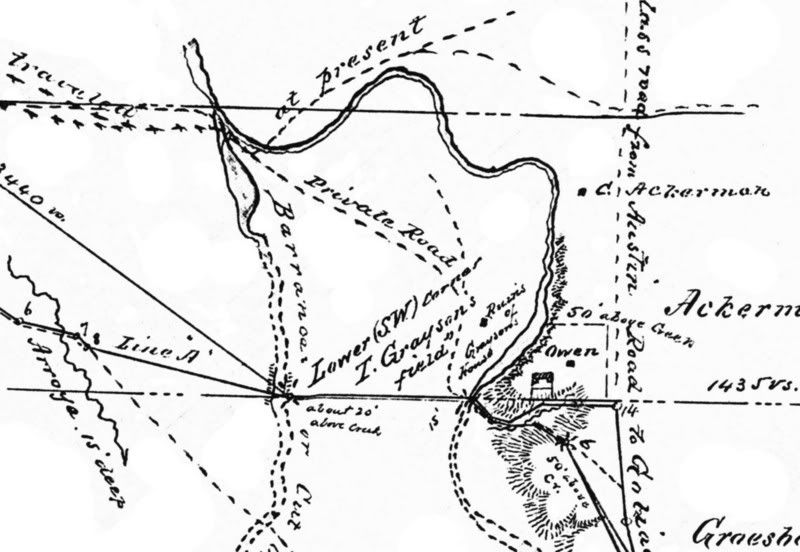
Here is the detail of the 1876 surveyor’s map which I have used to look for a number of the crossings in our current project area. The map, surveyed and drawn by W. H. Owen in 1876, traced the new route of the Goliad Road (established in 1854) from the current vicinity of Roland Avenue and IH-10 to the Bexar/Wilson County Line. In addition to the route of the “New Goliad Road”, Owen noted other routes and landmarks of historical significance including ranchos, waterholes, ruins, homesteads and cemeteries. The label for the Gonzales road has been cut off in this view but it does show up to the left on the full version. Here, the road is marked by the label "traveled at present". Notice that their are two crossings shown. The first is of the barranca or cut-off and the second is of the main Salado channel. Also note that the "Ruins of Grayson's house" are in fact those of Thomas Wigg Grayson, a shipowner who played an important role in the naval operations of the Texas Revolution. I had also included a note in the map in the previous post relating to Manuel De Mier Y Téran's camp on the Salado, but failed to mention it in my summary of the Camp. Here is a brief description of the area near the Salado as recorded by Téran in the Spring of 1828. Sunday, April 13, 1828
At 4:01 PM., departure from Béjar: 15-minute stop at the guard post. At 5 P.M. arrival at the Salado (Creek). One league of level road east through the hills: vegetation very thick with grasses and plants of the genus gaura and verbena, and a liliaceous plant that senior Berlandier called narciso. Camp on the west bank of the Arroyo del Salado. This is small stream runs deep between two small hills. Along its entire length there is a forest of oak, pecan, plum, elm? and cottonwood trees. Its source is to the northwest of Béjar, six leagues from this site on the Salado, and it flows into the Béjar (San Antonio) River one-half league above the Espada Mission.
At night much calling of the local tiburón, rana taurina (bullfrog), singing of owls, and another very strange song that sounded like a cuckoo to Mr. Berlandier.
Monday, the 14th
From the Arroyo Del Salado to the Cibolo. From 7:25 until 1:25 we traveled through the hills. In crossing the valleys they form, there are streambeds so deep and narrow that they are very dangerous for the carriages. It is said that the North Americans have opened the road, but there is scarcely more than a path and distances markings on the trees (Jackson 2000). ReferenceJackson, J., ed. 2000 Texas by Terán: The Diary Kept by General Manuel de Mier y Terán on His 1828 Inspection of Texas. University of Texas Press, Austin. |
|
|
|
Post by bmoses on Nov 14, 2007 10:04:11 GMT -5
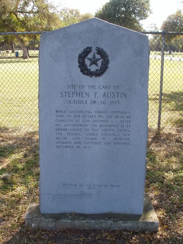
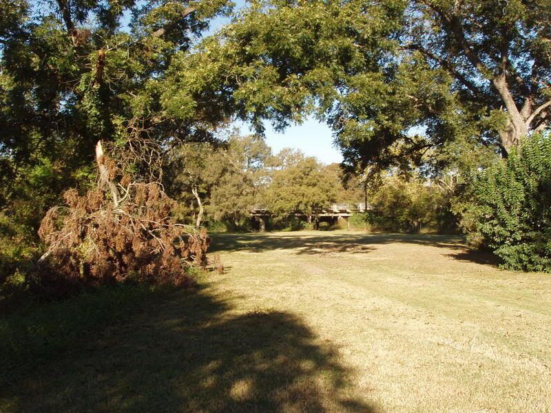
Two images of the area of Austin's Headquarters on the Salado as it looks today. The first photo shows the Texas Centennial Marker erected at the site in 1936. The second image was taken on the west bank of the Salado just north of the Gonzales Road fords and shows the general area of the Texan’s Camp. The Rigsby Avenue Bridge over the Salado can be seen in the background. Although the camp is generally recognized as being inside Covington Park, the specific location and layout of the camp has not been archaeologically determined. |
|