|
|
Post by Allen Wiener on Apr 1, 2011 8:45:45 GMT -5
I notice (again) the "L" shape of the northwest corner, where the north and west walls do not join neatly to form an angle, but leave a kind of opening. As I recall, this is seen on many plats and maps of the Alamo ca. 1836, but not in most models I've seen of the compound. Was that really there?
|
|
|
|
Post by Jim Boylston on Apr 1, 2011 11:10:09 GMT -5
I notice (again) the "L" shape of the northwest corner, where the north and west walls do not join neatly to form an angle, but leave a kind of opening. As I recall, this is seen on many plats and maps of the Alamo ca. 1836, but not in most models I've seen of the compound. Was that really there? Isn't that the space where the house in the NW corner was leveled? |
|
|
|
Post by Allen Wiener on Apr 1, 2011 11:40:43 GMT -5
Could be, but was it there during the battle and leveled later on, thus showing up in this configuration on the plat?
Incidentally, George Nelson (who says he spent 28 years, off and on, researching his book, has the "gap" or "L" shaped feature I'm talking about, but I think some archeologists say it was not there during the battle; that there was a house completing the corner there.
Allen
|
|
|
|
Post by Jake on Apr 1, 2011 13:21:30 GMT -5
Stuart: Those two points are the edges of pilasters that frame the main south gate. We actually have some contemporary drawings by dependable (relatively) artists who show that the gateway is flat-topped, not arched. The size of the points are somewhat exaggerated on the Giraud plats.
Jim and Allan: Here's a bit of my own discussion about the northwest corner for you.
Both the northwest and southwest corner gun platforms were (apparentl) built in 1835 using the walls of the houses here. Both were destroyed after the battle. The Losoya house at the southwest corner was rebuilt, approximately but not all that precisely on its original foundation, but the northwest corner was not rebuilt, leaving the gap of the missing corner.
Inexplicably, questions have been raised about the honesty of Giraud’s survey of the Maverick properties. In 1959, writer Charles Ramsdell argued that Giraud was a crony of Maverick’s, and had carried out the survey in such a way as to give Maverick portions of the Plaza illegitimately, so that he could build his house within the Plaza boundaries; Ramsdell implied that Maverick was a “squatter.” [Ramsdell, San Antonio, p. 86.] “Giraud obliged his friend by cutting off a northwest corner and the entire corral on the northeast, and making the boundary the inner line of the buildings around the wall instead of their outer line . . . Maverick’s house was built in the northwest angle, well within the old walls.” [Ramsdell, San Antonio, p. 86.] This suggestion of some sort of impropriety was repeated by archaeologist Feris Bass, who said that Maverick persuaded Giraud to “modify his survey to permit Maverick to acquire some of the Alamo property.” [Fox, Bass, and Hester, Alamo Plaza, p. 18.] Even Susan Schoelwer echoed the story: Giraud’s map had “a curious rectangular indentation in the northwest corner of the outer wall. This indentation, which is not corroborated or explained by any other contemporary source, marks the eventual location of Maverick’s house and was evidently created for his benefit.” [Schoelwer, “Artist’s Alamo,” p. 453.]
Ramsdell and more recent Maverick critics seem to be operating under the impression that no private individual could own any property within the walls of the Alamo; this was presumably associated with the debate between the city, the Army, and the Church over who owned the Alamo property. But as the brief outline above of his purchases indicates, Maverick bought houses and land around Alamo Plaza long before the U.S. Army arrived and Giraud’s survey was conducted. Giraud “permitted Maverick to acquire” nothing; he surveyed what Maverick had purchased from the legal owners nine years before – property and structures clearly described in their deeds to him. Of course the survey ran along the inner faces of the buildings along the north end of the Plaza – they were the buildings he had bought, and were therefore within his property line.
Giraud mapped an empty rectangular notch in the northwest corner because of two reasons. One was that the structures in this area had already been destroyed by the beginning of construction of the new Maverick house. But this had been an area of confusion where the surviving physical evidence was open to several interpretations even before the demolition of the northern Castañeda house in the 1840s. Everett, for example, in 1846 showed the buildings along the west wall ending short of the northwest corner, as does Giraud, but Everett showed by dotted lines that he thought the outer, not the inner, wall continued to enclose the original corner. F.E.B. recorded no wall traces at all in this area. The destruction of the gun platform simply removed the northernmost room in the corner, leaving the structural traces unclear.
Maverick had purchased the northwest corner area as part of the Castañeda lot, and regardless of where the outside wall went, his land ran to the inner corner. Ramsdell’s criticism of Maverick and Giraud was based on ignorance of the original deeds and a peculiarly human urge to find conspiracy; the subsequent authors who repeated the story were simply accepting Ramsdell’s opinion without sufficiently checking the original record.
|
|
|
|
Post by Joy Manuel on Apr 1, 2011 13:22:21 GMT -5
Jake, Thank you for the write-up and the maps this is marvelous.
Joy
|
|
|
|
Post by Allen Wiener on Apr 1, 2011 14:19:49 GMT -5
Many thanks for that explanation, Jake. That clarifies things; very interesting history to that place.
|
|
|
|
Post by Jake on Apr 5, 2011 12:02:04 GMT -5
The Book is up on the San Antonio City website, for those of you who want to look: www.sanantonio.gov/clerk/ArchiveSearch/AdvancedSearch.aspxTo find it you go to the big box listing the collections at the bottom of the page, scroll down and check the "City Engineers Maps 1884-1901," then go up to Advanced Search, and in "Search Field" click the down arrow and select "Page #", then in "Condition" select "equals", and in "Search Phrase" type the page number you want, and click "Search" at the bottom of the page. This gives you a list of possible pages you might be looking for. The list is more or less by date, with oldest at the bottom, and the indication that it's The Book is "Survey Book 1" and the statement that this listing is for page "something" of 478. Note that the pages as indexed seem to be one number high -- for example, if you want the page with "52" stamped on the upper corner, you have to request p. 53. This is odd, but archivists have reasons for these things that regular mortals do not ken. P. 53 (p. 52 printed on the corner) is of interest because it has Giraud's survey and plat of the lot of the barracks of the Presidio of San Antonio on it. You can do a simpler and broader search up in the "Simple Search" block near the top of the page. For example, you can type in "giraud" and "maverick" (you need the quotation marks and the "and" without quotation marks for it to work), hit the search button within that block, and it will give you a list where both of those terms appear together on a page. Note that you have to clear all the search terms in the "Advanced Search" for this to work. This brings up a number of listings, one of which is "ALAMO PROPERTY PLAT AND FIELD NOTES-Page 1 of 2," where p. 1 is the 1885 Maverick map I described and you saw in the picture in the original article on mySA, and p. 2 is the 1914 version I showed you. I forgot to mention that the 1914 version has the more recent streets and the post office sketched in lightly on it. The original plat drawing of 1849 by Giraud has been flattened out and put back together (what's left of it), and is now easily recognizable in the color version as the same plat as reproduced in the 1885 and 1914 redrawings. It's on "Subdivision, Civil Engineer, Survey Book 1-Page 115 of 478," (p. 114 is stamped on the corner of the page) and looking good. Simplest of all is, once you have a page image of The Book up on the screen, there's navigation tools at the bottom that let you go forward or backward page by page, or jump to some other specific page number. |
|
|
|
Post by TRK on Apr 5, 2011 15:07:46 GMT -5
Fun! Now to see if there are any drawings by Giraud of the southern part of La Villita--anything that shows the area of where the Cuartel was located. Or the site of the Powderhouse. Or....
|
|
|
|
Post by Jake on Apr 6, 2011 11:02:05 GMT -5
Tom, Bruce had posted a photo/map of La Villita with the Cuartel marked on it, but I can't find it now. What happened to it?
|
|
|
|
Post by TRK on Apr 6, 2011 12:16:19 GMT -5
|
|
|
|
Post by bmoses on Apr 6, 2011 14:55:12 GMT -5
I can't believe how easy it is to miss something when you're away for a couple of days. A special thanks to Jake (along with Tom, Stuart, Allen, Hiram, Jim and others) for adding this information about the surveying history of Alamo Plaza. The information contained on these pages warrants a special bookmark for me as so many questions are answered, especially regarding Francois Giraud and his role in San Antonio's history. I’m not sure if it was mentioned in the earlier posts, but besides serving as city engineer, Francois Giraud also served as mayor of San Antonio from 1872 to 1875. In 1852, Giraud sought to preserve land around San Pedro Springs for a public park, (now San Pedro Park) – the nation’s second oldest public park after Boston Common in Boston. Below is a photograph of Francois Giraud. 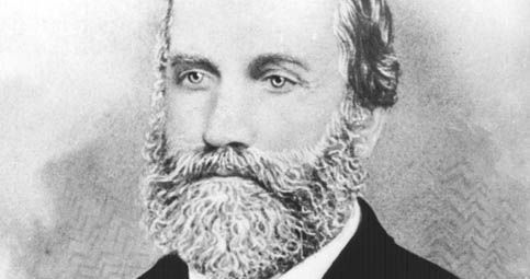 Jake - I do have one other brief question about Giraud that perhaps you can answer, even in an off-site e-mail as it’s probably not relevant to most viewers on this site. Do you know anything about Francois Giraud's son who was also a City Engineer in San Antonio at the end of the nineteenth century? I know that he had four sons, Francois M., Louis T., Leon J. and Eugene A. Giraud, but I’m not sure which one served in this capacity. |
|
|
|
Post by tmdreb on Apr 6, 2011 23:06:17 GMT -5
Giraud's 1852 survey of the city still has influence today.
|
|
|
|
Post by Jake on Apr 7, 2011 16:13:39 GMT -5
Bruce: No need to go off-site, since the answer is "I don't know."
|
|
|
|
Post by Jake on Apr 7, 2011 16:27:29 GMT -5
Tom, your mention of the Cuartel reminds me that the 200th anniversary of the Casas Revolt, that began in the La Villita Cuartel, was on January 21 of this year.
Bruce, there is a brief biography of Giraud in the Alamo Library: Emily Edwards and Mary C. Newell, F. Giraud and San Antonio (San Antonio: Southwest Craft Center, 1985). They will probably discuss what became of his sons, at least briefly.
|
|
|
|
Post by cantador4u on Apr 9, 2011 12:57:30 GMT -5
I'm sure others have been looking through the old survey maps and field notes also. I've found a few things I thought I would share. Follow Jake's directions to get to the city records site, make sure you check the box for City Engineers Maps 1884-1901. You can enter the page numbers in the simple search field (eg. page 118) and it will show the page in the search results at the bottom of the page.
Here's what I've found:
Page 115 - The original Giraud Alamo plat and field notes. The map is in horrible condition but the notes are OK and they extend to page 116 1849
Page 118 - Plat and field notes for the SW corner of the Alamo showing the Charli house, the south wall of the Alamo and the main gate, and the Losoya house. 1849
Page 223 - The Veramendi house.
Some other pages not so exciting but on the Alamo plaza
Page 10 - portion of the East side of the Alamo Plaza
Page 19 - The west side of the Alamo Plaza, continues on page 20 1848
Page 261 - The SE corner of the plaza 1854
Page 271 - Shows the SW corner of the Maverick homestead
Page 245 - Another reference to the Losoya house. 1850
Page 346 - Newly adopted west line of the Alamo plaza and shows the Market house. 1881
- Paul Meske, Sun Prairie, Wisconsin
|
|


