Jake wrote the following and furnished the images:
* * * * * * *
We will begin with The Book.
The surveyor François P. Giraud moved to San Antonio from New Orleans in early 1847, and stayed in Anton Lockmar’s boarding house on Dolorosa Street on his arrival in the city. After Lockmar’s death in 1848, Giraud married his widow, Polinaria Treviño, in 1849, and became owner of the boarding house himself.
Giraud began working as a surveyor in San Antonio during 1847, and first appears in the San Antonio deed and survey books as “Deputy Surveyor” for the city in May of that year. He became City Surveyor in March, 1848, and during 1848 he “surveyed and established the boundaries for the missions.”
The City Survey Book that he began compiling was the official record of all the plats he made of individual properties needing a plat and field notes as part of their transfer or to clear up a dispute of boundaries or ownership. The book contained a large number of plans, and continued to be used by subsequent City Surveyors. Such plans as several of the lots in La Villita or the plan of the lot on which the San Antonio Presidio barracks stood are recorded in the book. But of interest to us right now are the plats in the book of Alamo Plaza properties.
In 1849 he began a series of surveys that entirely mapped Alamo Plaza, carrying out surveys for Samuel Maverick, other land owners around the Plaza, and the U. S. Army to make an accurate plan of the Plaza and its buildings. We do not have Giraud’s files, only the individual surveys as they were recorded on various plats and elsewhere in the official records. Undoubtedly Giraud had a mass of material dealing with his survey work around Alamo Plaza, and there must have been one or several master plans on which he recorded all the information of his field work on the Alamo. The evidence of his available plans suggests that he carried out a complete survey of Alamo Plaza as it was in 1849-1850, although we do not have a copy of that particular plan and field notes.
Of the individual plats and their survey notes that we do have, the most familiar to Alamo researchers like us is the Maverick survey. For this survey, we have the survey notes written by Giraud himself in City Survey Book 1, pp. 114-115. Giraud’s original plat, included in the book, was drawn on what appears to be thin tracing paper, probably traced from a reduced version of the original plan, and glued onto page 114.
Figure 1: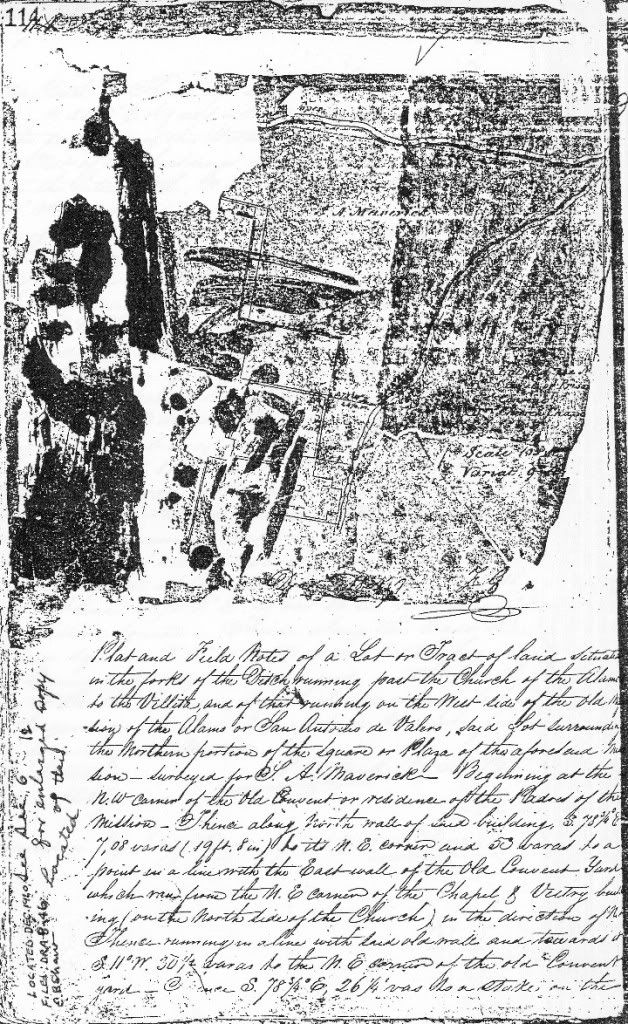
When it was xeroxed, apparently sometime in the 1980s by the county archivist John O Leal, the Maverick survey was brittle, torn, and folded, and the glue had darkened to the point that it made the surviving lettering difficult to read in the xerox. The xerox was kept for some time in the County Deed Records, and is now in the Bexár County Archives in the Bexár County Courthouse, where Albert Rodriguez has everything nice and safe. The original book was later reported as being kept in the office of a city official, and disappeared shortly afterward – it was thought that the departing city official had unknowingly packed it up and taken it with him. Apparently it was instead placed in storage without being listed or catalogued anywhere. It was relocated about the end of January, 2011.
Figure 2: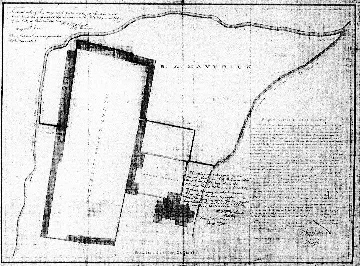
A new, enlarged version of Giraud’s plan of the Maverick survey was redrawn by C.P. Matlock in 1885, and a copy of Giraud’s field notes written onto the sheet. It was originally filed in Case A, Drawer 8, Index no. 46, under Miscellaneous Alamo Property. This is the map scanned and posted on mySA.com, but as you can see, the xerox I have (made from the xerox in the Alamo Library in the 1990s) is of the same map. Based on the mySA story, this map seems to have been inserted into the City Survey Book. Next to the block of field notes written on the map is a certification by C. P. Matlock, the City Engineer: “This plat is enlarged from one on record in City Engineers Office and I hereby certify that the attached field notes are a true copy of those appearing in that record, also that the plat corresponds in every particular with the one recorded, together with the field notes in 1st City Survey Book pp. 114 & 115. C. P. Matlock, City Engineer, San Antonio Texas, Jany 23/85" In the upper left-hand corner of the map is an additional note: “A duplicate of this map with field notes is this day made and filed as a part of the records in the City Engineer’s office of the City of San Antonio Texas. C. P. Matlock, City Engineer, Jany 23d 1885 (Copy of Certificate on map furnished W. H. Maverick).”
Figure 3: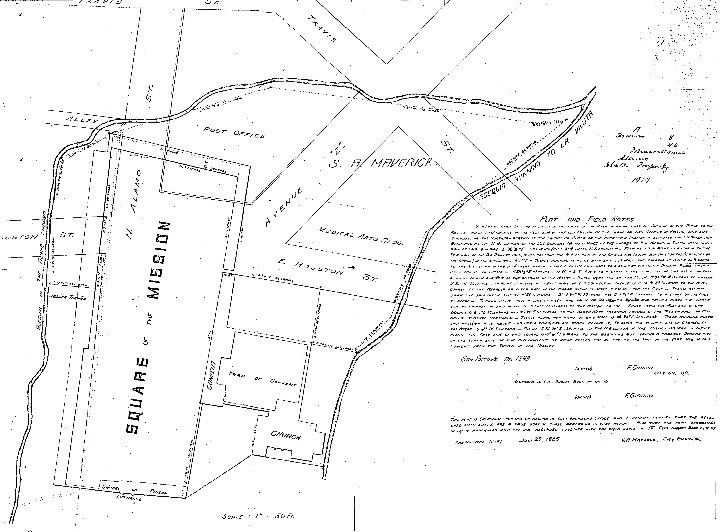
A redrafted copy of this 1885 version was drawn apparently in 1914, and also filed in the City Engineer’s office, also in A, Drawer 8/no. 46, Miscellaneous, Alamo, State’s Property. Giraud’s field notes are in the large block of text on the right, and Matlock’s certification is reproduced just below it in the smaller block of text. This map is probably somewhere in the stored archives of the City Engineer’s office. However, a xerox copy of the 1885 redrawn plan is in the Alamo Library, and a xerox of the 1914 plan is in the files of the Center for Archaeological Research at the University of Texas at San Antonio. A photostat of the 1885 copy is filed as “[Giraud Plat and field notes] copy from office of San Antonio City Engineer,” CN95.163, in the Alamo Library. Thanks to Todd Hansen for informing me of the location of the xeroxed copy of the Survey Book, and the 1885 version of the Maverick Survey.
According to my notes there are differences between the field notes copied on the 1914 plat, the 1885 plat, and the original version written into City Surveyor Book 1. Presumably, the notes written by Giraud himself in the Surveyor Book should be the correct version, but this needs to be confirmed by computer plotting.
There are several other maps of the Alamo Plaza area that were drawn by François Giraud in the period of 1849-1850. Of the two additional full-Plaza plans we have, one is familiar, because it was reproduced in George Nelson, The Alamo: An Illustrated History, (Dry Frio Canyon, Texas: Aldine Press, 1998):
Figure 4: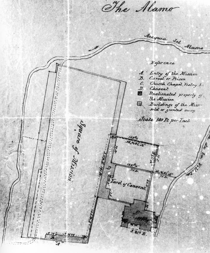
This is what I call the Army Plan, because it was apparently made for the Army as part of a lawsuit between the Army and the city of San Antonio over who owned the buildings around Alamo Plaza. In January, 1850, the United States Army and the Catholic Church reached an interim agreement about the Army's use of the Convento buildings of the mission [Major E.B. Babbitt and B. Callaghan, “Copy of contract for rent of Alamo buildings and grounds. San Antonio,” January 1, 1850, NA, DRT]. Probably included with the agreement was the Army Plan, Giraud’s undated plan showing measurements of parts of the convento and adjoining courtyards, the church, and part of the south gate structure, now usually called the Low Barracks, along the south wall of the Alamo, all structures indicated to belong to the Church on the Giraud Army plan, and mentioned in the rental agreement as included in the lease [François Giraud, “The Alamo,” apparently attached to letter of Major E. B. Babbitt to Major General Joseph S. Jesup, March 19. 1849, NA, DRT. A good copy is in Nelson, Alamo, second revised edition, 1998, p. 67]. The City of San Antonio filed suit for trespass on this land, which they claimed was theirs, on January 29, 1850, but on June 10, 1853, reached an agreement with the Army for a lease of the same property from San Antonio for one dollar per month, beginning July 1, 1853 [Major E.B. Babbitt to General W.C. Buell, August 6, 1853, NA, DRT; Major E.B. Babbitt and Mayor J.M. Devine, June 10, 1853; Colquitt, Message, p. 16].
The two plans, the Maverick survey and the Army Plan, both are obviously redrafts of the same master map, simplified so that each included only details necessary for the particular plat he was drawing. Although we don’t have a copy of that master map, we can get closer than either of the two plats shown above:
Figure 5: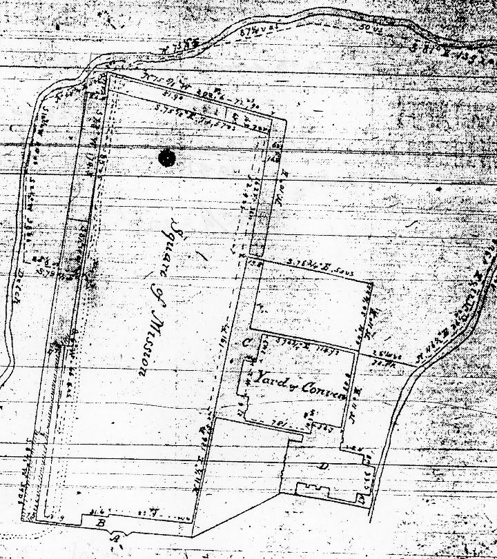
This is the Light Plan, a long-forgotten map of Alamo Plaza that comes close to being Giraud’s original plan of the entire Alamo. This undated plan was drawn about the end of March, 1850, after the Maverick and Army survey plots of December, 1849 and January, 1850. It combines the information from these surveys on a single map, with a few other notes giving us almost enough information to close the southwestern corner. This plan was found in the files of the Bexar Abstract Company early in 1912, and the San Antonio Light printed a fairly legible copy in mid-February of the same year (Figure 3) [San Antonio Light, February 12, 1912, page 2, "Alamo Lines Definitely Established." An original clipping from the Light of this map is in the Daughters of the Republic of Texas (DRT) Library at the Alamo, in the file named “Historic Sites, Alamo, Maps”]. The copy reproduced here is from a microfilm copy of the newspaper, scratches and all – the original newspaper illustration is somewhat more readable.
The Light Plan includes a few notes at the southwest corner, giving some information, much of it confusing, about the southwest corner itself and its relationship to the Low Barracks. It includes measurements along the north side of the Low Barracks building, the same as on the Army Plan, and most importantly of all, and almost unreadable on this copy of the map, it includes the bearing and distance of a survey shot tying the Treviño buildings at the mid-point of the west wall to the Losoya structures at the southwest corner.
Several peculiarities about the San Antonio Light plan suggest that it was a working draft not intended for use with any particular deed. For example, the notations of distance and direction are done in a much less precise handwriting than they are on the finished Maverick and Army plans; and the Light plan records Giraud's uncertainty about the actual lines of the walls on the west side of Alamo Plaza. He plotted two distinct plans of the northern Castañeda house at the north end of the west wall, probably using the partly visible outlines of its surviving foundations, and showed the southern half of the west wall and the southwest corner at two slightly different angles, which placed the southwestern corner and its structures at two different locations about ten feet apart. The two plans diverged at about the middle of the south Castañeda building, a little north of the middle of the west wall. It is as though Giraud was sure of the west wall plan in the area of the southern Castañeda house, but became less sure the farther from this house he got, to the north or south. Along the side of the Charli/Losoya lot at the southwest corner, there is a notation of its length and bearing, S8°40'W, 39 varas (108.3 feet), as well as the distance between the southwestern corner structure and the Low Barracks along the south wall, 48.9 feet.
Figure 6: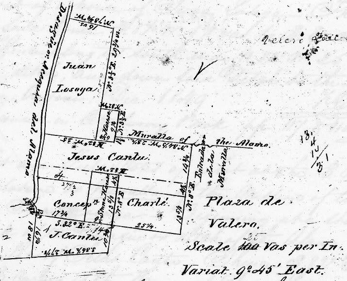
This is Giraud’s plat of the Losoya property at the southwest corner of Alamo Plaza. Details of this survey are in the “Agreement Between Concepcion Charli and Jesus Cantu,” November 28, 1849, BCDR, vol. H1, p. 503, and the “Deed of partition between Concepcion Charli and Juan Losoya,” March 16, 1850, BCDR, vol. I1, p. 13. Giraud’s record plat and field notes are in City Record Book vol. 1, pp. 117-118, and also appear in the deeds of partition.
This plat does not, by itself, have quite enough information on it to tie the Losoya property to the Low Barracks or the southeastern corner of Alamo Plaza, other than measuring lengths on the map and hoping it was drawn to scale. However, when I found the Light Map, the notations Giraud included at the southwest corner, when combined with this, were enough to close the corner.
Figure 7: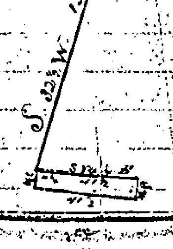
But going the other way, to the east, required this terrible little map drawn into the deed records, and the field notes accompanying it. This is a survey of the Low Barracks building in 1871 by the then-surveyor for the city, C. Hartnett (Bishop C. M. Dubois to the City of San Antonio, W1: 237-238, June 1, 1871). This plan and the associated field notes, when combined with the rest of Giraud’s notes on the Maverick, Army, and Light plans, are enough to make a fairly detailed and apparently quite accurate plan of the Low Barracks.
This last plat and field notes may or may not be in the now-rediscovered City Survey Book – I have never had the chance to look all the way through it to see what is in it, but it’s 474 pages long, so it undoubtedly has a number of things I haven’t seen.
I’ve included these last two plats, the Losoya and Low Barracks plans, because they, combined with the others, do allow, with enough work, the reconstruction of a complete survey of the major lines of Alamo Plaza.
Part of the reason that I say “with enough work” is that each one of the surveys above have one or several errors that have to be worked around – but worse, all of Giraud’s full-Plaza plans share one huge defect Giraud’s familiar map, with its continuous row of buildings along the west wall of the plaza, broad along the north half of the wall and narrow on the south half, is not a representation of the actual appearance of the plan of Alamo Plaza in 1850, or of the fortifications in 1836, or of the original plan of Mission San Antonio de Valero. Giraud’s plan of the west side continuous building is a theoretical plan, nothing more than a guess, and an erroneous guess at that, about the layout of the mission and fort buildings that had stood on the Plaza. The plan shows what Giraud thought the old buildings looked like when the compound was a mission and military post, not what it actually looked like in 1849-1850, as you can easily prove to yourself by looking at the various drawings of Alamo Plaza at this time in Nelson’s book, or Everett’s and F.E.B.’s plans.
Being closely involved with the question of who owned Alamo Plaza and the old mission buildings, and whether the U.S. Army should be paying rent to the City for its use of these buildings, Giraud undoubtedly saw the several plans of the Plaza drawn by Army artist and draftsman Edward Everett. These plans, and the context within which they were drawn, apparently influenced how Giraud recorded his survey information. Giraud was influenced by the same interest in what might prove to be Alamo Fortress buildings that had affected Everett. He followed Everett’s method for dealing with the plan of the structures along the west wall – he, too, showed a theoretical plan of what he thought the Alamo buildings may have looked like based on the visible evidence, rather than an actual plan of the buildings of 1849-1850. Giraud’s map was, in other words, a carefully-surveyed restatement of Everett’s speculative plan.
Even so, the surveys form the armature, the skeleton, of an accurate survey of the Alamo. Using these survey notes and drawings, with enough additional deed work, detailed examination of the Army plans of Alamo Plaza, plans of the standing Alamo structures today and remeasurements of some parts of these, and the archaeology of the Radio Shack and other excavations around the Plaza, an accurate plan of the Alamo can be drawn.


