|
|
Post by Rich Curilla on Oct 31, 2013 0:05:37 GMT -5
Here is a conclusion drawn (several years late) from my virtual model to throw further light on our discussion of the point of view of the Sanchez-Navarro drawing above.  This is the Sanchez-Navarro elevation drawing of the Alamo "from the roof of the Veramendi House."  This is an exact angle of the Alamo on my virtual model with its correct footprint and orientation from the precise location of the the Veramendi Palace, based on my intricate Google Earth overlays. If you click on the picture to blow it up, you will see that the north wall is not seen at all, and we are looking straight at the Alamo church and long barrack, thus totally eliminating the old myth that he is actually showing the long barrack with just the edge of the church visible beyond the right corner.  This angle is precisely the same as my previous picture from the roof of the Veramendi, but now our point of view is from several hundred feet straight up in the air. The side to side perspective of the Alamo is the same as is our distance. Once again notice how impossible it would have been to see the north wall from this point of view 1800 feet due west of the eighteen-pounder. Thus, assuming Sanchez-Navarro did indeed draw his sketch for this elevation while sitting on the roof of the Veramendi Palace, then he had to have taken creative license to show the north wall perspective as well. To get his view of the north wall, he needed to be at least 1,000 feet north on Soledad, near the river bend. |
|
|
|
Post by Herb on Oct 31, 2013 8:36:51 GMT -5
Rich, seems to me a pretty important presentation, though I'm not sure what conclusions we can reach. It seems to me that he must have drawn something from this angle but not the drawing we have today. The church & Long Barracks seem to match up pretty well, but everything else is so skewed it can't be from the same perspective. I can't help but think, that he did a few sketches from different perspectives then combined them in a detailed drawing done later, to complement his "plat". Just thinking out loud.
|
|
|
|
Post by Rich Curilla on Oct 31, 2013 12:15:35 GMT -5
Rich, seems to me a pretty important presentation, though I'm not sure what conclusions we can reach. It seems to me that he must have drawn something from this angle but not the drawing we have today. The church & Long Barracks seem to match up pretty well, but everything else is so skewed it can't be from the same perspective. I can't help but think, that he did a few sketches from different perspectives then combined them in a detailed drawing done later, to complement his "plat". Just thinking out loud. That's the best conclusion I've heard yet. Never thought of more than one drawing, just more than one point of view. Regarding the multiple-angle drawing, if he was indeed trying to demonstrate the fortifications, it would behoove him to ignore reality a bit and make one drawing serve all. We, of course, have never had the opportunity of seeing his original, just this copy that may have been done by a professional artist and not S-N. -- after his sketch(es). This would also account for the plat doing the Corenblith thing with the church and the long barrack line-up. If the sketches had no shading and were done from 1,800 feet away, a new artist would never have known about the church's relative distance behind the long barrack. If the plat was drawn from the elevation instead of the other way around, it could account for this. Of course, we still have the hand-drawn plat from 1836 that seems to have been actually done by S-N, and that makes the same error, so maybe not. So perhaps S-N never retouched his on-site drawing and drew the map later, forgetting the relationship. Oh well, lunchtime!  |
|
|
|
Post by Rich Curilla on Oct 31, 2013 15:14:05 GMT -5
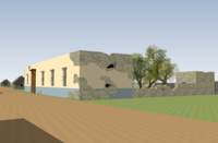
 The Veramendi Palace on my virtual model. This is from 19th. century photographs and the Merrick drawings. The exact footprint of the building and lot going down to the river is from the 1885 Sanborn real estate map and placed over a Google Earth satellite image, and specific measurements are thanks to Mike Harris.  In this high angle from the north, you can see the palace's relationship to Soledad Street as well as General Cos' cannon battery at the far end where the street enters Plaza de las Islas. La Villita in the distance in the left background.  A rear view of the palace, garden and yard from the Milam Sniper Tree across the river on the exact location of the cypress still there and claiming to be the tree. |
|
|
|
Post by davidpenrod on Oct 31, 2013 17:02:05 GMT -5
Herb, I have to disagree with you about Sanchez-Navarro's point of view. Clearly, he was not standing on or near the Veramendi palace when he executed his drawing. In it, you can see the north walls of the church and the north walls of the Convento's second story rooms. In Rich's computer model, you cannot see these features. You can only see the southern walls of the church, the Convento, and the entire "connecting wall" of the Convento courtyard. Furthermore, in the Sanchez Navarro drawing, the viewer's perspective is lower than the Alamo - as if the artist was standing in the river bed and not on top of a roof. I think Sanchez-Navarro drew the sketch somewhere north of the Veramendi palace near the bend of the SA River.
|
|
|
|
Post by Herb on Oct 31, 2013 21:51:47 GMT -5
Must not have been clear, I suggested multiple sketches, combined at a later date into the detailed "elevation" drawing. Just an idea. I think Rich's presentation shows pretty convincingly that the final product was not drawn from the Veramindi House.
One other note from Rich's presentation is how obvious the Charli House is as a "blind spot" in the defenses. Seems to me, that this points to Morales' use of it was a deliberate plan.
|
|
|
|
Post by davidpenrod on Nov 1, 2013 10:34:53 GMT -5
Herb, I think you're right about multiple sketches. He probably made a series of them as part of a reconnaissance from the northwest. If my conjecture is true (and its pure speculation, of course, but that's half the fun of Alamo "studies", isn't it?), I think he prepared them for Gen. Cos and the officers of his column. Its focus is the Alamo's northwest corner and its structures, which were Cos' objectives. It also depicts the ground near and around the walls there, thus providing a limited description of the terrain the column's men would have negotiate while gaining entry to the fort. Of course, as I said, this is pure speculation on my part and there is no supporting documentation for it. The only thing we really know is that Sanchez-Navarro drew a map and a view of the walls and that's it.
Something else that has always fascinated me is that the drawing depicts the exterior walls on the west, but nothing of the Alamo's interior - and its rendition of the church, both in sketch and map, is wholly inaccurate. It doesn't appear that Sanchez-Navarro was ever actually inside the Alamo.
Anyway, I don't think his published drawing was meant to reflect a composite of several drawings from multiple points of view along the length of the west wall. It's perspective is consistent with sketches from the northwest of the compound. I think the only way he could have seen the southern tip of the Main Gate's external fortifications was by moving south along the river.
|
|
|
|
Post by Rich Curilla on Nov 1, 2013 17:32:05 GMT -5
In truth, there was no real angle from which both the north wall and the full face of the church could have been seen. So, either way, there was major license taken (or total ignorance at play) with the drawing as printed. I favor the concept of several degrees of separation from S-N's on-site observations -- whether by another later artist-cartographer or lack of clear memory on the part of S-N in reproducing whatever he did as sketch(es) while under the intense pressure of the moment. It must also be remembered that all people don't see and recall alike. I grew up drawing pictures of the Alamo church facade. I doubt if Sanchez-Navarro did. To him, it was just a building of military value -- or non-value. I've also had the same speculation that he never was inside, but I doubt if that was the case -- just that he didn't pay a lot of attention to details we are now focused on.
When I can, I'll plot out an angle on the model to replicate his north wall view and see what the church-convento relationship looks like from there as well as the south end.
|
|
|
|
Post by Herb on Nov 1, 2013 22:40:58 GMT -5
Going far afield here, but something I commented some months ago to Jake Ivey in a PM, is that EVERY single known error in S-N's work, makes the Alamo appear as a stronger fortress than it was. Not suggesting anything sinister, just one of the oldest problems in first hand military accounts, of the author making a good story better.
|
|
|
|
Post by Rich Curilla on Nov 2, 2013 4:51:40 GMT -5
Going far afield here, but something I commented some months ago to Jake Ivey in a PM, is that EVERY single known error in S-N's work, makes the Alamo appear as a stronger fortress than it was. Not suggesting anything sinister, just one of the oldest problems in first hand military accounts, of the author making a good story better. Very interesting observation. It's certainly true. I wonder if he was motivated to do so by a political goal or need -- like to make the victory appear to have been even harder to achieve. It sure was evident when I looked at my own picture of the virtual Alamo -- constructed according to every measurement we have. It's spread all over creation, and NONE of it appears formidable! With Sanchez-Navarro, it is very compact, and all of it does. |
|
|
|
Post by Rich Curilla on Nov 21, 2013 2:19:37 GMT -5
  Two angles of my Veramendi Palace -- the first with Juan Navarro Alsbury talking to Santiago Bowie (in the sala). The third picture (which I entered just like the other two and yet it chose to lodge itself on the bottom and label itself an "attachment")... The third picture is from behind Cos' battery at the entrance to the plaza. It is aimed up Soledad Street at the Veramendi house exactly 100 yards north. Attachments:
|
|
|
|
Post by Rich Curilla on Nov 22, 2013 2:19:41 GMT -5
 Looking north at the Veramendi house. With General Cos' batteries pounding it during the Battle of Bexar from 100 yards to the south at the street battery, 700 yards to the east at the Alamo, 200 yards from the roof of the church and 275 yards from the N.W. corner of Plaza de Armas on the west, it would have been impossible for the house to have avoided severe damage. The upper hole in the south wall here and the damage sustained by the garden wall are from such cannon fire. The lower hole was knocked out from inside by Johnson's men after daylight on December 5 as a loophole for Texian rifle fire. |
|
|
|
Post by Rich Curilla on Nov 24, 2013 15:54:39 GMT -5
 Here are three shots of the angles of Gen. Cos' cannonade against the Veramendi house and the Antonio de la Garza house. Since the photos refuse to stay where I place them (I tried four times) for one by one captioning, I'll have to do it all at once! The first photo is looking from the cannon that MAY have been on the roof of the church. Primary accounts vary. It is said variously that there were two cannon or one cannon on the roof of the church or in the "atrium" of the church or also that the cannon on the roof were never placed. If they were, then they had a clear shot at both houses (De la Garza is the other damaged stone house to the left of the Veramendi) -- at point-blank range. The second image is from the west battery that was reported as being behind the farthest building west on the north side of Plaza de Armas. William Corner's 1890 map noting the Battle of Bexar calls this house Padre Maines'. He was the priest who served as chaplain to the local presidiales in 1835 and subbed for Refugio de la Garza occasionally at San Fernando. This labeling of the house (right or wrong in 1890) seems to be responsible for it being considered the "Priest's House," which was a major stepping stone to the Texians in December for breaching the plaza. I do not, at this point, believe this was the time-honored Priest's House. However, there does seem to have been a Mexican emplacement there facing north and east. Veramendi and Antonio de la Garza houses seen in the distance. The third picture is the Alamo (in an early stage of my model development). We are looking at it from the west. Both the S.W. cannon battery (where the Texians later emplaced the 18 pounder) and other cannon ports along the west wall were aimed directly at the rear of the Veramendi house. Texians reported that Cos raised a Red Flag over the Alamo during the Battle of Bexar -- of course one account said a "Black Flag." Red's cooler. Attachments:

|
|
|
|
Post by Rich Curilla on Nov 24, 2013 16:24:30 GMT -5
Thus, to conclude this segment on it's embattled circumstances, the house of Don Juan Martin de Veramendi was not a healthy place to be between December 5 and December 9, 1835. Attachments:
|
|
|
|
Post by edward on Nov 25, 2013 0:57:47 GMT -5
Another transformation from my 2D City layout to 3D.
South portion of building (West face): bearing N 11.5° W, (North portion West face) N 9° W, North face of 'L' building bearing N 87.5° E 26.25 vrs, North Fence Portion N 85° E 59.25 vrs to edge of river. (City survey Book 1, pg 222)
 |
|


