|
|
Post by bmoses on Sept 23, 2009 8:42:34 GMT -5
 Map Legend Map Legend
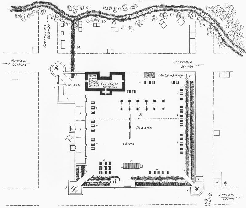
A. Southeast Blockhouse. The cannon from this angle commands the entrance to town from Refugio on the streets south and east of the fort. B. A Blockhouse in progress. C. Magazine D. Northwest Blockhouse commands the river crossing north of the town, the ditch and ravine at east. E. The Watering place. F. Workshop to be strengthened on the top and a cannon mounted. G. Coach House of Savariego, the late commandant – demolished. H. Madam Garcia’s House, new and very strongly built. A platform to be laid from this house to ‘ A’ and a six pounder mounted on the roof which commands the river crossing and road from Victoria, the Refugio road and ¾ of the radius of the country northeast and southeast. I., K., & L. Outhouses to be removed. M. A ravine leading to the river. aaa. Ditch bbb. Pickets 6 feet from the wall and the space filled in with earth from the ditch. c. A 6-pounder mounted on a platform west of the sally-port. d. Flag staff on wall. g. Brooks’ battery, 68 muskets, mounted – commanding the sally-port. h. DuVall’s company. i. Wadsworth’s company. k. Winn’s company. l. Tichner’s company. m. Bullock’s company. n. Shackelford’s company. o. Bradford’s company. p. Guerra’s company. q. Burk’s company. r. Regulars (Captain Westover’s battery). s. Arsenal. t. Commanding Officer’s quarters 1938 – Map included in Andrew Jackson Houston’s book “Texas Independence” of Fort Defiance, or the Presidio La Bahía. The figure was redrawn by Houston and based on a map of the fort by Joseph M. Chadwick made in 1836. Houston: Anson Jones Press. |
|
|
|
Post by mustanggray on Sept 23, 2009 22:10:26 GMT -5
Question, why does this map omit the barracks along the south wall? On the original Chadwick sketch they're definitely there... just thought there might have been some reason why they were left off of this version.
SMc
|
|
|
|
Post by bmoses on Sept 24, 2009 7:42:51 GMT -5
I couldn't say for sure. I've seen several serious errors in other maps drawn by A.J. Houston. I have assumed that this was because they were made so long after the events, but I suppose it could also reflect Houston's attention (or lack thereof) to detail.
|
|
|
|
Post by TRK on Apr 6, 2012 14:45:50 GMT -5
Kevin Young asked me to post an image of the original of Chadwick's map: 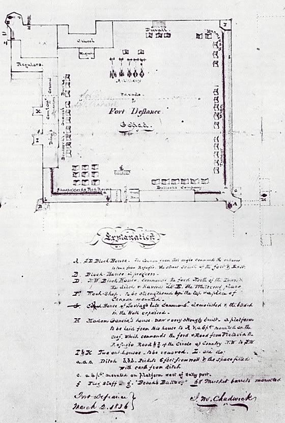 |
|
|
|
Post by Kevin Young on Apr 6, 2012 15:23:32 GMT -5
A scan of the original Chadwick map of Fort Defiance/Presidio La Bahia has now been posted.
|
|
|
|
Post by Allen Wiener on Apr 6, 2012 23:09:59 GMT -5
Thanks guys. Had Fannin remained in this fort, would it have been easier for him to defend and more difficult for the Mexicans to attack, than the Alamo was?
|
|


