Unfortunately, I posted my first description of the Powder House location into an earlier (now relatively inactive) thread started by John Richardson (Hiram) back in March entitled “Where was the Powder House located?”
alamostudies.proboards.com/index.cgi?board=alamohistory&action=display&thread=506. Let me take a moment here to summarize and expand on what I had previously noted regarding the location. I’m including figures (I’m really sorry to you dial-up viewers) to help visualize the location. I will also include a few additional caveats which seem to be missing from the current discussion in this thread. Above is a detail from Hermann Lungkwitz’s ‘Alameda’ painted in 1854 which shows the Watch Tower on the distant horizon.
Last fall, a small group of us including Ric Range, Alfred Rodriguez, Craig Covner, Sam Nesmith, myself, and several others, began compiling background research that would be necessary in order to relocate the Powder House (or "
Garita" as it was known during the Spanish/Mexican periods) and the Watchtower. One thing that we all came to agree with was that the Powder House once lay directly in line with the street then known as the Alameda (now East Commerce St.). Our goal was to narrow the prospective area with the hopes of eventually focusing on a specific site and conducting limited archaeological testing there. We also discussed the possibility of utilizing non-invasive archaeological techniques such as a Ground Penetrating Radar (GPR) and a Magnetometer.
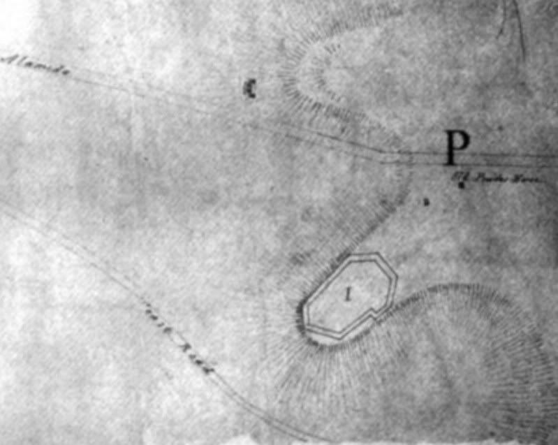
Initially, a series of digital maps was created by overlaying several historic renderings onto modern aerial photographs of the area. Principal among these was an 1863 sketch map showing the environs of San Antonio with planned Confederate defensive fortifications depicted around the city. The bend in the Alameda (now East Commerce) is clearly indicated on this map with two structures sketched immediately southeast of this location. The first, labeled “the Old Powder House” lies directly in line with that portion of the Alameda which extends northwest toward the San Antonio River. The second structure, drawn immediately southwest of the Powder House and not identified by name, is thought to represent the Watchtower.
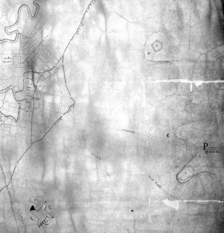
Although city blocks were not yet established east of the Alamo Acequia at the time this map was drawn (see Augustus Koch’s bird’s-eye view of San Antonio, 1873,
www.birdseyeviews.org/zoom.php?city=San%20Antonio&year=1873&extra_info), several features shown on this historic map were helpful in establishing proper scale. Among these were the distinctive bends of the San Antonio River, city streets and blocks located west of the Alamo Acequia, the distinctive bend in the Alameda, and indicators of topographic relief represented by hash marks drawn on the right side of the map in the vicinity of the Powder House Hill. It’s worth noting that these topographic indicators were found to correspond quite well to the AMSL topographic elevation lines 700-720 as depicted on the San Antonio East 7.5 minute USGS Quadrangle map. Unfortunately, there were also inherent errors in scale incorporated into the 1863 Confederate map. While it was possible to resize the historic map so that the landmarks mentioned above fit rather snuggly to corresponding points on the modern aerial, the features did not match exactly at every point.
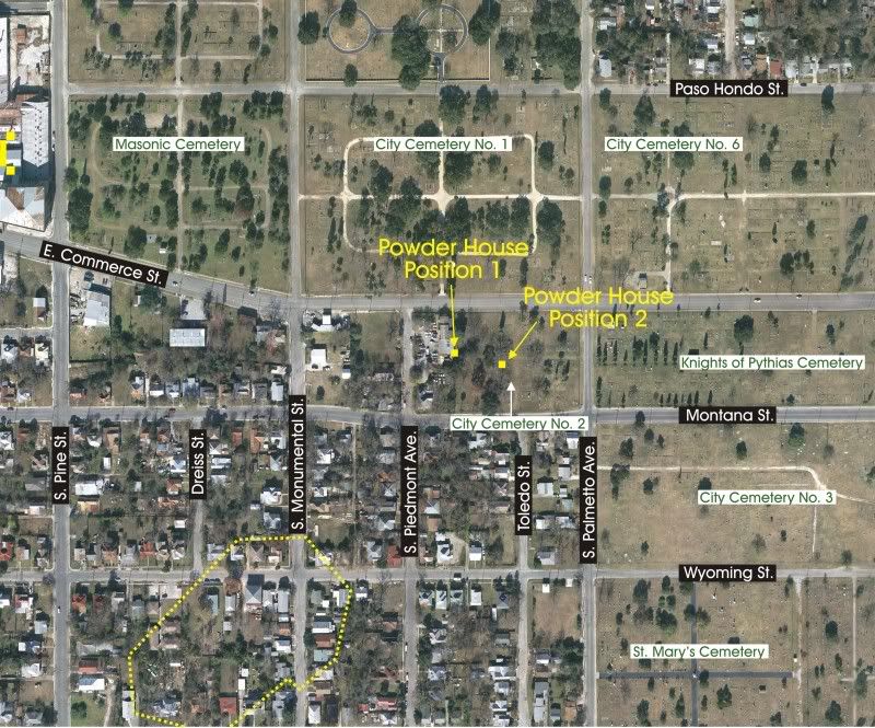
One of these discrepancies can be seen in the vicinity of the Powder House. When the angle point of the Alameda is placed directly over the corresponding bend in modern East Commerce Street, the topographic relief indicators on the 1863 map appear to be slightly misaligned with USGS topographic lines (c. 24 m or 78’). Using this bend in the Alameda as an anchor point, the Powder House is plotted about 15 m (49’) inside the western edge of City Cemetery Number 2 (NCB 1388 Block Lot A2, bounded by E. Commerce St. on the north, S. Palmetto Ave. on the east and Montana St. on the south).
The projected location of the Powder House shifts eastward, toward the center of the cemetery, when an adjustment of the historic map is made in order to improve its relationship with USGS contour lines. This second position falls approximately 16 m (52’) west of the projected curb line of Toledo Street.
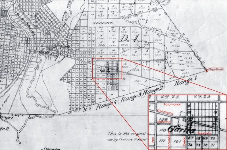
Another map which appears to offer possibilities for the refinement of the Powder House location is the 1852 François Giraud and Jore Gentilz plat of the “Original Town Tract,” originally created to establish proper legal title to lands lying within the city’s boundary (
alamostudies.proboards.com/index.cgi?board=maps&action=display&thread=698). Here, the
Garita is identified by name and is plotted in the center of a larger box which appears to indicate a boundary line or fence. This outer box, oriented with the western alignment of the Alameda, measures about 180 m (590.5’) on each side. In addition, the
Garita is shown to be approximately 694’ beyond the bend in the Alameda.
Unfortunately, a comparison of modern streets with those depicted in the Giraud map reveals numerous discrepancies. Initially, it was thought that many of these differences may be attributable to scaling problems or general sloppiness. Portions of the river and streams can be seen to be slightly stretched and/or misoriented, supporting the ideal of surveyor/draftsman error. However, a more critical review of this map brought out a different question: Why are any streets and blocks depicted in areas where, on the Confederate fortifications map 18 years later, areas are shown to be entirely vacant? Koch’s bird’s-eye view again confirms the absence of any development across this area as late as by 1873. So, it is clear that the Giraud map depicts only planned city development, not actual streets and city blocks present in 1852.
Scaling the Giraud map was accomplished in the same manner as that used with the Confederate fortifications map. The San Antonio River served as the principal western anchor and the Paso Hondo was used as a reference point in the east. The Paso Hondo, a ford of Salado Creek, also served as the easternmost boundary corner of San Antonio’s original town tract. Today, the Paso Hondo would be located adjacent to Aransas Avenue, or approximately where the I-10 bridge spans the Salado.
The next step after establishing proper scale was to ascertain precisely which modern streets are represented on the 1852 map in the vicinity of the
Garita. Because most of these streets run either north/south or east/west and because confusion over street alignment accounted for some disagreement among team members, I wanted to be positive of the map’s proper alignment. To this end, I began by identifying streets and alignments not oriented in cardinal directions and common to both the historic and modern maps. These include E. Commerce St., Hedges St., Bowie St., Bonhan St., Crockett St., Durango Blvd., and Aransas Ave. Thus, it was possible to properly establish the alignments shown on the Giraud map in the vicinity of the
Garita. These are (running north/south) Pine St., Monumental St., Toledo St., and New Braunfels Ave. and (oriented east/west) Paso Hondo St., E. Commerce St., Montana St., and Wyoming St.
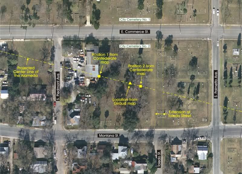
This places the center of the Powder House 24 m west (78’) west of the projected curb line of Toledo Street, again squarely in the western portions of City Cemetery Number 2. This position falls between the two locations established using the Confederate fortifications map and only 26’ from the second of these positions.
A better understanding of the size and orientation of the structures can be gleaned from historic accounts of the Powder House. One of the earlier descriptions of the site was made by French naturalist Jean Louis Berlandier, who visited the Powder House in 1828.
On a hill situated to the east of the Alamo de Béxar there is an abandoned powder magazine called La Garita. General An. Bustamante, intending to quarter troops there, wanted a well dug, but the enterprise was abandoned at a depth of 29 varas (24.5 m., 80.5’) a rock was reached which the workers could never break. Wishing to profit from that circumstance to gain an idea of the formation of the terrain in the environs of Béxar, we went there twice to reconnoiter the materials which had been extracted (from Jean Louis Berlandier’s Journey to Mexico During the Years 1826 to 1834. Volume Two, page 296).
Another vivid description offering a bit more information about the physical appearance of these structures can be found in a diary entry of Harvey Alexander Adams, a participant in the Somerville Expedition of 1842-43.
November 1, 1842 - Today seven of the company with myself went on an exploring expedition; we directed our course from our ca(m)p to the Powder House 1½ miles N. E. (sic) of San Antonio. This building is constructed of materials similar to those in the missions; the walls are about 2 ½ feet thick, plastered outside and in. The inside is marked off with different sorts of objects – on one side is the rough representation of a cannon with two cannoniers in the rear of it, one of them applying the fuse to the touchhole. The building is three stories high with a parapet on the top and a pinnacle at one corner raised a few feet above the parapet; the building is about 16 feet square inside, the walls pierced with port holes, three on a side. The floors are supported by joists and slatted (sic) with a thick coat of concrete to form the thickness of a foot or more. Then adjoining near it, is a one-story building about ten feet square on the inside, which was probably used as a magazine. These buildings are situated on a high eminence and overlook the whole country, and command a fine view of san antonio (sic) in particular (from the H.A. Adams diary /2J112 CAH, Pages 15 and 16 of typescript. Center for American History, UT at Austin).
A third description included here was made by Lieutenant George Hughes of the U.S. Topographical Engineers in 1846.
About one mile east of the Alamo is a strong tower, twenty-one feet square at the base, thirty feet high, sixteen feet square at top, three stories high, with a look-out on top. It is built of stone, the walls three feet thick, with three loop-holes on each side. It is not arched. The entrance is from the east. Within a short distance of it stands another building, eighteen feet square at base. Twelve feet high, and with a groined arch; the walls are three feet thick – the entrance from the west; it was obviously a magazine. The two buildings are defended on the southeast angle by a bastion with two long curtains enclosing the buildings on two sides. The advance works are of earth, and consist of a deep ditch and parapet. Between these works and the building was a well, now particularly closed with rubbish (from Hughes’ report, Memoir Descriptive of the March of a Division of the United States Army under the command of Brigadier General John E. Wool from San Antonio de Bexar to Saltillo in Mexico. Senate Document of the first session of the 31st U.S. Congress, Vol. 10, Document 32).
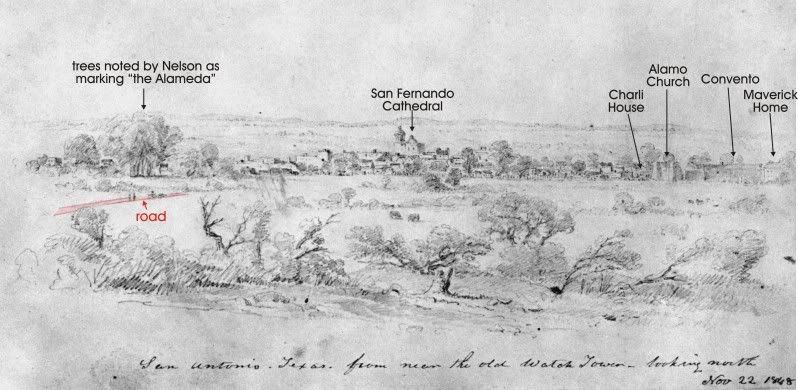
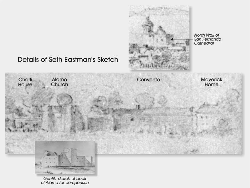
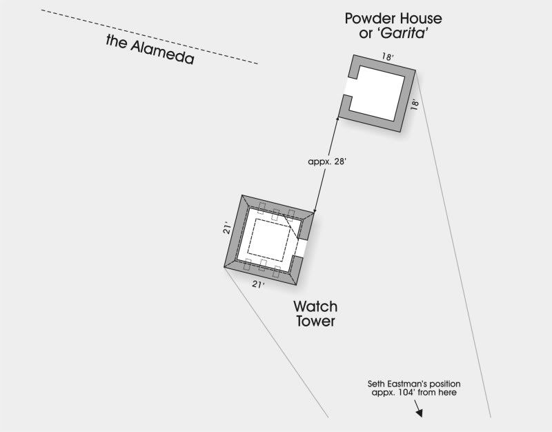
From these three written accounts, it is possible to reconstruct a relatively accurate plan map of the Powder House complex, especially when taken in conjunction with the 1848 sketch by Seth Eastman in 1848.
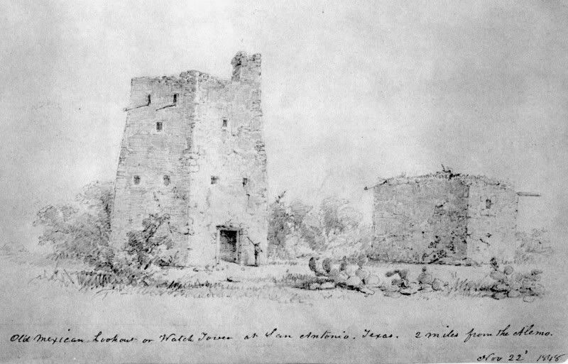
The Powder House was a one story stone structure, about 18’ (5.5 m) square, with an arched doorway facing west-northwest toward the Alameda, a bearing of approximately 256°. The thick walls of the magazine (around 3’ or 0.91 m) extended up around 12’ high. A small loophole was present on the western side of the magazine at approximately nine feet above the outside surface.
The Eastman sketch indicates that the Watchtower was oriented similarly to the Powder House. With a rectangular doorway facing toward the east-southeast, the three-story high stone tower (approximately 30’) would have been 21’ square (6.40 m) at its base with walls approximately 2.5’-3’ thick.
Using the Eastman sketch, it is also possible to tease out a few additional details about the complex not revealed in the accounts above. Accepting the premise that both structures are similarly oriented, a few general principals or perspective can be applied to obtain additional information. To this end, one additional assumption must be made: that the eastern wall of the Watchtower rested along the same line as western wall of the Powder House. While this certainly appears to be the case based upon the Eastman sketch, it is possible that the magazine could have been offset slightly. Unfortunately, the two-dimensional nature of any landscape drawing, regardless of its accuracy, doesn’t allow for the absolute discernment of depth. In other words, it’s possible that the supposed alignment of the two walls is an optical illusion.
However, the following reconstruction accepts that the walls were aligned along the same plane. Initially, measurements of the wall lengths of the two structures were applied to the drawing. Based on these dimensions and taking into account the effect of perspective, it is estimated that the two buildings would have stood approximately 28’ (8.53 m) apart. Measurements taken on the southern and eastern walls of the Watchtower being very similar, it was deduced that Eastman was positioned virtually diagonal to this closest structure. Similarly, measurements were taken of the Powder House walls, resulting in a 66% (south wall) to 34% (east wall) ratio. In other words, Eastman was able to view much more directly the southern wall of the Powder House than he was the east wall. These mathematical ratios were in turn applied to establish the perspective point of the Eastman.
Seth Eastman was viewing toward the north-northwest, approximately 23° west of north, when he made this sketch. He was located some 150’ (45.7 m) from the southeast corner of the Watchtower and approximately 182’ (55.5 m) from the same corner of the Powder House. Verification of this orientation can be found in the Eastman drawing itself. If you look at the extreme left-hand side of the sketch, a single tree can be seen discerned over the crest of the hill. This shows just how close to the topographic break of Powder House Hill these features actually were. Once again, this matches very well with the suggested location inside City Cemetery #2.
In conclusion, we were not able to physically relocate the Powder House complex during our project last fall. Our focus on the cemetery as the primary location virtually ended all hope of probing the ground in search of archaeological evidence. Even our goal of carrying out a non-invasive GPR/magnetometer survey was blocked by City officials. Unfortunately, these methods probably wouldn’t have told us a great deal anyway, since the density of packed graves in this area have likely removed or disturbed most of the old foundations.
We were able to met with adjoining property owners, many of whom who were kind enough to grant us full access to their property. One elderly gentleman who had lived in the neighborhood all of his life even told us that he recalled seeing piles of cut stone just west of South Piedmont Avenue when he was young. Unfortunately, his memory was not sharp enough to give us more than a vague recollection of this childhood memory.