|
|
Post by marklemon on Jun 2, 2009 10:51:33 GMT -5
On a recent trip to San Antonio, I rode with Gary Foreman and his wife Caroline to the ridge east of the Alamo where the old powder house and watch tower were located. The exact site is unknown, but folks like Rick Range and Craig Covner are conducting research into finding it s specific site. Looking over the ground, however, and as Gary pointed out, one thing is clear. It was certainly not to the south of Commerce Street (or the old Gonzales Road) in which location is seems always to be depicted, at least by contemporary artists, myself included. This area (the south) is at least 40 to 50 feet lower in elevation that the north side, which rises to a plateau, before dropping off again to the north. Placing the tower in that location would render it almost useless as an effective post from which to observe the surrounding area.
The likely site is just off Paso Hondo Street, (which itself is off of North Pine Street), in the Masonic Cemetery, to the north of Commerce. This site measures about 1,533 yards, and about 1,330 meters, from the east face of the Alamo church.
|
|
|
|
Post by Don Allen on Jun 2, 2009 12:06:44 GMT -5
Please keep us updated as you gain more knowledge about the powder house site. I've spent more than one occassion driving/walking around that exact area and, due to the cemetery, there is nothing even resembling a physical remnant of the building or even a suspicious change in the soil/ground, etc.
In the years that I've spent tracking down the exact locations of various historical sites, I've learned to never underestimate the layout of longstanding/existing roads. There is almost always a reason why a road is laid out precisely where it is, and where they turn or make a slight jog one way or the other, is usually an indication of a former property line or item of interest.
That having been said, the jog that Commerce St. takes where it crosses S. Monumental is very interesting. Not only is there no apparent reason why it would turn slightly there, but it is almost exactly at the highest elevation in that area.
It does appear that, at one point in time, Commerce St. continued in a straight line, at one point in time, past the S. Monumental intersection, to become Hedges St.
In the mid 1800's a tall structure like the powder house tower would've been something that one would've seen for miles as you approached from the east or southeast and you would've known that that was a marking point for San Antonio. Once you made it to that point, at the top of the hill, San Antonio would've been down towards the river...hidden from view until you reached this point, that I suspect was the location of the powder house.
|
|
|
|
Post by rriddle3 on Jun 2, 2009 15:14:55 GMT -5
|
|
|
|
Post by TRK on Jun 2, 2009 16:23:58 GMT -5
To which I would add, I believe I understand the separate locations for the Powder House that Mark as well as Craig Covner and Bruce Moses are proposing, but a check of Google Earth, which is reputed to have a pretty accurate elevation function, shows the elevation of the Covner and Moses sites as ~ 720'-733', whereas the maximum elevation in the Masonic Cemetery to the north of Commerce Street appears to be ~ 737". (The Moses and Covner sites are in the area bounded by Commerce St. to the north, Montana St. to the south, Piedmont Ave. to the west, and S. Palmetto Ave. to the east.) Unless Google Earth's elevation function is giving wildly incorrect readings in the Masonic Cemetery, how to account for the fairly small variation in elevation GE is showing between the south side of Commerce and the north side? |
|
|
|
Post by marklemon on Jun 2, 2009 17:47:32 GMT -5
To which I would add, I believe I understand the separate locations for the Powder House that Mark as well as Craig Covner and Bruce Moses are proposing, but a check of Google Earth, which is reputed to have a pretty accurate elevation function, shows the elevation of the Covner and Moses sites as ~ 720'-733', whereas the maximum elevation in the Masonic Cemetery to the north of Commerce Street appears to be ~ 737". (The Moses and Covner sites are in the area bounded by Commerce St. to the north, Montana St. to the south, Piedmont Ave. to the west, and S. Palmetto Ave. to the east.) Unless Google Earth's elevation function is giving wildly incorrect readings in the Masonic Cemetery, how to account for the fairly small variation in elevation GE is showing between the south side of Commerce and the north side? Tom, This may be true, as we did not examine the Covner/Moses site. Actually, I did not know that they were proposing that particular site as a possibility. However, if one stands at the Paso Hondo (Masonic cemetery) site, and looks directly south, the ground drops off very dramatically as one looks towards Commerce Street. Alamo docent John Richardson, a very knowledgeable Alamo student, believes it is in the area I proposed, but, again, I have not examined the Covner/Moses site, which is farther east, and south, and may in fact be higher than the low-lying area I observed. I'll certainly take a look at the other site when I return. Mark |
|
|
|
Post by cantador4u on Jun 3, 2009 22:08:16 GMT -5
I'm thinking that though the location of the Garita/Powder House hasn't changed, maybe the maps have. To be more specific, on page 2 of my copy of the Nelson book is a map drawn by Rullman in 1912 intending to show San Antonio of 1836.
It shows the Alameda heading out of town. Eventually it makes a fork. The upper fork is identified as Camino de Paso Hondo, and the lower fork as Camino de Paso Torato. Unfortunately it doesn't continue out far enough to show the location of the Powder House, but it would seem that it would be on the Caminio de Paso Hondo, or Paso Hondo Street of today, not Commerce St.
Any ideas of why this one map is labeled this way? Does it represent the Paso Hondo St of today?
|
|
|
|
Post by marklemon on Jun 3, 2009 22:47:37 GMT -5
Looking at the map of San Antonio in the area of Commerce, and Paso Hondo, it is clear that the current Paso Hondo is what's left of the original, which once branched off of Commerce, but now has been segmented and is apart from it. Another interesting and intriguing thing is that Commerce, just when it makes its bend to the east, lines up exactly with Hedges Street a few blocks away, which is at the precise same angle as Commerce, a few blocks back to the west.
I wouldn't be in the least bit surprised if Commerce has changed its course, and once connected with the present day "Hedges" Street.
|
|
|
|
Post by cantador4u on Jun 4, 2009 11:02:17 GMT -5
Looking at the various maps of San Antonio I've found across the web, I have a 1904 topo map which shows Paso Hondo going through the hills and an indication that it continues beyond.
Commerce street makes its familiar bend to the east and comes to an end at what looks like a residential area.
It would appear that Commerce street could have at some point connected with Hedges street but I have an 1889 map that does not show a connection. But IF IT HAD, Hedges St also comes to an end with no indication that it continued beyond as Paso Hondo does.
So help me interpret this.
A. The Powder House/Garita was on the hills overlooking Bejar.
B. It was on the road that led to Gonzalez
C. A 1904 USGA topo map shows that Paso Hondo extends beyond the boundry of San Antonio.
D. The same map shows that Commerce St (as well as Hedges St if they ever were once connected) both come to an end with NO indication of extending any further as Paso Hondo has.
Conclusion (?): It seems to me that the Powder House must have been on Paso Hondo not on Commerce St.
But I have a problem with my own conclusion. looking at the same 1904 topo map, it seems to me that the location of Commerce St makes more sense in terms of path/road building and travel, having less of an incline from the top of the hill down to the more level area around San Antonio than does Paso Hondo.
"...Two roads diverged in a wood
And I took the one less traveled by
And that has made all the difference"
Robert Frost
|
|
|
|
Post by Don Allen on Jun 4, 2009 13:50:55 GMT -5
Here is an image pulled from an 1889 map of San Antonio. 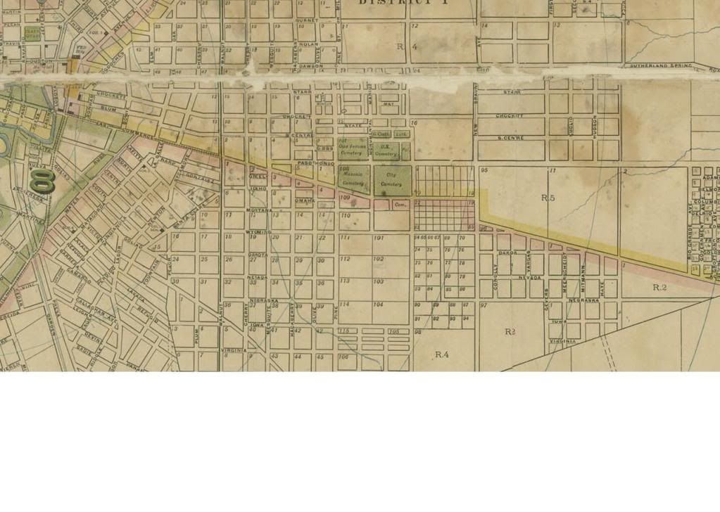 |
|
|
|
Post by Don Allen on Jun 4, 2009 14:14:28 GMT -5
I found a 1909 map of San Antonio that lists what is now Hedges St. as being E. Commerce, and it continues for quite a distance to the edge of the map. On this map, what is now Commerce is listed as N. Commerce.
I also found a 1920 Automobile map that does, in fact, show what is now Hedges St. as being a continuation of Commerce and also notes that it is the route to Houston via Cuero and Hempstead.
So...this seems to pretty solidly verify that Commerce continued in a straight line past the Monumental St. intersection until the modern cemeteries were placed on top of it.
That leaves Paso Hondo St. as a curious thing. The name means "deep pass" in spanish. With a spanish name like this, appearing on maps in the 1880's, it would seem to be a road that had been around for some time. Notice that all the streets, laid out in nice squares around Paso Hondo, have english names. At present it's based on little more than my intuition, but I suspect that Paso Hondo could date to the very early days of San Antonio and might be one of the roads that led up to the powder house. Could Paso Hondo be the road that is depicted just north of the powder house in so many drawings, and if so, could the area in bewteen the "V" made by the splitting of Paso Hondo and Commerce, be the logical spot where the powder house stood?
It would be nice, if one of the Texas universities has access to ground penetrating radar, to scan the high potential areas.
|
|
|
|
Post by Don Allen on Jun 4, 2009 15:17:28 GMT -5
Shame on me for not looking in library until now, in relation to the roads to the east of San Antonio.
On page 2 of George Nelson's, "The Alamo, an Illustrated History", is a map drawn by John D. Rullman based on old city maps and accounts from private citizens on the roads in 1836.
As I suspected, Paso Hondo (Camina de Paso Hondo or...the road/highway of the deep pass)is present. It appears that the fork in the road that I refer to in my previous post is present as well, with the south branch of the fork being Camina de Paso Toritto sp?)
Again...it seems logical that this fork might've gone around the powder house...but that is obviously just a guess.
|
|
|
|
Post by marklemon on Jun 4, 2009 18:05:12 GMT -5
I'm going to retract my earlier statement concerning a likely location of the powder house, as a closer inspection of the Civil War-era map clearly shows it to be just where Covner and Moses are saying it was.....a spot bounded by Commerce, Montana, Piedmont, and Palmetto. And, according to the map, it was nearer to the interior angle formed by Palmetto and Montana.
|
|
|
|
Post by Don Allen on Jun 4, 2009 19:12:37 GMT -5
I'm going to retract my earlier statement concerning a likely location of the powder house, as a closer inspection of the Civil War-era map clearly shows it to be just where Covner and Moses are saying it was.....a spot bounded by Commerce, Montana, Piedmont, and Palmetto. And, according to the map, it was nearer to the interior angle formed by Palmetto and Montana. Mark...that corner appears to have an old pier and beam, frame house sitting on it, which is probably a good thing if there is any hope of ever finding some sort of an buried remnant of the building. One would think that if the powderhouse is in the cemetery, then the multiple graves would've pretty much destroyed anything worth examining. |
|
|
|
Post by marklemon on Jun 13, 2009 19:36:09 GMT -5
In conducting research on the powder house and garita, I observed an error in Nelson's book , second revised edition, pages 44 and 45. At the top of the pages Nelson places two sketches, both drawn on November 22, 1848 by Eastman, side by side, and says that "this forms a panoramic view from the hilltop towards the town of San Antonio de Bexar."
Based on two separate sources, one of which is Eastman's drawing itself (the other is on pg 82, a map of San Antonio during the Civil War), I have determined that this is incorrect. The drawings do not constitute a panorama, but rather are drawn from two different directions.
Eastman was situated directly south of the two buildings. The Gonzales Road was behind the two buildings in the near distance. He drew the buildings as he looked north towards them, and then simply turned to his left, and drew the vista towards San Antonio. By the time he had completed the first sketch (powder house, etc), perhaps 30 to 45 minutes had passed, allowing the sun to move a bit more towards the south and west. He then drew the vista, in which the sun is slightly more from due south.
As Nelson places them, the light source is not consistent when the two are placed side by side. Also, in the pg 82 map, the powder house is marked as being closest to the road (Gonzales Road) a situation which would be inconsistent with Nelson's "panoramic" placement.
An esoteric detail, I know, but one which may mean something to someone....
Mark
|
|
|
|
Post by Rich Curilla on Aug 18, 2009 23:50:55 GMT -5
Mark, I do not get the error in George's caption (I am looking at his first edition -- other one's at the office -- so they may be different). His comment is solely about the drawing of the town. I see nothing in the comment or format that applies the (rather awkward) statement to both pictures. The only error I see is the one I've always seen, which is Eastman's own note on the drawing saying that he is looking north. He ain't. He's looking due west.
But this could be explained by your rather groundbreaking interpretation of his other drawing. I (we all?) have always just assumed that the artist was sitting with his back to the Alamo, looking east or east-south-east. Still possible, I suppose, but I hear your point about the light and Eastman's time frame. If, as you propose, he is looking north at the structures (thus aligning them with the Civil War map), then he simply confused his labeling and said he was looking north in the other drawing rather than this one.
This Watch Tower / Powder House thing has been a fascination of mine forever, and I think we will soon nail its exact location. I believe a lot can be based on the *lay of the land.*
My long-held belief has been that it was placed on the highest prominence on Powder House Hill. Otherwise, what's the point? You want to be able to see in all directions. And I still feel this way. But the plan might have been to simply see east and west along the main road, and the evidence supports this.
"Paso Hondo" must have been what they called a low spot between two knolls on the ridge. Thus "Camino de Paso Hondo." The word does indeed mean shallow or low.
Bandera Road in San Antonio (Rt. 16 to the N.W.) isn't just named that because it goes to Bandera. Bowie's report (or his brother's) on the Battle of Calf Creek begins by stating that his expedition left Bexar and travelled up "Camino de la Bandera" (Highway of the Flag, literally) long before the town of Bandera existed. Old maps have the road traveling through "Bandera Pass," most likely carried forward from the Spanish "Paso de la Bandera."
My point is that 18th. Century Bejarenos named some roads after the passes they traveled to get them out of the river valley.
Thus, Camino de Paso Hondo was named thusly because it left Bejar and headed for the low pass to the east.
Now. Let's turn to iconography. We have, to my knowledge, six contemporary drawings/paintings which show the watch tower from the distance. Two Gentilz, two Chamberlain, one Eastman and one Lungkwitz. Of these, three show the tower on the very top of a knoll. Herman Lungkwitz' painting "The Alameda," Theodore Gentilz' "Corrida de la Sandia" (Watermellon Race) and a not-very-reliable Sam Chamberlain painting from Main Plaza. There is another Chamberlain that I have in The Spanish West at the office and can't check. It shows, not one, but two watch towers (leading me to wonder if there might have been another west of Bexar). Anyway, I can't recall if these are on prominences or not. But two clearly show the watch tower on the ridge next to a higher knoll. These are Eastmen's "North Side of Alamo Church" and Gentilz' more accurate and precise sketch for "Watermellon Race" with artistic license. And, if accurate, the Civil War map is conclusive evidence that the tower was in the notch and not on the hill.
So my theory is that modern day Commerce St. dog-legged left and followed the current Paso Hondo St. in 1836 and that the tower was just off to the right, thus placing it north of the present Commerce St. This would be in the general area bordered by pine on the west and Palmetto on the east. Best bet is east of Monumental in that cemetery. Isn't that where the defenders remains are supposed to be buried according to that article in the early 20th. Century?
Distances?
1,225 yards from Alamo apse battery to the conjectured dogleg where Paso Hondo starts. (vs. 2,024 to current Commerce St. dogleg).
Paso Hondo (thus the Gonzales Road) crests Powder House Hill at 2,237 yards, and actually travels the crest of a subtle perpendicular ridge running west to east. This really sells it to me as the main road. At the crest, the road is 738 feet above sea level. The apse battery is 657.
There is a slight knoll on Powder House Ridge 400 yards north of Paso Hondo. This is 742 feet above sea level.
Gentilz' drawing before his Watermellon painting depicts the tower on the ridge with a knoll just to the right of it, fitting this scenario exactly.
Therefore, I conclude that the watch tower and powder were on Powder House Ridge between 2,000 and 2,250 yards from the Alamo apse battery. Looking from the Alamo, it would appear to be just to the right of the Camino de Paso Hondo with a subtle knoll just to the left of the road.
Unfortunately, I think the Civil War map foreshortens the distances -- definitely places the hill too close to the Alamo. With this inaccuracy, the structures could have been anywhere east of the Paso Hondo dogleg, placing their site under any of the warehouses and other structures anywhere between Mesquite St. and Pine St.
If you use the corner of Pine and Paso Hondo as a place to start, this is exactly 1,752 yards from the Alamo's apse battery. Mark and I differ on distance here. My source is a measuring device on Google Earth 3-D, and, using the cemetery range from Pine to Palmetto, then the distance is between 1,752 yards to 2,274 yards from the Alamo's apse guns.
These are all still "what ifs," but I think we're very close.
|
|


