|
|
Post by bmoses on Dec 27, 2007 19:22:28 GMT -5
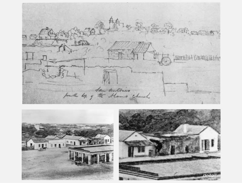
Thanks for the clarification Mark - I think that makes good sense. I've rescaned the image to include the southern Charli house doorway.
|
|
|
|
Post by Jake on Jan 4, 2008 14:55:03 GMT -5
Bruce:
You did good -- pretty much caught the details properly.
There are several descriptions of this property of use to us -- the earliest was in 1786, when the property was granted to Charli, including both the room in the southwest corner of the Valero compound and the house just outside the walls to the south. It was resurveyed in 1793, and then again by Francois Giraud in 1849, with a new description by him in 1850. With all that, it's still somewhat difficult to figure out what the plan of the place is, and far too much space would be required to run through it here.
I think it was Craig who pointed out to me that Bollaert was apparently showing the Charli house south of the Losoya house in his rough drawing, and once you've had that pointed out, you can easily recognize the dark gray structue from the photograph in Bollaert's drawing. So the other building, the well-drawn one to the north, is the Losoya house in the form it was rebuilt after the battle. That second section of the Losoya house on its north end was a jacal component of vertical posts (also shown on the J.E.B. map of the 1840s, Nelson, 2nd ed., p. 66), and Anne Fox found the holes for these posts dug into the adobe bricks of the earlier Indian house when she dug the "Alamo Theater," the space just north of the Radio Shack -- this was the other half of the one building on the west side that hadn't had a cellar dug beneath it.
|
|
|
|
Post by TRK on Jan 25, 2008 16:26:16 GMT -5
There appears to be some confusion here about the Charli house and the Losoya house which were in fact two seperate structures. The Losoya house was rebuilt over the ruins of Charli's workshop (adobe) which was the western (north/south running) structure in the southwest corner of the compound. The Charli house (stone) was located outside (south) of the compound. There was some confusion, alright, and it was in my first post above. Thanks to Jake, I now have a copy of city surveyor Francois Giraud's plat of the lots around the southeast corner of the Alamo compound, and the survey I summarized in the post above was actually that for what is commonly referred to the Juan Losoya lot and house, the house being at and within the southwestern corner of the compound. The plat also shows the Concepcion Charli house, outside and to the south of the SW corner of the compound, and indicicates that the west side of the Charli House was in direct line with the western wall of the Alamo compound. Described as "Stone House," it measured 9 1/2 varas (26 feet) east to west and 18 1/8 varas (50 feet) north to south. There was an interval of 14 3/4 varas (40 1/2 feet) from the north side of the Charli house to the south face of the old south wall of the Alamo compound (or, on the plat, "Muralla of the Alamo"). My apologies for that erroneous first post. |
|
|
|
Post by marklemon on Jan 26, 2008 0:31:18 GMT -5
The measurements of 26 feet east to west, and 50 feet north to south, indicates that the house, once one of the mission's three-"room" Indian houses, consisted of the northern two of its original three rooms, (the southernmost room was missing) and these two rooms had the old original arches still attached, but most likely filled in (see the photo in Nelson's). The house 's dimensions work out this way (assuming a wall thickness of two feet): Interior of rooms 12 feet east to west, and a porch interior of 8 feet east to west. Also, each room would have been 22 feet north to south. These are the measurements (thanks Jake) that I used on building the Charli house in my model used for my book.
|
|
|
|
Post by Rich Curilla on Jan 27, 2008 1:47:32 GMT -5
You see, I am already being educated by your findings. Remember the earlier questions (and false assumptions) I had about this building. They were locked in for years. Well, now it is clear in my head. This model and book will truly chronicle all that Jake Ivey, Craig Covner, Tom Hester, Bruce, and Mark himself have discovered. Bravo!
|
|
|
|
Post by pff on Jun 12, 2009 6:39:01 GMT -5
In the drawing scanned to this website-what is the structure in the foreground-part of the main gate/short barracks?
|
|
|
|
Post by marklemon on Jun 12, 2009 10:39:29 GMT -5
The artist was standing atop the north transept, or perhaps atop the north nave wall. The structure in the foreground is the inside (east-facing) wall of the facade of the church. The opening is the choir loft window.
|
|
boba
Full Member
  
Posts: 36
|
Post by boba on Aug 15, 2011 10:34:28 GMT -5
Looking at Mr.Nelson's book on page 73,the Maverick home ,a rundown house appears in the background on the left side of the photo.Could this be part of one of the Castenada houses?It seems to have a filled in arch on the right side of the structure.If not,could Maverick have built his house on an existing portion of the single room northernmost structure shown still standing in the 1840's?
|
|
|
|
Post by Mike Harris on Oct 2, 2013 15:42:15 GMT -5
By 1836, the area of the Charli workshop had been converted into a gun position. It was noted by a Mexican officer after the battle that a fortification ditch had been built up "...to reinforce the southwest corner because here the main wall was too low". Much of the confusion about the location and appearance of the Charli home and workshop after the battle are the result of General Andrade's thorough razing of the compound following the defeat of Santa Anna at San Jacinto. As Dr. J. H. Barnard reported "...the Alamo was completely dismantled, all single walls were leveled, the fosse filled up, and the pickets torn up and burnt."  Hello gang, I've been going through some old threads while doing some west wall resarch for my '36 model. I've been searching for this specific "reference" by a Mexican officer after the battle who said they had to build/construct a fortification ditch due to the low height of the SW corner. Does anyone know who the Mexican officer was that made this claim and where I might be able to read his entire description? Thanks for you help! Mike |
|
|
|
Post by Rich Curilla on Oct 4, 2013 11:23:07 GMT -5
   To provide a bit more visual orientation and illustrate (as best I could with my virtual model) how we have viewed the Charli-Losoya workshop and later the Cos/Neill defenses in the southwest corner of the Alamo, I'm including these three shots. 1) My preliminary construction of the mission period building as interpreted from mission inventories and the archaeological digs. This model is accurate to measurements gleaned by Brad Ponder from the above-ground replicated S.W. corner walls on Alamo Plaza. The replicated walls were built directly over all foundations discovered in the late 70's and early 80's. 2 and 3) The results of my deconstruction of the mission Indian building represented in #1 to the condition it supposedly was in during the sieges of the Alamo as the result of Gen. Cos' and Col. Neill's fortifications of 1835-36. The southernmost room was converted into the cannon platform that ultimately supported the 18-pounder, the northern room became a storage/repair area and command post for the artillery. This suggests the possibility (as per Mark Lemon's model and book) that the blacksmith shop was located in the area as well. (Sorry for the latter-day forge. Trying to solve that.) Rick Range is about to introduce new information on this portion of the Alamo fortifications from research he has been doing with Mike and Craig Covner, so stay tuned. Mike's super-detailed scale model will be at the March Symposium and will represent their conclusions. |
|
|
|
Post by Rich Curilla on Oct 4, 2013 14:51:58 GMT -5
  Here is the Charli home which was just south of the southwest corner of the fort. It is the darker stone building in Mike's lower-right photo. My model represents its probable 1836 condition when Col. Morales used it as a stepping-stone in his attack on the morning of March 6. |
|
|
|
Post by edward on Nov 8, 2013 22:24:46 GMT -5
The Southern most room of the SW corner of the replicated walls.  |
|
|
|
Post by Rich Curilla on Nov 9, 2013 5:31:23 GMT -5
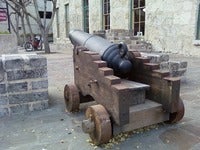
The Southern most room of the SW corner of the replicated walls. View AttachmentYep. You would be standing right under the 18-pounder. Here's Gary Zaboly's great drawing of the 18-pounder in position over that room.  This is Michael Corenblith's 18-pounder from John Lee Hancock's The Alamo during the 175th. Anniversary of the battle.  And Michael's 12-pound gunade. Both guns are exact replicas of the original tubes in the Alamo courtyard.  |
|
|
|
Post by Rich Curilla on Nov 9, 2013 5:40:54 GMT -5
 A less-than-18-pounder on the Charli room in my virtual model. |
|
|
|
Post by edward on Nov 12, 2013 19:48:34 GMT -5
A less-than-18-pounder on the Charli room in my virtual model. Nice virtual models. |
|