
Post by bmoses on Sept 11, 2009 0:10:26 GMT -5
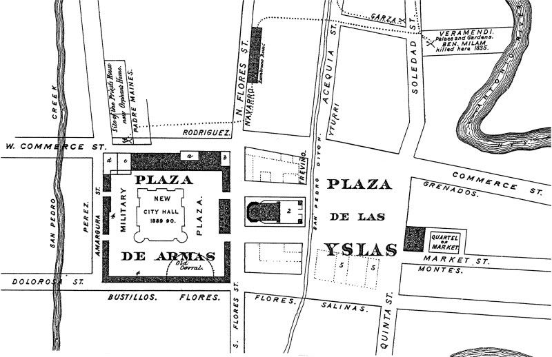
Map Legend
1. The old Church of San Fernando.
2. Churchyard Burying Ground, now covered by the Cathedral of 1868-72.
3. The Presidio Garrison Barracks, long since removed
4. The old Plaza de Armas Dwellings and Ramparts. All 3 and 4 were claimed by the city as city property and in most cases the city substantiated these claims, and, acquiring it, cleared the old buildings away. The lot marked b was the last private property to disappear – 1889. In the ‘40s and 50s a man named Goodman gave much trouble before he was finally ousted by law by the city. Plats of most of these city properties, and the name of claimants, may be found in Book 1, City Engineer’s Records. The City Hall of 1850-90, with City Jail, occupied N.W. corner, c.d.
5. Properties of N. Lewis, Callaghan, Groesbeeck (sic), et al., on Main Plaza, claimed and cleared by the city similarly to those on Military Plaza (See note 4).
6. The isolated Spanish family names on the plan are those of some of the original property holders.
7. The faintly dotted lines to and from the Veramendi and Garza Houses are the approximate router to Zambrano Row and to the Priest House taken by the besieging companies under Milam and F.W. Johnston in 1835. The capitulation of Cos to Burleson followed in 1835.
1890 - William Corner included this reconstruction of the 1835 Seige of Béxar in his book “San Antonio de Bexar: A Guide and History”. Corner included information from city plats, records, historic documents, and firsthand accounts to recreate the town and events as they were in December, 1835. Corner's self-published book was one of the first comprehensive guidebooks to the city. Published by Bainbridge & Corner, San Antonio.