|
|
Post by Rich Curilla on May 26, 2010 17:50:47 GMT -5
The video is amazing! Great to finally see what I had in my mind's eye while standing in those present-day locations. -- Now I want to see the whole town! Me too -- and I'll even supply the mashed potatoes. ( ;D) |
|
|
|
Post by Paul Sylvain on May 26, 2010 19:42:32 GMT -5
This is so well done. Nicely done.
Paul
|
|
|
|
Post by Rich Curilla on May 13, 2014 16:50:17 GMT -5
The video is amazing! Great to finally see what I had in my mind's eye while standing in those present-day locations. -- Now I want to see the whole town! Voile!    |
|
|
|
Post by edward on May 13, 2014 18:48:14 GMT -5
There is so much on this site that I had not seen this outstanding video. Excellent work James!
Rich, your model of the Town looks great!
|
|
|
|
Post by jrboddie on May 13, 2014 19:19:06 GMT -5
I got sidetracked by programming projects so I am way behind you guys. Anyway, I could not help myself from posting this work-in-progress shot approximating Nelson's bird's eye view. The model is in Blender.  |
|
|
|
Post by Rich Curilla on May 19, 2014 15:35:20 GMT -5
 Hahaha! Funny you should mention. I just did an "after George Nelson" angle myself two days ago. Seems like we're both pretty much on the money.  Unfortunately, due to the high MB's of my model, I've had to keep the Alamo/Plaza de Valero details on a separate model that can be combined with this one when I am no longer saddled with a 15th. century computer that can't navigate it. Love your depiction of the labores. |
|
|
|
Post by Rich Curilla on May 19, 2014 15:52:32 GMT -5
Here's a view of the other model, which, as I said, can be copy-pasted into the main 3x3 mile Bexar model when the time comes. Jim, are you able to do land contours in your program? Looks like you might have some of George's higher ground east of the Pajalache.  |
|
|
|
Post by Rich Curilla on May 19, 2014 16:17:04 GMT -5
My goal has been to be as super-detailed as possible in order to create as clear an image as possible of the 1835-36 reality of both the Alamo (here with the new theory of its west wall) and the Spanish-colonial town.  I have a tendency to enhance the reality of it all with importable models used as "set decoration." After all, I was introduced to this program by an Academy Award nominated Hollywood production designer. lol.  While I have Powder House Hill on its original footprint with the structures the correct distance away, in the correct direction and at the right elevation, I still lack the more gradual slope of the San Antonio River valley. This is why I ask about your program and possible topography.  |
|
|
|
Post by jrboddie on May 19, 2014 16:59:56 GMT -5
Rich, very nice. You have a lot of detail there.
For the hills to the east, I took data from the USGS map and converted it to a gray scale height map. I edited out man-made features like the highway overpasses and buildings that appeared as noise. This map was used to displace the ground mesh. The modeling program smooths out the surface. I ended up sculpting some of the elevations around the river, compound and the Pajalache by hand. That has taken a lot of my time.
The labores , of course, are from the Rullman map and are represented by 4 different textures that I used to apply over the ground. The resolution of these ground textures are really too low to be used for anything except far away shots like the bird's eye view.
|
|
|
|
Post by Rich Curilla on May 19, 2014 18:25:16 GMT -5
Rich, very nice. You have a lot of detail there. For the hills to the east, I took data from the USGS map and converted it to a gray scale height map. I edited out man-made features like the highway overpasses and buildings that appeared as noise. This map was used to displace the ground mesh. The modeling program smooths out the surface. I ended up sculpting some of the elevations around the river, compound and the Pajalache by hand. That has taken a lot of my time. The labores , of course, are from the Rullman map and are represented by 4 different textures that I used to apply over the ground. The resolution of these ground textures are really too low to be used for anything except far away shots like the bird's eye view. So you can't actually get in there and pick the maize. Dang! lol. Well, so each approach has its specific benefits and potential goals. |
|
|
|
Post by jrboddie on May 19, 2014 19:19:51 GMT -5
Yeah, I hesitate to post more here until my model is further along. You can follow my progress and test renders on my blog Alamo 2.0. I try to post an update every couple of weeks. My plan to manage complexity is to define a few scenes in which near camera objects will be rendered in fine detail and background objects in lower res. My current task is to add trees and bushes to the landscape. |
|
|
|
Post by Rich Curilla on May 20, 2014 15:56:01 GMT -5
You are very disciplined. I want it all. LOL.
|
|
|
|
Post by edward on Sept 3, 2014 17:20:09 GMT -5
Screenshot: Working on the SW corner of the Alamo wall. Modeled my own cannon without any dims. Does it look to large? I need to make some textures also.

|
|
|
|
Post by Rich Curilla on Sept 3, 2014 18:19:39 GMT -5
Looks about right to me. Good job.
Is the ramp long enough? Remember, the height of the platform determines the length of the ramp. The regulation length in military field-fortification manuals of the day was 6 feet of length for each foot of elevation. If your platform is 12 feet off the ground, then the ramp is 72 feet long. Of course, as Gary Zaboly has pointed out, it could be less than regulation if limited space necessitated, as in the church, but other than that, probably not. The ramp in my model is shorter than on my first version because I have embraced Rick Range, Mike Harris and Craig Covner's conclusion (based on retranslation of mission inventories and the Trevino deed record) that this portion of the west wall was only 7 feet high. This meant a platform only slightly more than four feet off the ground and a ramp length of less than thirty feet. However, Jake Ivey holds with the interpretation you have shown above.
|
|
|
|
Post by edward on Sept 4, 2014 10:37:42 GMT -5
From Rich Virtual Model: 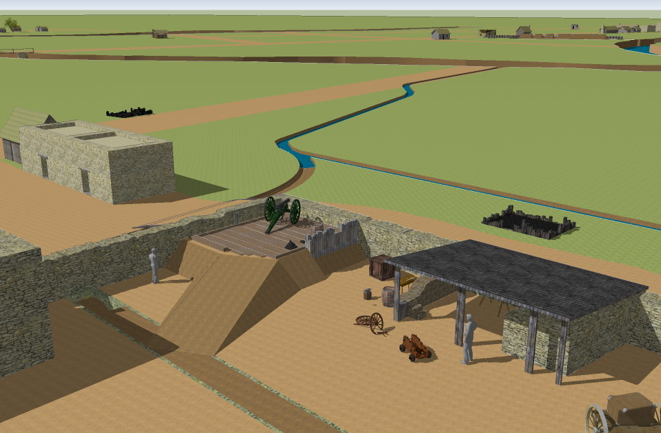

|
|


 Unfortunately, due to the high MB's of my model, I've had to keep the Alamo/Plaza de Valero details on a separate model that can be combined with this one when I am no longer saddled with a 15th. century computer that can't navigate it. Love your depiction of the labores.


