|
|
Post by jrboddie on Jan 5, 2009 20:22:02 GMT -5
I've been studying the Labastida Map and trying to enhance the markings of the acequias. 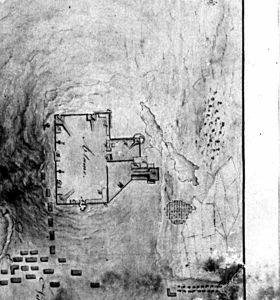 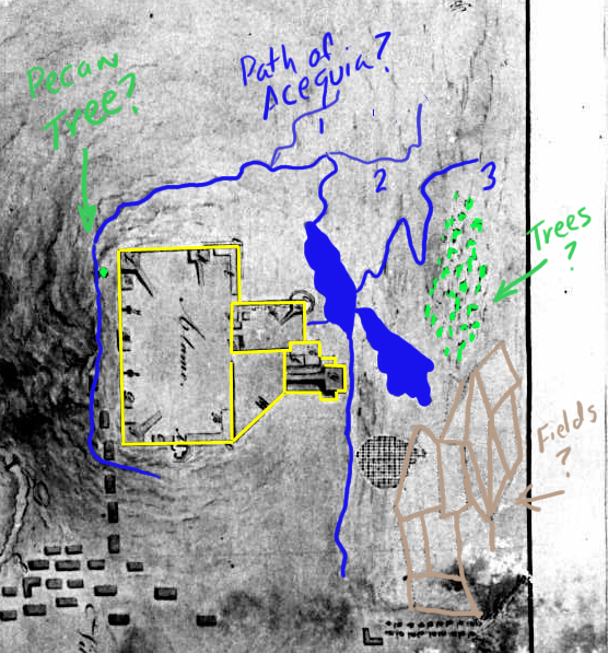 It is very difficult to make out the northern most paths of the acequia. Any thoughts? Also the network of lines to the southeast of the Alamo. Are these fields? Finally, are the clumps of dots representative of trees? I note there is a big dot at the location of the pecan tree (I think). |
|
|
|
Post by marklemon on Jan 5, 2009 21:39:14 GMT -5
Jim, I think that we are coming closer to a more precise understanding of the LaBastida map, and can, if we study the clues it gives us carefully, come to some reasoned conclusions about it. Although it is dated March of 1836, we don't yet know exactly when in March it was made (before, during, or after the siege). Amazing how such a simple omission can cause so much grief for so many, and for so many years..... Anyway, for a number of reasons, I get the feeling from the map that he drew it from on-site, probably from either the north or west, before the battle, while being supplied with "interior detail" data from Cos' officers, or even Cos himself. The reasons are these: 1) The fact that Labastida shows pretty consistently, only those defensive features built by the Mexicans late in 1835, and virtually none of the features we think were put there by the Texians, strongly indicates that the map was created before Labastida had an opportunity to actually go inside the fort, and see what features had been added. Note that the interior two-gun battery inside the main gate, probably made by Jameson, is not shown in LaBastida's map, but IS shown in Sanchez-Navarro's map, which was drawn AFTER SN had been able to explore the fort's interior. Also, the well dug by the Texians DURING the siege, is not shown by LaBastida, bit IS shown by SN, who, as previously noted, went inside. 2) The interesting irregularities in the course of the acequia indicate to me that LaBastida was viewing the Alamo and environs from a distance. From four or five hundred yards, the actual course of the acequia would be indistinct at best. He may have made his way around to the north/northeast, in order to view the rear, or eastern fronts of the mission, (and get a better view of the flooded areas, but either he didn't go around to the south, from which vantage point he could have seen the abatis, or he did go there, and inadvertently left it out. 3) According to Jake Ivey, the lunette in Labastida's plan is a "barbette" position, meaning, the guns there fired OVER the top of the fairly low parapet. But in Sanchez-Navarro, the lunette is quite tall, with embrasures for the guns, and an inner palisade. These features were probably added by Jameson. So, for these and other very esoteric reasons, I feel pretty strongly that the map was made by Labastida before the battle. The fact that the acequias are weakly and irregularly shown indicate to me that he could not get quite close enough to draw them more accurately. To be sure, they should be straighter. I do feel however, that he got the flooded areas more or less accurately, because we know they were there from other sources, and especially the Lee, and Benton paintings. (Click on the link below, then click on the small thumbnail of the Alamo church to the left.) www.cartermuseum.org/books/encountering/art/jb2.htmThis discussion is more important than any of us can realize at this point. I really think that we are finally getting somewhere in the effort to clear up the path of the eastern column under Romero. Mark |
|
|
|
Post by jrboddie on Jan 6, 2009 9:25:43 GMT -5
|
|
|
|
Post by elcolorado on Jan 6, 2009 9:59:23 GMT -5
Well, this is a pleasant find...a terrific view!! Now, if we can just figure out where Romero was when, according to DLP, the guns from the church ripped into his column.
Maybe it's time to consider the possibility that DLP was mistaken about the guns of fortin de Cos. Because of the difficult angle, maybe the church battery never had a clear opportunity to fire on Romero. Could it have been the lone gun in the northern courtyard that was responsible for all the damage?
Glenn
|
|
|
|
Post by stuart on Jan 6, 2009 10:09:02 GMT -5
Interesting and something to be read and inwardly digested at greater length - in the meantime however I have to point out that according to this overlay the history shop site was underwater. Its not impossible that Romero's men were caught while wading through the water, but I'd tend to think that an adjustment of the extent of the flooding might be in order
|
|
|
|
Post by stuart on Jan 6, 2009 10:12:22 GMT -5
Just by the by, Mark has commented before about how excavation would settle the question of the original church location. It strikes me that relatively simple core sampling of the DRT area outside the Alamo ought to find evidence (silt) of the extents of the innundation
|
|
|
|
Post by jrboddie on Jan 6, 2009 10:43:51 GMT -5
If the acequia that exists on the Alamo grounds today runs the same path as in 1836, then the overlay of the ditch and pond (north of the church) appears to be tad too far west. The acequia today takes a little jog around the east side of the museum/giftshop.
|
|
|
|
Post by marklemon on Jan 6, 2009 11:31:12 GMT -5
Interesting and something to be read and inwardly digested at greater length - in the meantime however I have to point out that according to this overlay the history shop site was underwater. Its not impossible that Romero's men were caught while wading through the water, but I'd tend to think that an adjustment of the extent of the flooding might be in order Yes, That is what I was talking about when I said that, after careful study, I had realized that , because of LaBastida's severe foreshortening of the north-south axis of the compound, that the position of the ponds/flooded areas, would accordingly change in relation to the eastern wall of the corrected Alamo. When corrected, the northern end of the flooded area is almost on line with the northern end of the cattle pen, only of course 120 or so feet farther to the east. This correction places the History Shop on dry ground with room to spare. I can see that I'll have to get my new map online somehow to help in the discussion. Can anyone PM me, or otherwise advise me on the photo-posting procedure for this site? Mark |
|
|
|
Post by jrboddie on Jan 6, 2009 12:03:14 GMT -5
I was thinking about this North-South distortion theory and have some doubt. While Labastida got the length wrong, wouldn't he have been right about the pond reaching as far north as the North Wall? Maybe there was a perspective problem from where he made the drawing. If only he could have seen the gift shop!  Anyway, I sent a PM regarding an image posting procedure. |
|
|
|
Post by Jim Boylston on Jan 6, 2009 13:25:13 GMT -5
I'm not surprised...cantador4u is a member here!
Jim
|
|
|
|
Post by marklemon on Jan 6, 2009 16:33:04 GMT -5
jrboddie wrote:
I was thinking about this North-South distortion theory and have some doubt. While Labastida got the length wrong, wouldn't he have been right about the pond reaching as far north as the North Wall?
Perhaps, but unlikely. The fact that the archaeological data is so abundant (a great deal of battle artifacts) indicates that the area shown as flooded in Labastida, was on dry ground. It would be extrmemely unlikely for an infantry commander to move his troops through that much water and muck, especially if he had an alternative.
|
|
|
|
Post by jrboddie on Jan 6, 2009 17:25:16 GMT -5
I can see that.
Labastida did not have a very high vantage point to work from. As far as I can tell, the ground to the west of the river is lower than the elevation of the Alamo. If he went to the top of the San Fernando Cathedral for a 'birds eye view', he would be far away and at a point that might maximize the perspective error to the north east of the compound.
Now assuming that his map was in error with respect to the ponds, did it effect the battle--given that this was the map that was used for making their plans? That is, did Romero get over there and say, "this is not what I expected at all!" (In Spanish, of course.) and adjust his tactics accordingly.
|
|
homer
Full Member

Posts: 33
|
Post by homer on Jan 6, 2009 18:24:48 GMT -5
The labastida map, even tho its the best we have is so bad i,m not sure why anyone is trying to figure out a battle plan from it. It has the alamo 1/2 the size of the town and la villita rite next to it. Even tho it was ignored, why wouldn,t santa anna dam up the acequia to dry out the pond. 400 yards to the north at the battery, there it fed all the water around alamo. I,m guessing that kinda fed the ponds, probably low areas, maybe he wanted to dry the area out to give his troops a litle bit more of an area to maneuver
|
|
|
|
Post by marklemon on Jan 6, 2009 18:29:33 GMT -5
For one thing, I don't know of any source stating that the Labastida map was in fact used to plan the assault, although it may well have been. But assuming it was, the Mexican officers still would have known better, as on the 5th of March, the general officers under Santa Anna made an on-site reconnaissance of the points of attack. It is even possible that Labastida accompanied them, and made sketches which he later turned into the finished water color. As it turned out, whenever he made it, as the siege began, or just before the assault, it is extremely accurate in some respects, and grossly off in others. As you know, all of the maps we have have glaring errors which we today have to deal with the best we can. What keeps us honest is the archaeological data.
|
|
|
|
Post by marklemon on Jan 6, 2009 18:40:28 GMT -5
The labastida map, even tho its the best we have is so bad i,m not sure why anyone is trying to figure out a battle plan from it. It has the alamo 1/2 the size of the town and la villita rite next to it. Even tho it was ignored, why wouldn,t santa anna dam up the acequia to dry out the pond. 400 yards to the north at the battery, there it fed all the water around alamo. I,m guessing that kinda fed the ponds, probably low areas, maybe he wanted to dry the area out to give his troops a litle bit more of an area to maneuver Well, I'm gonna have to defend Labastida a bit here. (After having just said that parts of his map are grossly inaccurate!) My friend and sometimes adversary Jake Ivey has studied the Alamo for over a generation and swears by him, warts and all. He points out that Labastida's map has consistently been shown to be accurate when compared with the archaeology. Now, I haven't had time to break the news to him about the battle artifacts being found where LaBastida shows water (He'll probably have an answer defending LaB.) but it is true that even with the truncated Alamo north-south axis, LaBastida's plan is otherwise pretty accurate. As for the surrounding areas (San Antonio and La Villita), he needed only to indicate them, and not with any accuracy, as the focus was clearly the mission itself. We have to remember that the Mexicans did not have the advantage of a bird's eye view, but rather, had to view the area from ground level, from which perspective things can easily be skewed unless the draftsman is very, very careful. Instead of us coming up with convoluted assault plans which place Romero's men in the water, the simplest answer (Accam's Razor) applies: LaBastida viewed the area from a low perspective, and made a mistake when he drew the water in relation with the Alamo walls. |
|


