|
|
Post by Mike Harris on Jun 1, 2011 22:13:40 GMT -5
Gents, I've been spending many hours over the last few weeks working on a new model of the 1836 compound. Deed records and plats (not many that are helpful), maps, sketches, etc., you know the routine. Big Question: (for me anyway) What is the origin of the change in the wall just to the south of the Trevino house? Why has the wall been shown (by various artists) to meet the Trevino house to the east, creating a jog in the wall (I understand it's anywhere from 11 ft. at the Catenada to 1.7 feet at the Trevino)? I've read the reasons of a mistake during construction, etc., but where does it actually say, "there was a mistake during construction of this wall so we moved it a bit" or whatever would have been the phrasing. If it were actually 11 ft., I can see that, but a mistake of a foot and a half on a 520+ wall, I don't think would have even been documented. So, my question is: why would it not have been one continuous west wall and where do I find that reference of it going "off-line" with the rest of the wall? I'm just trying to be as accurate as possible and want to be able to point to a source that says that the wall is off a foot or so at this location. Just hoping someone will be able to steer me towards a document or plat that may indicate this. Unfortunately, I just can't find it, but it must be out there somewhere. I've posted 2 maps, E. Everett and F.E.B. only to show the area to which I'm referring. Anyway, I just can't find a reference to a "jog" in the wall at that location, or any location on the west wall for that matter. Of course Labastida has a jog on both sides of some building (could be Trevino, could be Castenada) in the middle of the wall and Sanchez-Navarro shows nothing but straight wall in his map. Thanks for your help! Mike 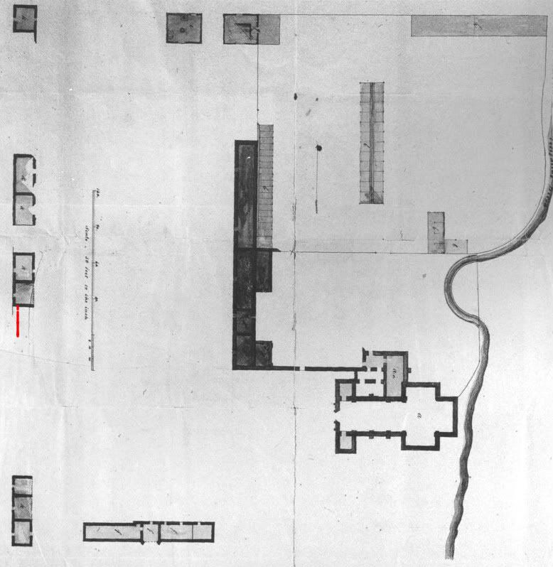  Sorry my arrows aren't showing up on the maps for some reason. I'm referring to the two buildings directly across from the long barracks. Cheers, Mike |
|
|
|
Post by Mike Harris on Jun 3, 2011 22:39:16 GMT -5
Anyone??  |
|
|
|
Post by Rich Curilla on Jun 15, 2011 23:33:50 GMT -5
Well, I feel your pain, Mike.  Unfortunately, I have had the same problem with my model and finally just went with Mark's comments in his book. I think you have already nailed down more possibilities. Mark used the 1.7 foot jog at the Trevino house. Bottom line is that I think it's still up for grabs. |
|
|
|
Post by Rich Curilla on May 3, 2014 2:02:30 GMT -5
Those of you who attended the Alamo Society Symposium in March have already heard Rick Range's presentation on the new conclusions (by Rick, Mike Harris and Craig Covner) regarding the architecture of the Alamo's west wall in 1836. Here are a few of my own model illustrations to help everyone visualize what has been presented. First, here is a my depiction of the west wall as we have envisioned it as the result of mission inventories and the archeological dig in the 1970's. It was believed to be composed of (in 1836) the remains of five 3-house structures with connecting walls between them, the whole combination stretching from the S.W. corner of the compound to the N.W. corner, a distance of 529 feet, according to Mr. Range. Some, but not all, of these five buildings had arcade porches of perhaps four arches on the eastern side facing the plaza. Some were built completely of stone; others of adobe. In 1836, the 18-pounder was emplaced on the ruins of the southern-most building (lower-left in illustration), and the N.W. cannon emplacement was on the ruins of the northern-most building. There was practically nothing left of the second building going south to north, the third became the Trevino House and Headquarters of the Alamo (depicted with gabled and shingled roof), the fourth housed Juana and Gertrudis Navarro during the siege and was owned by Francisco Castaneda, commander of the Compania Volante previously stationed in the Alamo, as was the northern-most building. The stone walls between the buildings were believed to be 8 feet high and probably loopholed for riflemen during the siege. According to later deed records, the building walls themselves (and their remnants forming part of the west wall of the compound) were 12.5 feet high.  The revamp has come about after Rick's careful new translation of the mission inventories and the discovery of details in archival deed records regarding heights of walls. The mission inventory revelation was that it seems the 15 Indian houses reported were not configured in five separate buildings of three houses each (as shown in 1836 ruined form in the above picture) but rather as one long structure of fifteen connected houses (as with other missions of the period) and originally had a porch or arcade fronting the whole row. This row stretched from the south end of the later Trevino House unbroken all the way to the N.W. corner of the compound. (My picture is actually a work-in-progress shot of my model with all the arches still intact before I deconstructed them but the houses already in their 1836 ruined condition. I used this so it would be clear that the arcade ran all the way along the front, a distance of 323 feet).  The third picture is depicting the probable condition of these buildings at the time of the Alamo siege. We do not know how much of the arcade remained, but at least three arches are still evident in the November 22, 1848, drawing by Seth Eastman. The individual remains of the Trevino, Southern Castaneda and Northern Castaneda houses are still configured as we previously believed, but the connecting walls between them were not just 8-foot high add-ons for defense against Indians but the actual 12.5 foot west sides of additional houses by then in total ruin. Interestingly, this results in exactly four windows in the west wall between the two northern houses, which matches General Cos' four cannon ports reported to Sam Houston by Green B. Jameson. By the time of the Alamo siege however, Jameson apparently relocated three of the guns, only leaving one aimed through the window probably just north of the southern Castaneda house.  |
|
|
|
Post by Rich Curilla on May 3, 2014 2:59:52 GMT -5
Our previous conception of the southern 207 feet of the west wall was that it consisted of the remains of two 3-house buildings with 12.5 foot high west walls connected by 8-foot high blank stone walls (as shown in the first picture above and this one), both buildings being of adobe brick, as determined from the archaeological dig which unearthed the footers of the southern-most structures. The famous 12-pound gunade was believed to have fired through one of the windows in the remaining west wall of the second building.  A newly discovered deed record however revealed that the Trevino House (Travis' H.Q.) connected to a 7-foot high stone wall that ran all the way to the S.W. corner and most likely around to the low barrack. This was just a wall with no buildings and no windows. The Pedro Charli carpenter shop was built of jacal construction in the S.W. corner and a partly adobe-partly jacal building was built against the west wall about 20 feet north of this. This became the "Artillery Command Post" of 1836 siege renowned. Neither of these building were constructed from pre-existing Indian houses, thus no part of the 7-foot high wall was 12.5 feet high as were all the Indian houses along the north half of the west wall. The gunade may have had to fire from ground level through an embrasure created in the wall near the Trevino house.  What's really scary is that this reduces the S.W. corner from 12.5 feet high to a mere 7 feet -- and thus the 18-pounder platform only needed to be 4.25 feet above the ground reducing the length of the ramp to 25.5 feet rather than 58 to 60 feet. All this being determined, the S.W. corner of the Alamo was a very vulnerable position. It also could explain why Col. Morales' column carried only two scaling ladders rather than 8 or 10 as did the other three attack columns. Soldados could very easily boost one another over a wall that was about the height of the door to my apartment.  Folks contributing to these fine efforts of Messrs. Range, Harris, and Covner include Brad Ponder, Jake Ivey and others. In addition, Mike Harris' incredibly detailed scale model of the Alamo is incorporating all of these new conclusions. |
|
|
|
Post by Mike Harris on May 5, 2014 8:42:44 GMT -5
Folks contributing to these fine efforts of Messrs. Range, Harris, and Covner include Brad Ponder, Jake Ivey and others. In addition, Mike Harris' incredibly detailed scale model of the Alamo is incorporating all of these new conclusions. [/quote]
Thanks, Rich, but you forgot to mention your HUGE contributions. Besides his incredible knowledge of the Alamo in general, the work Rich has done with his Sketchup model has been an enormous help to me in terms of how to portray the buildings in my model. When I'm struggling with how to create the look of a certain building within the compound, Rich can take my idea, create it in Sketchup and plug it into the compound (allowing a view from every angle!) so I can see how it looks or if I was totally off base. He'll also create the building how he sees it. This gives me options, but more importantly keeps me from having to create a building just to see if it looks right. Other than the church, I have constructed every building in my model at least twice and in some cases, four times! With a 1/72 scale model, that takes a while. I really can't thank him enough for his help and ideas on the west wall and the SW corner in particular. Your work has become an invaluable resource, pal. Amazing work! You da man, Rich!
Mike
|
|
|
|
Post by Rich Curilla on May 5, 2014 9:46:42 GMT -5
Thank mucho, Mike.  Frankly, if I had the space, I'd be building a real model myself. But I do have trouble facing redo's. When I find that I have to redo something, I tend to throw things. Today, the Alamo. Tomorrow, San Antonio de Bexar!!!! Excelsior!!!  |
|
|
|
Post by Jake on May 16, 2014 12:26:44 GMT -5
Wait, back up a bit. Although I gave Rick, Mike, and Craig information about the excavations and about some deeds, my position was, "The conclusions you reach from this are yours, and you can interpret the evidence in the way you see fit."
Myself, I think the five three-room buildings are the correct interpretation of the evidence, and in no way do I accept or agree with the continuous building and continuous arcade interpretation.
Oh, and that deed mentioning the 7-foot-high wall along most of the south half of the west wall? That was in 1827, well before any fortification took place.
And wow, Rich, that view of San Antonio from the east is terrific.
|
|
|
|
Post by Rich Curilla on May 17, 2014 1:05:03 GMT -5
And wow, Rich, that view of San Antonio from the east is terrific. Thanks, Jake. This virtual model has taken me by storm. It certainly is a viable medium for keeping up on and exploring the research -- and presenting the various conclusions. |
|
|
|
Post by Rich Curilla on May 17, 2014 1:35:16 GMT -5
|
|


 Unfortunately, I have had the same problem with my model and finally just went with Mark's comments in his book. I think you have already nailed down more possibilities. Mark used the 1.7 foot jog at the Trevino house. Bottom line is that I think it's still up for grabs.


 Frankly, if I had the space, I'd be building a real model myself. But I do have trouble facing redo's. When I find that I have to redo something, I tend to throw things. Today, the Alamo. Tomorrow, San Antonio de Bexar!!!! Excelsior!!!


