|
|
Post by TRK on Nov 28, 2007 12:47:11 GMT -5
When Col. Juan Almonte wrote in his journal on March 3, 1836, that "A
battery was erected on the north of the Alamo within musket
shot," was he referring to "musket shot" in the Napoleonic-era naval sense of about two hundred yards?
|
|
|
|
Post by stuart on Nov 28, 2007 13:37:36 GMT -5
In 1746, General Hawley (who was nobody's fool) referred to a "large musket shot" being 60 yards - 50 metres
|
|
|
|
Post by TRK on Nov 28, 2007 14:23:43 GMT -5
That's interesting, Stuart. If Hawley's "large musket shot" was, in effect, what Almonte was referring to, that would place the site of the northern battery toward the end of the siege about where the north side of the Post Office building comes--possibly even within the building. To verify this, just go to Google Earth, type in "The Alamo," zoom in, and use the ruler function to get the distance. (Make sure to turn off the "terrain" function on the toolbar; it makes for more accurate calibration.)
We know the Mexicans kept moving the "northern battery" closer to the Alamo during the siege, but by way of contrast, the Labastida map shows a battery at 250 varas (close to 250 yards) from the northeast corner of the Long Barracks extension.
|
|
|
|
Post by elcolorado on Nov 28, 2007 16:08:01 GMT -5
In 1746, General Hawley (who was nobody's fool) referred to a "large musket shot" being 60 yards - 50 metres I'm not sure, but I think we're talking about two different interpretations. Almonte may have been describing the distance a musket ball could travel when fired from the shoulder before it plowed into the ground. Gen Hawley may have meant the effective "killing range" of a smooth-bore musket. After 50 yds, the accuracy of a Brown Bess is greatly reduced. Moving a battery to within 60 yds of the Alamo's walls sounds like suicide to me. I believe the Alamo's defender's, with their long guns and cannon, would have had a "turkey shoot" at the Mexicans expense. Sanchez-Navarro's map also shows a battery at about the same range as Labastida. Navarro goes on to say: "Battery, under construction of the night of March 4 and finished on the 5th. At this site the reserve column made up of the battalion of Zapadores and the Grenade Company of the other battalions at the orders of Gen Santa Anna." I think it unlikely that Santa Anna's Reserves would have been positioned so close to the Alamo if the "musket range" in question was 60 yds. So I believe Col Almonte was most likely saying that the battery was no closer to the North Wall then 200 yds. Even that range seems too close for comfort. Glenn |
|
|
|
Post by stuart on Nov 28, 2007 16:15:06 GMT -5
I know it sounds close but the usage of the time was to refer to the effective range of muskets and pistols. Remember than sappers were so called because they "sapped" out to the position they were establishing, ie burrowed out, (and usually in the dark too) rather than digging in the open in daylight. Such close range was necessary to breach walls.
So far as the tactical reserve goes this would also figure, as it is also the distance a column could be expected to cover in the time it took to reload a musket, ie; they wouldn't take more than one volley on the way in.
|
|
|
|
Post by bmoses on Nov 28, 2007 20:34:33 GMT -5
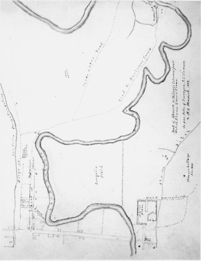
Dr. Morgan W. Merrick's 1853 sketch records the position of a Mexican battery along the Alamo Acequia just north and northeast of the compound. The map, drawn mainly to show events during the Battle of Bexar in 1835, also indicates some of the Mexican artillery positions in 1836. Notice that the sketch also shows the Molino Blanco near the upper edge of the map. Travis, in his letter of March 3, 1836, noted that there was an "entrenched encampment . . . at the old mill, eight hundred yards north." I had assumed that this was the Molino Blanco where Austin made his headquarters in November 1835 (also known as the Zambrano Mill, owned by Juan Manuel Zambrano). However, TRK plotted the distance and found that eight hundred yards (0.45 miles) is in fact the distance from the Alamo church to the west side of the river at 4th Street: i.e., the site of La Garza Mill (aka. the sugar mill, owned by José Antonio de la Garza). From the Alamo to the site of Molino Blanco is about .66 miles, or 1,160 yards. Conspicuously absent from the Merrick map is de la Garza’s Mill which should be located on the west bank of the river in the area where the “road to Burleson’s Camp” draws close to the river and angles toward the north. Samuel Maverick recorded activities that took place around Garza’s Mill during the December 1835 siege: [NOV.] 19TH, (1835) The Americans said to be erecting a battery one half [mile] this side of the mill, a little above La Garza's sugar mill. One lone gun fired (cannon); fired at the American camp at 11 or 12 o'clock at night. Nothing. No firing all day.
[NOV.] 21ST This a very cold, bleak, rainy day. The Americans are raising a battery or something not far from La Garza's sugar mill, one half mile this side of the Molina where Austin is.
NOV. 23RD Five cannon fired this morning from the battery of the Americans at or near the sugar mill of La Garza. During the 1836 siege of the Alamo, a vague reference is made regarding fortifications north of the Alamo by Francisco Becerra (interviewed in 1875). He stated that "a small work was commenced above the Alamo." Of course, it is not specified whether he was referring to an artillery position, but this entrenchment must have been begun around the 24th. Becerra later mentioned that the position north of the compound didn’t suit Santa Anna, so he ordered another made closer to the Alamo under the supervision of General Amado. The working party took advantage of the night to commence. The Texians discovered them, and kept up a heavy fire on them all night. They completed the little fort in due time. Fire was opened from it upon the Alamo. The battery northeast of the Alamo (the second mentioned by Sanchez Navarro in his journal) at a range of 150 toes or 822 feet (274 yards) is shown on his map at "R" where he notes it was directed by Pedro de Ampudia on the night of the 4th and dawn of the 5th (actually the 6th?). In the text, Sanchez Navarro says it has four pieces although his map implies four field pieces and two howitzers. This well documented battery also appears on La Bastida's map at a distance of 671.9 feet (224 yards) or 121.5 toesas. |
|
|
|
Post by bmoses on Nov 28, 2007 22:49:44 GMT -5
Its clear that the Merrick map above has errors (i.e., the S. A. River bends due west near the Molino Blanco). However, it is interesting to look at the ratio between some of features shown on the map. In ArcMap, I checked a distance from the Alamo's north wall (using the boundary marked on the sidewalk on Alamo Street at the Post Office) to the approximate location at the Molino Blanco (now the site of Providence High School). This distance measured 1,050 yards or 0.60 miles.
This distance was then used to establish a general scale for the Merrick map. Based on this overall distance, the measurement to the artillery position shown near the Alamo Acequia (immediately north northeast of the Alamo) is approximately 232 yards, or 0.13 miles. This location would place the battery near North Alamo Street a little north of midway between Third and Fourth Street. According to Google Earth, there is a parking lot in that area today.
|
|
|
|
Post by TRK on Nov 29, 2007 8:42:46 GMT -5
The thing that strikes me about a Mexican battery positioned to the northeast of the northeastern corner of the Alamo compound is that it would not have been the best location for reducing exterior walls. Whether firing at the north wall or the east walls (corrals, barracks, and long barracks), there would have been a +- 45-degree deflection. When solid shot is fired at masonry or any other hard object at that angle, the thickness and resistance of the object is effectively increased.
Apparently, a primary reason the successive "northern" batteries (i.e., those we know from the Labastida and Sanchez Navarro maps) were to the northeast of the Alamo is that the Mexicans were using the Alamo acequia as a means of covering their movements as they erected these siege works. It's possible that these batteries were adequately placed for a general bombardment of the fort and for suppressing the Texan batteries in the northeast of the fort. However, it seems that a location to the northeast of the fort was much less than optimal for creating breaches in the walls.
|
|
|
|
Post by Allen Wiener on Nov 29, 2007 9:15:36 GMT -5
Which, again, raises the question of how effective the bombardment was. Did the Mexican batteries do any real damage to the fort? The long-fabled breach in the north wall never happened. We also had a discussion elsewhere on how much shot was actually fired up to the final days of the siege, and it did not appear to be much (based on Mexican records of ammunition used). I don't recall how much bombardment took place at night, which is alleged to have kept the Texians awake, especially in the final few days. But, other than possibly keeping them awake, how much good did the Mexican batteries actually do the besiegers? Would the assault on March 6 have been much different without the bombardment?
AW
AW
|
|
|
|
Post by stuart on Nov 29, 2007 10:33:48 GMT -5
The thing that strikes me about a Mexican battery positioned to the northeast of the northeastern corner of the Alamo compound is that it would not have been the best location for reducing exterior walls. Whether firing at the north wall or the east walls (corrals, barracks, and long barracks), there would have been a +- 45-degree deflection. When solid shot is fired at masonry or any other hard object at that angle, the thickness and resistance of the object is effectively increased. It is in fact the other way round. When solid shot hit a wall at 90 degrees it literally meets it head on. However glancing blows from an angle will steadily spaul (or peel) bits off. |
|
|
|
Post by TRK on Nov 29, 2007 10:41:56 GMT -5
Ah...my mistake. I was (mis)applying what I know of sloping armor in tank warfare.
|
|
|
|
Post by stuart on Nov 29, 2007 11:15:58 GMT -5
Easy assumption to make, but stone and abobe reacts rather differently to steel!
|
|
|
|
Post by Herb on Nov 29, 2007 12:06:06 GMT -5
Which, again, raises the question of how effective the bombardment was. Did the Mexican batteries do any real damage to the fort? The long-fabled breach in the north wall never happened. We also had a discussion elsewhere on how much shot was actually fired up to the final days of the siege, and it did not appear to be much (based on Mexican records of ammunition used). I don't recall how much bombardment took place at night, which is alleged to have kept the Texians awake, especially in the final few days. But, other than possibly keeping them awake, how much good did the Mexican batteries actually do the besiegers? Would the assault on March 6 have been much different without the bombardment? AW AW The bombardment really needs to be broken down in to two phases. Phase 1 was February 23 until General Ampudia arrived and took over direct supervision of the artillery and repositioned the North Battery on 4 March. During this Phase, the artillery other than supporting the Mexican probing attacks, was primarily used to harass the defenders, based on Travis' letter of March 3rd, the average was only a couple of rounds total per hour. Travis also noted that the walls were generally proof against the artillery. Phase 2 lasted from March 4th to Sunset on March 5th. From Goliad we have a couple of accounts (probably brought by Allen) of the last days. According to these accounts cannon shot was going through the walls toward the end. According to the Expended Munitions report of General Ampudia (Hansen, 377), if you accept Travis's 200 rounds fried through March 3, then 300 -400 rounds were fired the final 18 hours vs 200 the first 11 days. While there are no documented reports of the Phase 2 bombardment dismounting any cannon or opening a breech it did create enough damage that the garrison was up past midnight making repairs on March 5th. Given the intensity of the Phase 2 bombardment, it is doubtful that anybody got any real sleep on March 4th, then staying up most of the night on March 5th - led to the sleeping garrison on March 6th. While 48 hours without sleep doesn't sound like much compared to the romance of 13 days, the effect on already tired men was overwhelming. |
|
|
|
Post by tmdreb on Nov 29, 2007 21:51:02 GMT -5
Morgan Wolfe Merrick and ArcMap? Wow, two things I thought I was alone in familiarity with here.
As far as the bombardment goes, the purpose may have been more along the lines of lobbing explosive shells inside the walls rather than knocking them down.
|
|
|
|
Post by TRK on Nov 30, 2007 10:37:54 GMT -5
I wonder if, when Merrick made that map in 1853 (at the age of fourteen), vestiges of the "northern battery" and associated entrenchments were still somewhat visible, or if locals simply pointed out the location to him? According to contemporary maps, the area hadn't been developed by the mid-1840s, but streets had been laid out there by the time of the Civil War.
|
|